<<
5-Waters-Volume-4-Stormwater
19 Tai Tapu Stormwater Scheme
19.1 Scheme Summary
Scheme Area
| 34.01 ha |
| Scheme Coverage (as at 1 Jan 2021) | Rating numbers | 204
|
System components
| Piped (m) | 5,950
|
| Swales (m) | 5,094
|
| Drains (m) | 1,637
|
| Manholes/Inspection Chambers (No.) | 50
|
| Treatment | 5 Attenuation basins
|
| Other | Pump chamber
3 soakholes
|
Value ($)
| Replacement Cost | $2,459,581
|
| Depreciated Replacement Cost | $2,139,824
|
| Financial | Operator cost (scheduled and reactive maintenance) per connection
| $63.91/connection
|
Planning
| Stormwater Management Plan | 1
|
| No. SDC stormwater consents | 2
|
Demand
| Mean Annual Rainfall (mm) | 608 |
| 10% AEP (10 year) 1hr rainfall depth (mm) | 18.6 |
| Sustainability | Sustainable drain management practices | Adopted and Encouraged |
19.2 Key Issues
The following key issues are associated with the Tai Tapu Stormwater Scheme. A list of district wide issues are located in 5Waters Activity Management Plan: Volume 1.
Table 19‑1 Tai Tapu Scheme Issues
| Flooding of the Tai Tapu township including property flooding during moderate rainfall events when the Halswell River level prevents gravity discharge. | New flood pump helps minimise flooding. Continue to investigate alternative pumping options and discuss with the community. |
19.3 Overview & History
The stormwater network is a predominantly piped system discharging to the Halswell River (managed by Environment Canterbury) which runs along the townships northern boundary. Some piping is located in State Highway 75 (SH75) and therefore maintained by the New Zealand Transport Agency (NZTA).
A large stormwater basin, located on the eastern side of SH75 (School Road) was constructed in 2002. This serves as a temporary retention area during large events, taking upper catchment (Otahuna) stormwater and protecting Tai Tapu urban property. Regular general maintenance is undertaken on this basin.
When the level of the Halswell River cover the stormwater outlet at the Soliders Memorial, temporary overpumping is required during rainfall events.
A level transducer in the School Road basin is alarmed for activation of pumping. A tractor powered pump stored at the Environment Canterbury depot in Tai Tapu is part owned by the Council for use in this location. In 2015 Council purchased a new civil defence pump that has priority use for stormwater pumping in Tai Tapu. This pump has a capacity of approximately 190 CIS at 10m head. OPUS calculated maximum inflow to the Soliders memorial manhole at 400 l/s. Additional pumps are required to supplement this pump in a large event. Operations and maintenance manuals, a standard operating procedure and memorandum of understanding have been created for the use of the civil defence pump and associated notification procedures.
Flooding occurred in June 2013. Additional pumps were hired to supplement the tractor powered pump.
New flood pump is now available for use on this scheme.
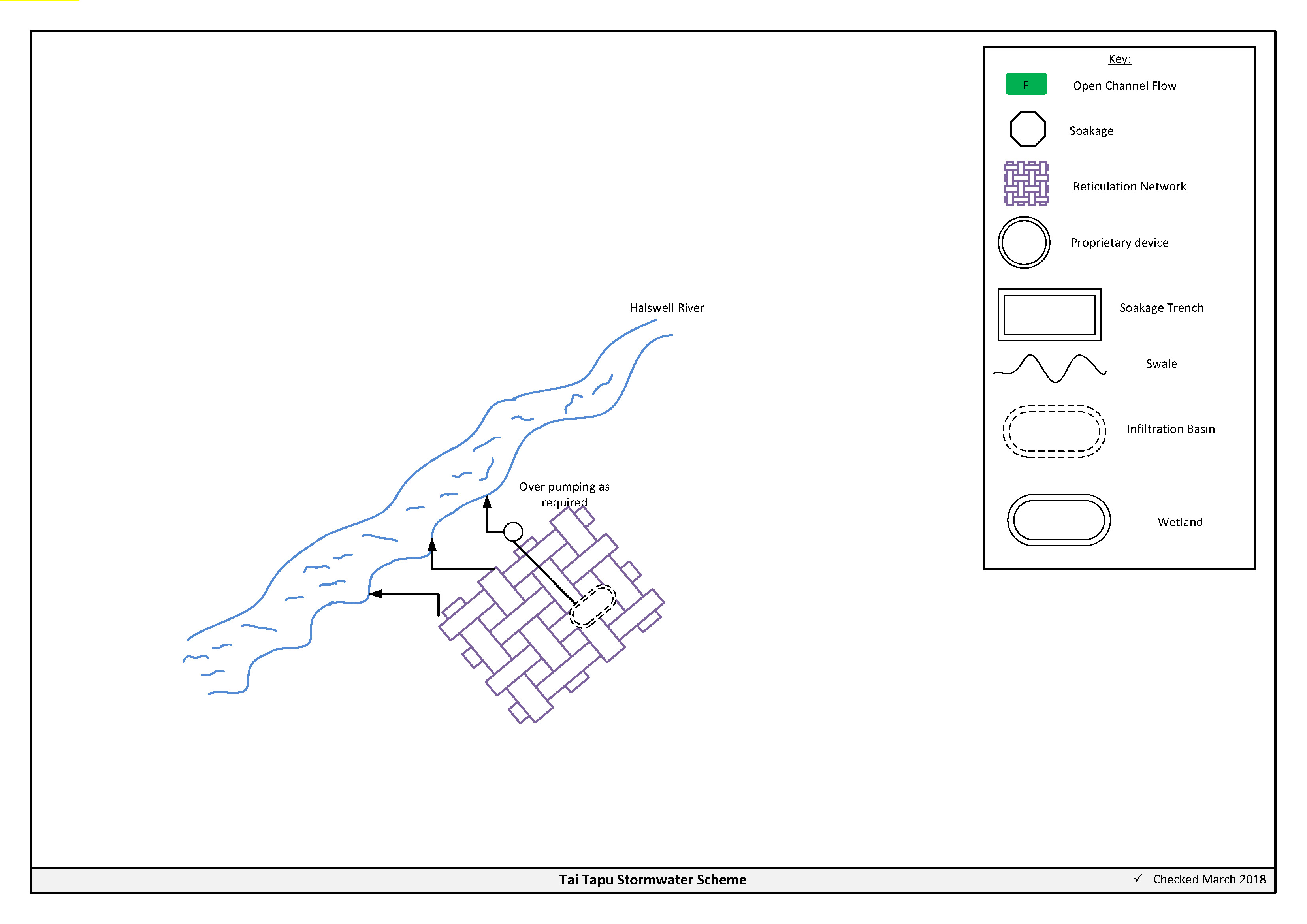
Figure 19‑2 Scheme Schematic
19.4 Resource Consents
The Tai Tapu stormwater scheme has a number of resource consents. Table 19-2 shows the stormwater discharges permitted by the resource consents for this scheme.
Table 19‑2 Resource Consents
CRC020099
Issued - Active | Certificate of Compliance
To pump floodwater from Tai tapu township to the Halswell River when gravity drainage is cut off by high river levels and flooding of roads and property is occurring. | Halswell River, INTERSECTN TAITAPU ROAD & SH75 | 14/12/2001 | N/A
|
CRC167468
Application in Process | To discharge stormwater to land and to surface water from the existing stormwater network of Tai Tapu.
| Tai Tapu, Selwyn | TBC
| TBC
|
CRC020099 is a certificate of compliance, therefore has no expiry date.
There are two consents held by developers for this area.
19.5 Integrated Stormwater Management Plan
An ISMP has been lodged for Tai Tapu (in March 2016) as part of the application for CRC167468.
19.6 Scheme Assets
Council has a wide variety of stormwater assets within the district. A brief description of the assets within this scheme is provided below:
a. Reticulated network – Includes pipes, manholes, sumps. The primary purpose of the reticulated network is to collect and convey stormwater. Historically these systems were designed for the 2 year storm event. Today's engineering standards require the piped network to be designed for a 10 year event with overland flow provision for up to the 50 year event.
b. Infiltration basin – is a stormwater management device which is used to store, treat and dispose of stormwater to the ground via soakage.
c. Open drains – are channels used to convey stormwater. They are cost effective means to convey large volumes of water.
A summary of material and diameter for channels and pipes, where known, is shown below in Figure 19‑3 and Figure 19‑4.
Figure 19‑3 Pipe Material – Tai Tapu
Figure 19‑4 Pipe Diameter – Tai Tapu
19.7 Operational Management
The stormwater network is operated and maintained under two maintenance contracts as follows:
- Contract 1241: Water Services Contract. Contract is with SICON who undertakes investigations, conditions inspections, proactive and reactive maintenance and minor asset renewals.
- Contract 1202: Parks and Reserves Contract. Contract is with SICON who undertakes the maintenance of land scape features related to water services e.g. mowing, gardens etc.
Water quality sampling is completed under an agreement with Food and Health Ltd as required.
19.8 Photos of Main Assets
The photos below provide a summary of the types of assets found within this stormwater management area.
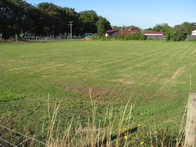
Photo 1 – School Road Basin
|
19.9 Rapid Flood Modelling
The Council has undertaken 'Rapid Flood Hazard Assessment' modelling for its main townships. The modelling uses DHI MIKE 21 to simulate rainfall on grid with the outputs processed through ArcGIS producing maps illustrating a range of flood deeps during different rainfall intensities and durations.
The rapid flood assessment has been generated to provide a high level summary of potential flood and ponding areas across the district during extreme rainfall events. The results from this study are not to be used to set floor levels. The results have not been ground tested and therefore are indicative only.
For a 50 year event, Figure 19‑5 shows the predicted flooding for Tai Tapu.

Figure 19‑5 Rapid Flood Modelling, Tai Tapu
19.10 Risk Assessment
A risk assessment has been undertaken for the Tai Tapu scheme. The key output from the risk assessment is the identification of any extreme and high risks which need to be mitigated. In order to mitigate these risks they have been included and budgeted for in the projects within this LTP. Table 19‑3 details the risk priority rating and Table 19‑4 outlines the risks for this scheme.
Table 19‑3 Risk Priority Rating
| > 50 | Extreme | Awareness of the event to be reported to Council. Urgent action to eliminate / mitigate / manage the risk. Document risk and action in the AMP. |
| 35-50 | Very High | Risk to be eliminated / mitigated / managed through normal business planning processes with responsibility assigned. |
| 14-35 | High | Manage risk using routine procedures. |
| 3.5-14 | Moderate | Monitor the risk. |
< 3.5
| Low | Awareness of the event to be reported to Council. Immediate action required to eliminate / mitigate / manage the risk. Document risk and action in the AMP. |
Table 19‑4 Risks – Tai Tapu
| Otahuna - formalising overland flow paths (neighbourly disputes) | Otahuna - review and confirm overland flow paths | 2014 | 12 | 12 | 6 |
| Pump doesn't have enough capacity | New portable pump | 2014 | 20 | 10 | 10 |
The list of district wide risks can be found in 5Waters Activity Management Plan: Volume 1.
19.11 Asset Valuation Details
The total replacement value of assets within the Tai Tapu Scheme is $2,459,581 as detailed in Table 19‑5 below.
Table 19‑5 Replacement Value, Tai Tapu
Stormwater Reticulation
| Channel | $239,362
|
| Inlet-Outlet-Point | $84,574
|
| Lateral | $105,763
|
| Management Device | $218,771
|
| Manhole | $313,356
|
| Pipe | $1,470,540
|
Valve
| $27,215
|
19.12 Renewals
The renewal profile has been taken from the 2019 5 Waters Valuation. A graph showing the renewals for this scheme are shown by Figure 19‑6 below. The majority of assets requiring renewal are culverts/pipes which occur in the period 2043 to 2047.
Figure 19‑6 Tai Tapu Stormwater Renewal Profile
19.13 Critical Assets
The criticality model for Tai Tapu has been updated for the 2021 AcMP. The methodology of the criticality model can be found in 5Waters Activity Management Plan: Volume 1 and it provides details of how the criticality has been calculated for the reticulation assets. Table 19‑6 and Figure 19‑7 below show the calculated criticality for all of the assets within this scheme that have a recorded known length.
Table 19‑6 Length of Assets per Criticality Level
5
| Low | 9,209
|
4
| Medium-Low | 540
|
3
| Medium | 609
|
2
| Medium-High | 312
|
1
| High | 0
|
19.14 Asset Condition
The asset condition model was run for Tai Tapu in 2021. The methodology of the model can be found in 5Waters Activity Management Plan: Volume 1 and it provides details of how the model has been calculated for the reticulation assets (particularly pipes). Figure 19‑8 below shows the level of asset condition for all of the assets within this scheme that have a recorded known condition.
Table 19‑7 provides a description of the condition rating used within the condition model.
Table 19‑7 Asset Condition Grading
| 1.0 | Excellent |
| 2.0 | Good |
| 3.0 | Moderate |
| 4.0 | Poor |
| 5.0+ | Fail |
19.15 Funding Program
The 10 year budgets are shown by Table 19‑8. Budgets are split into expenditure, renewals, projects and capital projects. Expenditure and renewals have been reported on a district-wide basis in Volume 1.
All figures are ($) not adjusted for CPI “inflation". They are calculated on historical data, and population growth where relevant.
Table 19‑8 Budget Summary
| 2021/2022 | -
| $20,000
|
2022/2023
| -
| $20,000
|
| 2023/2024 | -
| $170,000
|
| 2024/2025 | -
| -
|
| 2025/2026 | -
| -
|
| 2026/2027 | -
| -
|
| 2027/2028 | -
| - |
2028/2029
| -
| -
|
2029/2030
| -
| -
|
2031/2032
| -
| -
|
| Total | -
| $210,000
|
An explanation of the categories within the budgets are as follows below:
-
Expenditure consists of operation and maintenance costs;
-
Renewals are replacement of assets which are nearing or exceeded their useful life;
-
Projects are investigations, decisions and planning activities which exclude capital works; and
-
Capital projects are activities involving physical works.
Table 19‑9 Key Projects
Capital Projects
| -
| Private drain running from farm through to town basin: upgrade
| -
| $20,000
| $170,000
| -
| 100% LoS
|
Capital Projects
| -
| SCADA site at bridge
| $20,000
| -
| -
| -
| 100% LoS
|
* Where LoS refers to Level of Service and G refers to Growth
The list of district wide projects can be found in 5Waters Activity Management Plan: Volume 1.
Discussion on Projects
Projects have been determined based on their:
- Relevance to the scheme
- Requirement to be completed under legislation
- Ability to bring the scheme up to or maintain the Level of Service required under council's Asset Management Policy.
Many projects are jointly funded by more than one scheme and activity. Each scheme pays a pro-rata share only, equivalent to the number of connections.
Discussion on Capital and Projects
Where relevant, Capital (Levels of Service) and Capital (Growth) projects have been included in the scheme financial details.
Levels of Service Projects and growth splits have been provided to ensure the costs of population driven works are clear.
<<
5-Waters-Volume-4-Stormwater