<<
5-Waters-Volume-5-Land-Drainage
7 Osbornes (No. 4) Drainage District
7.1 Scheme Summary
Scheme Area
| 1,791.77 ha |
Scheme Coverage in Ha.
(as at 1 July 2020)
| Class A
| 1,232
|
Class B
| 276 |
Class C
| 332 |
Systems components
| Drain Length (m) | 10,252 |
| Pump stations (No.) | 1 |
| Other assets | Rock sediment and aeration bunds; weirs
|
| History | Installation Date | Installed progressively from 1850's |
Value ($)
| Replacement Cost | $2,537,453
|
| Depreciated Replacement Cost | $2,433,201
|
Financial
| Annual maintenance cost % of total Land Drainage maintenance
| $5,000/year on average
3% of total Land Drainage maintenance spend
|
| Drainage Outlet | Ultimate discharge point | Te Waihora (Lake Ellesmere)
|
| Sustainability | Sustainable drain management practices | Adopted and Encouraged |
7.2 Key Issues
The following key issues are associated with the Osbornes Drainage District. A list of district wide issues are located in 5Waters Activity Management Plan: Volume 1.
Table 7‑1 Osbornes Drainage District Key Issues
| Council's reliance on volunteers (Committee Members) to operate Council Assets and ensuring their health and safety. | Continued communication with Committee members regarding any issues or concerns. |
| Changing expectations of stakeholders regarding water quality discharge. | Council to continue to monitor water quality and impact of physical works undertaken as part of the Osbornes Working Party |
| Aging infrastructure and potential costs associated with pump upgrades and renewals. | Budget for future upgrade works. Continue to strive to manage operational costs. |
7.3 Overview & History
The Osbornes scheme has a rating area of 1790ha, servicing a total area of 1620ha between Halswell Cannel and Hudson Roads with the main drainage outlets for this scheme via the Osbornes Pump Station. The ultimate receiving environment for this area is Te Waihora (Lake Ellesmere).
Total length of classified drains is 9km.
Below is a summary of the drainage scheme history taken from the publication 'Osbornes Drain and Pumping Scheme – An Evaluation' July 1989
1868
| Regular lake openings began
|
1889
| Halswell Canal constructed
|
****
| Drain re-routed through stone-faced bank direct to the lake
|
1955
| Double, manually operated flood gate installed within stop bank
|
1962/63
| Osbornes Pump Scheme initiated by North Canterbury Catchment Board
|
1967/68
| Scheme constructed under supervision of the Ellesmere County Council
|
1968
| First pump reading was taken late May 1968
|
Prior to European settlement most of the area was a shallow bay covered by the high levels of Te Waihora (Lake Ellesmere). The land drain running through the catchment (Osbornes drain) originally flowed into the Halswell Canal via a wooden floodgate in the stone face bank. Improvements in the Halswell drainage system keep the canal levels high so the drain was rerouted through the stone face bank directly to the Lake. In 1955 a double, manually operated, floodgate was installed.
The upgrade of this land drainage scheme was initiated by the then North Canterbury Catchment Board in 1962/63 and was constructed under the supervision of the then Ellesmere County Council. The scheme provided for two pumps with a combined capacity of approximately 1.7 cumecs designed to cope with all floodwaters, except under extreme rainfall. The main canal is designed to act as a ponding area. From an economic return perspective the capital works had a return on investment of 3 years. However this did not consider the impact of drainage water on lake health and cultural impact.
On 24 Feburary 2017 a discharge consent for Osbornes Drain was granted. This is the outcome of collaborative working party.
In 2011, a variation to the Te Waihora Water Conservation Order was made, bringing a strong cultural focus into place. The Selwyn - Waihora Zone Committee (established under the Canterbury Water Management Strategy) also released its Zone Implementation Plan (ZIP) and ZIP addendum.
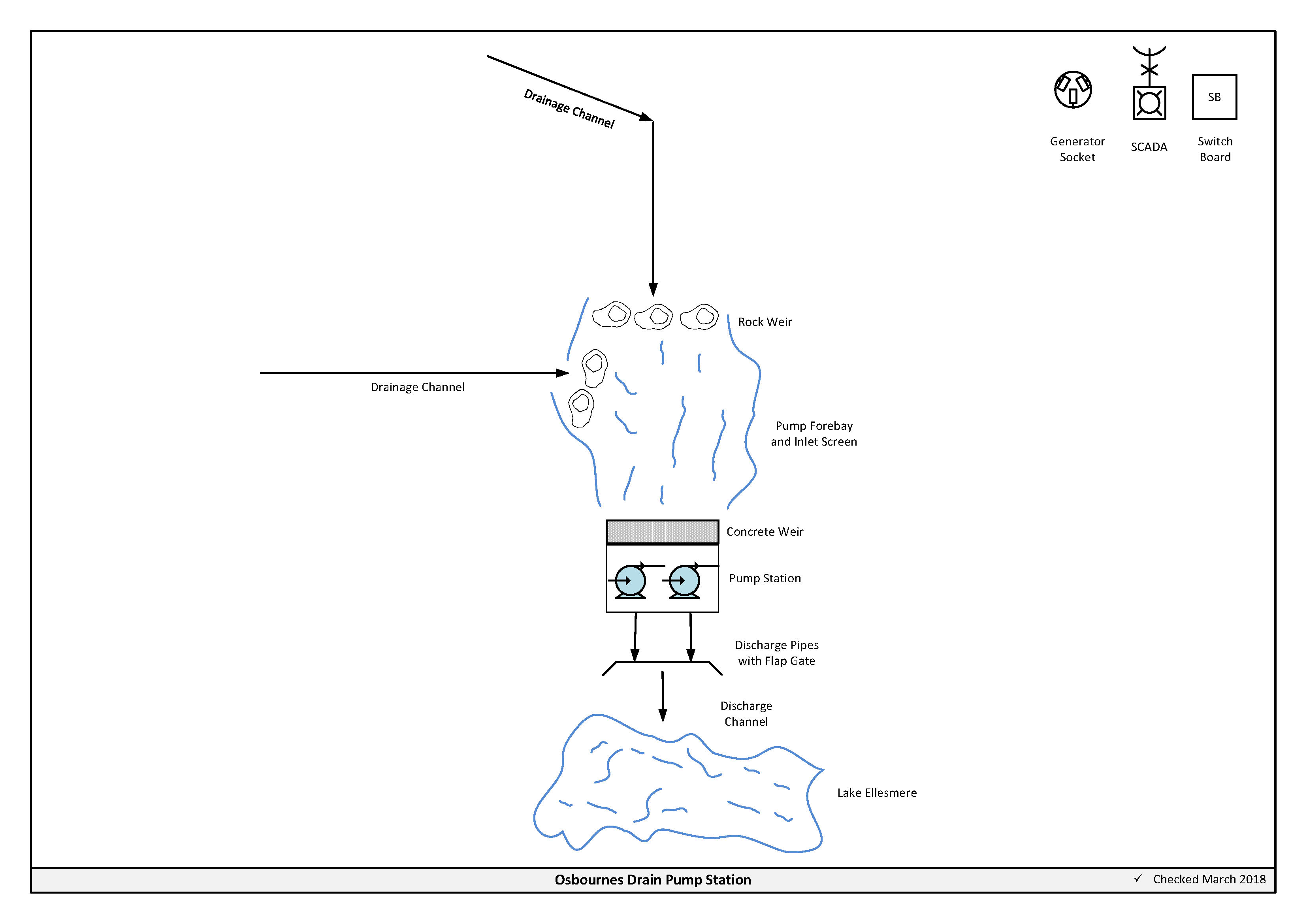
Figure 7‑2 Scheme Schematic
7.4 Resource Consents
Table 7‑2 outlines the resource consents for this scheme.
Table 7‑2 Resource Consents
| CRC172230 | To excavate material and distrurb the bed and banks of a surface water body. | Osbornes Drain, Motukarara | 24/02/2017 | 24/02/2027 | Issued - Active |
| CRC172231 | To discharge water that may contain contaminants into Osbornes Drain | Osbornes Drain, Motukarara | 24/02/2017 | 24/02/2027 | Issued - Active |
7.5 Scheme Assets
This scheme is predominately Land drainage channels which are excavated open channels that intercept, convey and discharge groundwater to allow productive use of land.
No summary of material and diameter of these channels is available for this scheme.
7.5.1 Pump Station
The pumping hours change substantially over the year. Figure 7‑3 shows the amount of pumping hours required in 2014.
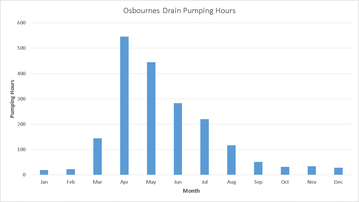
Figure 7‑3 Pumping Hours
A new switchboard was installed in 2013 enabling the pumpstation to be connected to SCADA. Text alerts are received by the drainage committee. The Drainage committee is comprised of landowners in the area. Several monitor any increase in drain water levels that would indicate pump failure/power outages etc.
7.6 Operational Management
Council delegates some aspects of management of the Land Drainage network to 9 Land Drainage Committee's comprising of local residents with an interest in the Land Drainage network. Council Service Delivery Staff work alongside the Committee's to prioritise and facilitate maintenance activities which are undertaken by a number of local contractors. The Osbornes Drain Pumpstation is managed by the Osbornes Land Drainage Committee supported by specialist contractors as required.
7.7 Photos of Main Assets
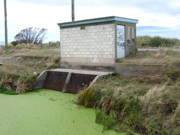
Photo 1: Osbornes Pump Shed – Intake
| 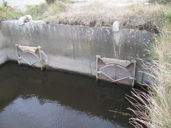
Photo 2: Osbornes Pumpshed - Outlet
|
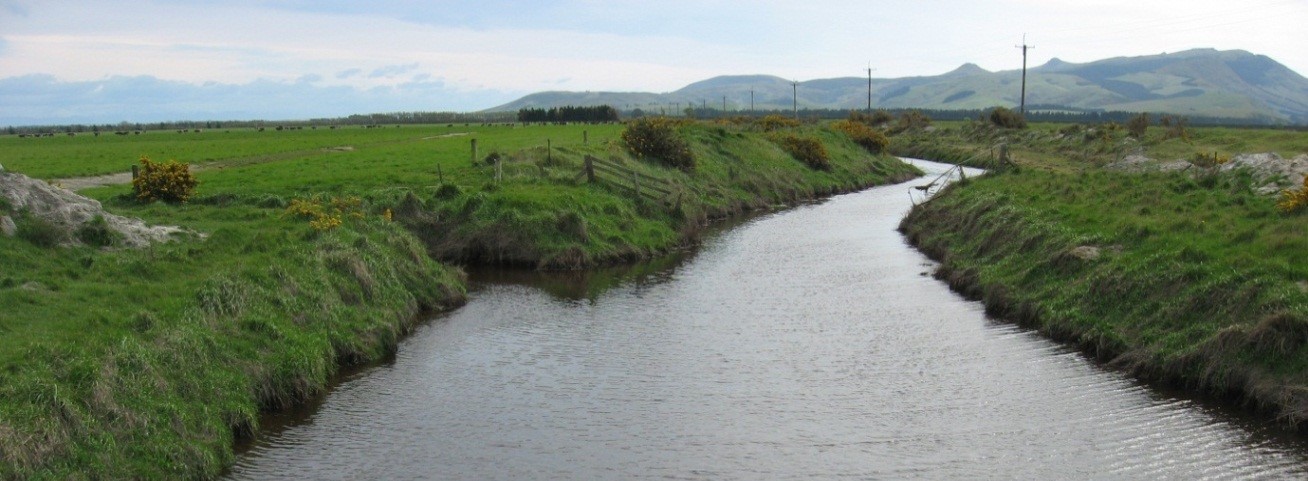
Photo 3: Main Channel
|
7.8 Risk Assessment
A risk assessment has been undertaken for the Osbornes Drain scheme. The key output from the risk assessment is the identification of any extreme and high risks which need to be mitigated. In order to mitigate these risks they have been included and budgeted for in the projects w7ithin this LTP. Table 7‑3 details the risk priority rating, Table 7‑4 outlines the risks for this scheme and Table 7‑8 details the key projects.
Table 7‑3 Risk Priority Rating
| > 50 | Extreme | Awareness of the event to be reported to Council. Urgent action to eliminate / mitigate / manage the risk. Document risk and action in the AMP. |
| 35-50 | Very High | Risk to be eliminated / mitigated / managed through normal business planning processes with responsibility assigned. |
| 14-35 | High | Manage risk using routine procedures. |
| 3.5-14 | Moderate | Monitor the risk. |
| < 3.5 | Low | Awareness of the event to be reported to Council. Immediate action required to eliminate / mitigate / manage the risk. Document risk and action in the AMP. |
Table 7‑4 Risks – Osbornes Drain
| Pump failure due to age | Pump renewal | 2017 | | 4 | 0.7 |
| Pump failure due to age | Pump renewal design | 2017 | | 4 | 0.7 |
| Water quality does not meet aspirations of key stakeholders | Water quality improvements | 2014 | 27 | 27 | 27 |
The list of district wide risks can be found in 5Waters Activity Management Plan: Volume 1.
7.9 Asset Valuation Details
The total replacement value of assets within the Osbornes Drainage Scheme is $2,537,453 with further details in Table 7‑5 below.
Table 7‑5 Replacement Value, Osbornes Drainage District
Plant and Equipment
| $217,152
|
Land Drainage
| Channel | $2,296,976
|
| Feature | $23,326
|
Channels are broken down into drains, pipes and stock banks. The Osbornes Drain Land drainage district is made up of classified drains.
7.10 Renewals
The renewal profile has been taken from the 2019 5 Waters Valuation. A graph showing the renewals for this scheme is shown by Figure 7‑4 below.
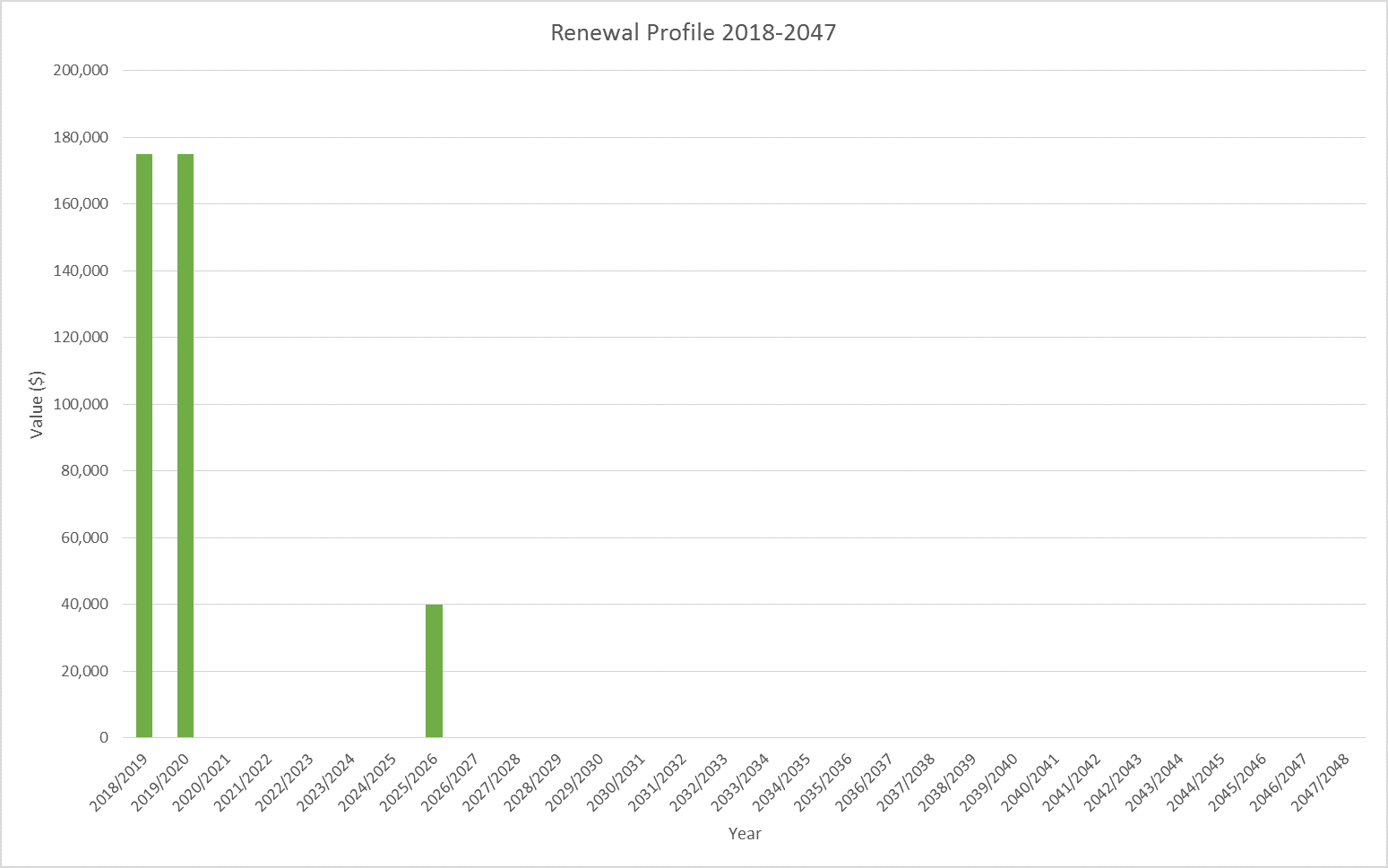
Figure 7‑4 Osbornes Drain Renewal Profile
7.11 Critical Assets
The criticality model for Osbornes Drain has been updated for the 2021 AcMP. The methodology of the criticality model can be found in 5Waters Activity Management Plan: Volume 1 and it provides details of how the criticality has been calculated for the reticulation assets. Table 7‑6 and Figure 7‑5 below show the calculated criticality for all of the assets within this scheme that have a recorded known length.
Table 7‑6 Length of Assets per Criticality Level
5
| Low | 6,549
|
4
| Medium-Low | 0 |
3
| Medium | 1,327 |
2
| Medium-High | 2,490 |
1
| High | 0
|
7.12 Asset Condition
The asset condition model was run for Osbornes Drain in 2021. The methodology of the model can be found in 5Waters Activity Management Plan: Volume 1 and it provides details of how the model has been calculated for the reticulation assets (particularly pipes). There is no known recorded condition for assets within this scheme.
7.13 Funding Program
The 10 year budgets for Osbornes Drain are shown by Table 7‑7. Budgets are split into expenditure, renewals, projects and capital projects. Expenditure and renewals have been reported on a district-wide basis in Volume 1.
All figures are ($) not adjusted for CPI “inflation". They are calculated on historical data, and population growth where relevant.
Table 7‑7 Osbornes Drain Budget Summary
| 2021/22 | $100,000
| -
|
| 2022/2023 | -
| -
|
| 2023/2024 | $100,000
| -
|
| 2024/2025 | -
| -
|
| 2025/2026 | -
| -
|
| 2026/2027 | -
| -
|
2027/2028
| -
| -
|
2028/2029
| - | -
|
2029/2030
| -
| -
|
2030/2031
| -
| -
|
|
Total | $200,000
| -
|
An explanation of the categories within the budgets are as follows below:
- Expenditure consists of operation and maintenance costs;
- Renewals are replacement of assets which are nearing or exceeded their useful life;
- Projects are investigations, decisions and planning activities which exclude capital works; and
- Capital projects are activities involving physical works.
There is one project for the Osbornes drainage district in the LTP budget.
Table 7‑8 Key Projects
| Capital Projects | 455390006 | WQ Improvements | $100,000
| - | $100,000
| -
| 100% LoS |
* LoS refers to Level of Service
The list of district wide projects can be found in 5Waters Activity Management Plan: Volume 1.
Discussion on Projects
Projects have been determined based on their:
- Relevance to the scheme
- Requirement to be completed under legislation
- Ability to bring the scheme up to or maintain the Level of Service required under council's Asset Management Policy.
Many projects are
jointly funded by more than one scheme and activity. Each scheme pays a pro-rata share only, equivalent to the number of connections.
Discussion on Capital and Projects
Where relevant, Capital (Levels of Service) and Capital (Growth) projects have been included in the scheme financial details.
Levels of Service Projects and growth splits have been provided to ensure the costs of population driven works are clear.
<<
5-Waters-Volume-5-Land-Drainage