<<
5-Waters-Volume-5-Land-Drainage
8 Taumutu Drainage District
8.1 Scheme Summary
Scheme Area
| 653.60 ha |
Scheme Coverage in Ha
(as at 1 July 2020)
| Class A | 157
|
Class B
| 185
|
Systems components
| Drain Length (m) | 10,437
|
| Pump stations (No.) | None
|
| Other assets | Pipes, Headwalls |
| History | Installation Date | Installed progressively from 1850's |
Value ($)
| Replacement Cost | $2,076,480
|
| Depreciated Replacement Cost | $1,766,022
|
| Financial | Annual maintenance cost % of total Land Drainage maintenance
| $12,070/year on average
7% of total Land Drainage maintenance spend
|
Drainage Outlet
| Ultimate discharge point | Te Waihora (Lake Ellesmere) |
| Sustainability | Sustainable drain management practices | Adopted and Encouraged |
8.2 Key Issues
The following key issues are associated with the Taumutu Drainage District. A list of district wide issues are located in 5Waters Activity Management Plan: Volume 1.
Table 8‑1 Taumutu Drainage District Key Issues
| Continued erosion of redundant SDC outfall structure at the Salmon Farm. | Continue to inspect annually (SDC staff) and undertake any physical works to make structure safe. Isolate location minimises risk to the public. |
| Coastal migration inland and continued erosion of outfall structures. | Annual inspections by SDC staff to continue. |
8.3 Overview & History
The Taumutu scheme has a rating area of 655ha, servicing a total area of 8,780ha between Leeston Taumutu and Smiths Roads. The ultimate receiving environment for this area is the Pacific Ocean.
The Taumutu Drainage District is divided into two distinct parts - Taumutu Drains and Taumutu Culverts. Information about Taumutu Culverts can be found in 9.0 Taumutu Culverts.
In 2011, a variation to the Te Waihora Water Conservation Order was made, bringing a strong cultural focus into place. The Selwyn - Waihora Zone Committee (established under the Canterbury Water Management Strategy) also released its Zone Implementation Plan (ZIP) and ZIP addendum.
8.4 Resource Consents
A resource consent is held to divert water from Coopers drain.
Table 8‑2 Resource Consents
| CRC916349 | To divert water from Coopers Lagoon, at or about map reference M37:556-043, via an open channel to a channel leading to the No 4 outfall to maintain the static level of Coopers Lagoon. | Coopers Lagoon, SEDGEMERE | 6-May-93 | 30-Apr-28 | Issued - Active |
The occupation of the culverts in coastal marine area is a permitted activity as per Environment Canterbury letter dated 10th November 2010.
In addition, the follow agreement applies (Table 8-3).
Table 8‑3 Resource Consent Agreement
| Drainage Easement Agreement, Muriwai (Coopers Lagoon) | The easement makes provision for the maintenance of McEvedy's Culvert, including extension or relocation from time to time | Jul-01 |
Land drainage activities are controlled through Rules 5.57 and 5.58 under the Land and Water Plan. An application was lodged in November 2011, with a request that it be put on hold pending discussion with stakeholders.
8.5 Scheme Assets
This scheme is predominately Land drainage channels which are excavated open channels that intercept, convey and discharge groundwater to allow productive use of land.
No summary of material and diameter of these channels is available for this scheme.
8.6 Operational Management
Council delegates some aspects of management of the Land Drainage network to 9 Land Drainage Committee's comprising of local residents with an interest in the Land Drainage network. Council Service Delivery Staff work alongside the Committee's to prioritise and facilitate maintenance activities which are undertaken by a number of local contractors.
8.7 Photos of Main Assets
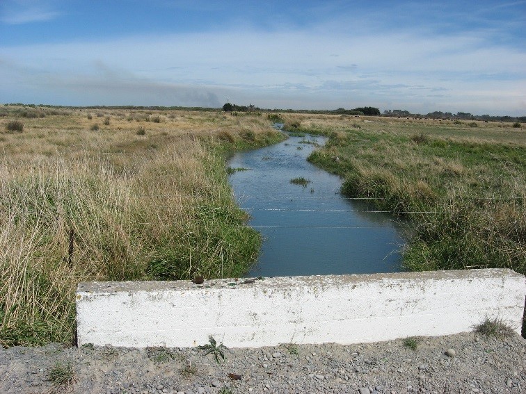
Photo 1: Land Drainage channel looking towards the lake
|
8.8 Risk Assessment
A risk assessment has been undertaken for the Taumutu scheme. The key output from the risk assessment is the identification of any extreme and high risks which need to be mitigated. In order to mitigate these risks they have been included and budgeted for in the projects within this LTP. No high risks have been identified for this scheme.
8.9 Asset Valuation Details
The total replacement value of assets within the Taumutu Land Drainage Scheme is $2,076,480 with further details in Table 8‑4 below.
Table 8‑4 Replacement Value, Taumutu
Land Drainage
| Channel
| $2,026,511
|
| Feature | $49,969
|
Channels are broken down into drains, pipes and stock banks. The Taumutu Land drainage district is made up of classified drains.
8.10 Renewals
The renewal profile has been taken from the 2019 5 Waters Valuation. There are some renewals in 2026/27.
Figure 8‑2 Taumutu Renewal Profile
8.11 Critical Assets
The criticality model for Taumutu Drainage District has been updated for the 2021 AcMP. The methodology of the criticality model can be found in 5Waters Activity Management Plan: Volume 1 and it provides details of how the criticality has been calculated for the reticulation assets. Table 8‑5 and Figure 8‑3 below show the calculated criticality for all of the assets within this scheme that have a recorded known length.
Table 8‑5 Length of Assets per Criticality Level
5
| Low | 3,080
|
4
| Medium-Low | 1,848
|
3
| Medium | 2,778 |
2
| Medium-High | 2,647 |
1
| High | 0
|
8.12 Asset Condition
The asset condition model was run for the Taumutu drainage district in 2021. The methodology of the model can be found in 5Waters Activity Management Plan: Volume 1 and it provides details of how the model has been calculated for the reticulation assets (particularly pipes). There is no known recorded condition for assets within this scheme.
8.13 Funding Program
There are no projects specific to the Taumutu scheme in the 10 year LTP budgets, however the scheme will benefit from a number of district-wide initiatives. The list of district wide projects can be found in 5Waters Activity Management Plan: Volume 1.
<<
5-Waters-Volume-5-Land-Drainage