<<
5-Waters-Volume-5-Land-Drainage
6 L2 Drainage District
6.1 Scheme Summary
Scheme Area
| 4,755.06 ha |
Scheme Coverage -Capital value (as at 1 July 2020)
| Class A | $154,365,245
|
| Class B | $169,200,295
|
Class C
| $449,967,170
|
Class D
| $25,031,830
|
Class D
| $24,675,840
|
Class F
| $647,994,230
|
Systems components
| Drain Length (m) | 77,250
|
| Pump stations (No.) | None |
| Other assets | Pipes, Headwalls |
| History | Installation Date | Installed progressively from 1850's |
Value ($)
| Replacement Cost | $8,204,995
|
| Depreciated Replacement Cost | $8,180,463
|
Financial
| Annual maintenance cost % of total Land Drainage maintenance
| $52,000/year on average
29% of total Land Drainage maintenance spend
|
| Drainage Outlet | Ultimate discharge point | Te Waihora (Lake Ellesmere) |
| Sustainability | Sustainable drain management practices | Adopted and Encouraged |
6.2 Key Issues
The following key issues are associated with the L2 Drainage District. A list of district wide issues are located in 5Waters Activity Management Plan: Volume 1.
Table 6‑1 L2 Drainage District Key Issues
| Flooding in lower catchment | Continue to monitor. Investigate increased frequency of weed cutting and regular dredging for potential 10 year program. |
| Increased sediment loading to the catchment from new subdivisions. | Continue to monitor water quality as per stormwater consent conditions and investigate any non-compliances. |
| Classified drains in urban areas and changing community expectations regarding level of maintenance undertaken. | Council to consider how these drains are managed in the future. |
6.3 Overview & History
The L2 drainage scheme has a rating area of 4,755ha, servicing a total area of 6,690ha roughly between Hudson and Powells Roads with drainage outlets for this scheme via the L2 river (enhanced for drainage purposes). The ultimate receiving environment for this area is Te Waihora (Lake Ellesmere).
L1 River
The L1 River becomes a classified drain in the Lincoln township south of South Belt (see maps). The L2 Committee is responsible for maintenance of all classified drains in the scheme. The L1 within the Ryelands reserve has traditionally been hard cleaned by ECan clearing gangs and prison gangs, funded by Council budgets. Areas of the L1 not classified are private land owner responsibility.
L2 River
The L2 starts at the edge of Lincoln township, with spring and water race fed base flows. It also takes stormwater flows from Lincoln and Springston.
Council is creating a number of esplanade strips along the L2 south of Southfield drive. Council are responsible for maintaining vegetation in these esplanade strips.
The L2 relies on a clear river to convey groundwater, spring flows and stormwater away from Lincoln township and arable land along the way via Yarrs Lagoon to Te Waihora / Lake Ellesmere.
In addition to roadside excavator cleaning, the L2 drainage scheme also has a weed cleaning consent. Weed is cut in-river, and trapped in downstream booms installed near the lower end of Wolfes Road. The weed is then removed from the river and stockpiled to dry, being left to compost.
Yarrs Lagoon
Yarrs Lagoon area comprises of an area of approximately 76.9 hectares described as Reserve 3706. Its boundaries were defined by the then Springs County Council Reclamation and Empowering Act of 1915. This Act was promulgated by the former Springs County in 1915 following public pressure from the local community for it take some action to alleviate the flooding of adjacent farmland by the L2 river caused by the nature of the lagoon and the stream at that time. The adjoining Yarrs property was underwater for long periods making it uneconomic and unfarmable while various areas of Yarrs Road were frequently flooded. The purpose of the Act was to “improve the flow of the L2 River through Yarrs lagoon and the drainage of adjoining lands". Essentially this allows council to manage the lagoon in the way of reclamation, drainage, willow removal etc. Spraying of willows on the drain edge was undertaken in 2012/2013.
Paparua Water Race
Flow from the Paparua water race scheme (from Waimakariri River) flows into the top sections predominantly through soakhole systems to mitigate the potential for didymo (if present) to enter the system of the L2 drainage scheme. This occurs predominantly during the winter period and significantly reduces during the peak summer periods.
In 2011, a variation to the Te Waihora Water Conservation Order was made, bringing a strong cultural focus into place. The Selwyn - Waihora Zone Committee (established under the Canterbury Water Management Strategy) also released its Zone Implementation Plan (ZIP) and ZIP addendum.
6.4 Resource Consents
Resource consents are held for weed cutting.
Table 6‑2 Resource Consents
| CRC000818.1 | To erect, reconstruct and use a structure across the LII River, at or about map reference NZMS 260 M36:6565-2180, for the purpose of capturing cut weed. | Lii River, LAKE ELLESMERE | 19-Jan-12 | 19-Nov-34 | Issued – Active |
CRC000819
| To discharge cut weed into Lake Ellesmere/Te Waihora at or about map reference NZMS 260 M36:6624-2001. | Lii River, LAKE ELLESMERE | 22-Nov-99 | 19-Nov-34 | Issued - Active |
Land drainage activities are controlled through Rules 5.57 and 5.58 under the Land and Water Plan. An application was lodged in November 2011, with a request that it be put on hold pending discussion with stakeholders.
The Springs County Council Recalmation and Empowering Act, 1915 empowers the Springs County Council to reclaim parts of Yarr's Lagoon for the purpose of improving the flow of the L2 River through the lagoon.
6.5 Scheme Assets
The L2 river is a largely human modified system. This scheme is predominately Land drainage channels which are excavated open channels that intercept, convey and discharge groundwater to allow productive use of land.
This scheme also has a weed cutting boat which is a diesel powered paddle wheel boat with cutting blades at the front which extend into water in a 'U' shape.
A summary of material and diameter for pipes, where known, is shown below in Figure 6‑2 and Figure 6‑3.
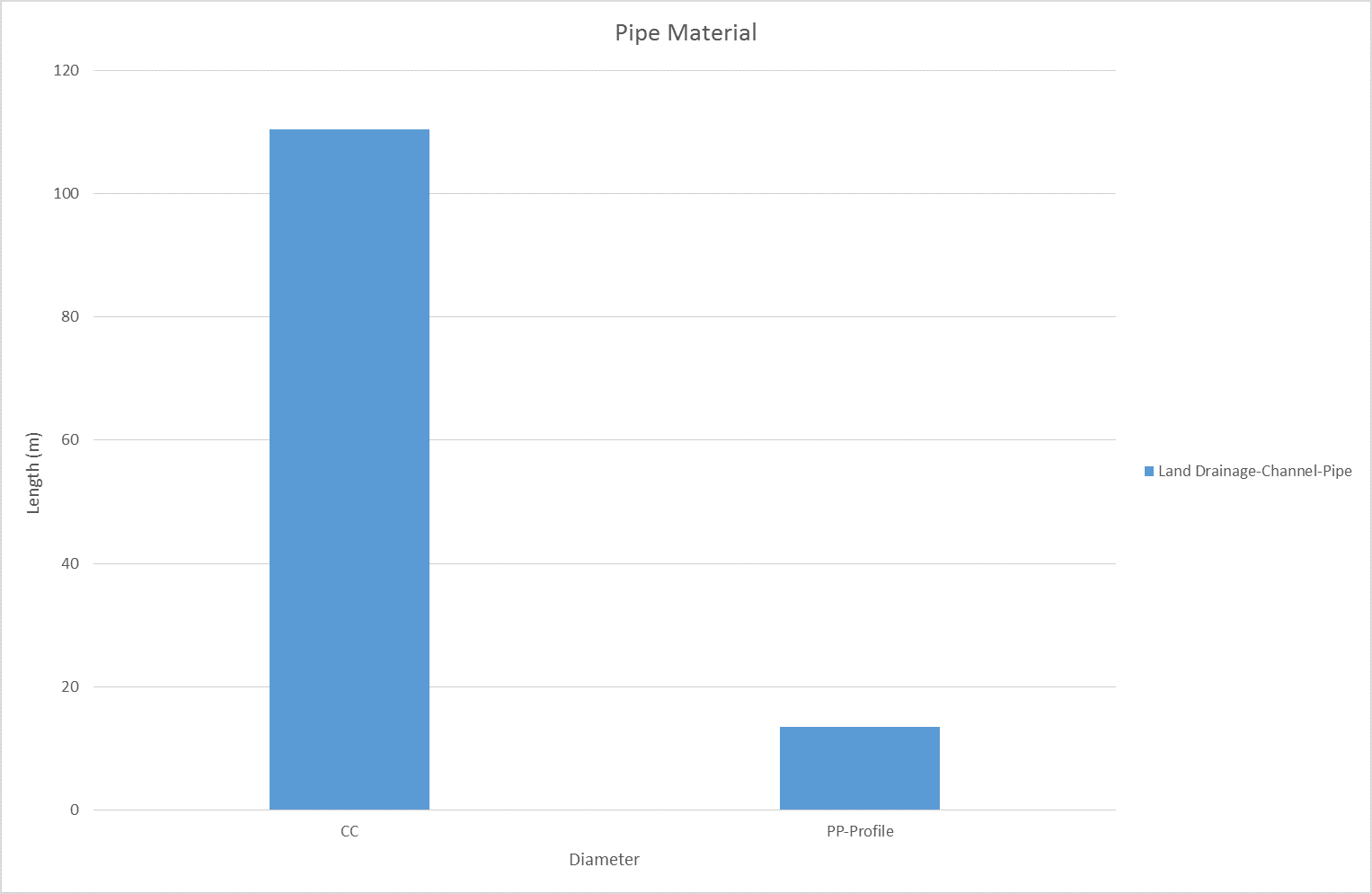
Figure 6‑2 Pipe Material – L2
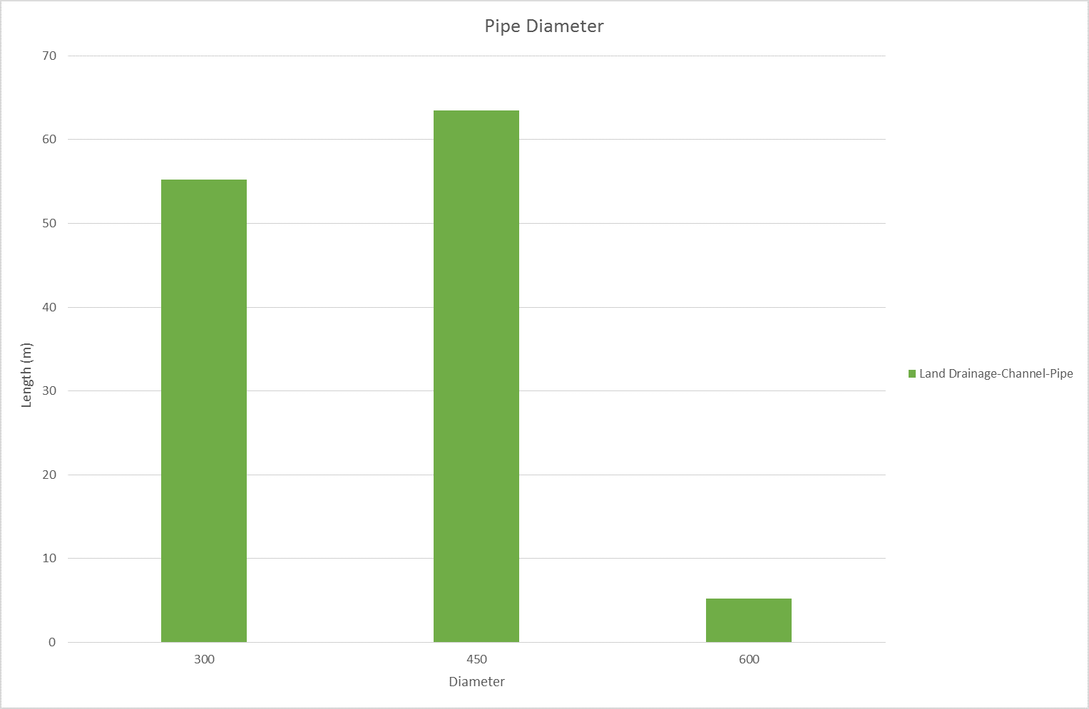
Figure 6‑3 Pipe Diameter – L2
6.6 Operational Management
Council delegates some aspects of management of the Land Drainage network to 9 Land Drainage Committee's comprising of local residents with an interest in the Land Drainage network. Council Service Delivery Staff work alongside the Committee's to prioritise and facilitate maintenance activities which are undertaken by a number of local contractors.
6.7 Photos of Main Assets
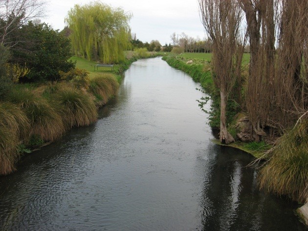
Photo 1: L2 looking downstream from Collins Rd
| 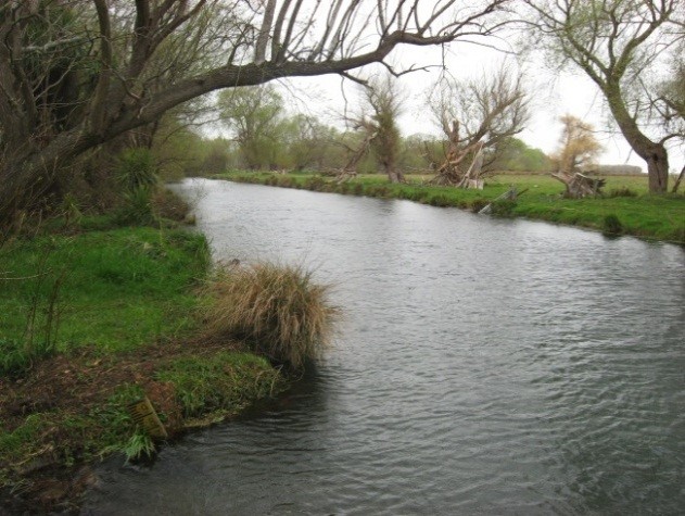
Photo 2: L2 looking downstream from Wolfes Rd
|
6.8 Risk Assessment
A risk assessment has been undertaken for L2 scheme. The key output from the risk assessment is the identification of any extreme and high risks which need to be mitigated. In order to mitigate these risks they have been included and budgeted for in the projects within this LTP. No high risks have been identified for this scheme.
6.9 Asset Valuation Details
The total replacement value of assets within the L2 Drainage Scheme is $8,204,995 with further details in Table 6‑3 below.
Table 6‑3 Replacement Value, L2
Land Drainage
| Channel | $8,199,369
|
| Feature | $5,626
|
Channels are broken down into drains, pipes and stock banks. The L2 Land drainage district is made up of classified drains, pipes and headwalls.
6.10 Renewals
The renewal profile has been taken from the 2019 5 Waters Valuation. A graph showing the renewals for this scheme are shown by Figure 6‑4 below. The assets requiring renewal are pipes and headwalls which occur in the year 2032/33.
Figure 6‑4 L2 River Renewal Profile
6.11 Critical Assets
The criticality model for the L2 has been updated for the 2021 AcMP. The methodology of the criticality model can be found in 5Waters Activity Management Plan: Volume 1 and it provides details of how the criticality has been calculated for the reticulation assets. Table 6‑4 and Figure 6‑5 below show the calculated criticality for all of the assets within this scheme that have a recorded known length.
Table 6‑4 Length of Assets per Criticality Level
5
| Low | 54,002
|
4
| Medium-Low | 4,806
|
3
| Medium | 15,122
|
2
| Medium-High | 2,845
|
1
| High | 0 |
6.12 Asset Condition
The asset condition model was run for the L2 drainage district in 2021. The methodology of the model can be found in 5Waters Activity Management Plan: Volume 1 and it provides details of how the model has been calculated for the reticulation assets (particularly pipes). There is no known recorded condition for assets within this scheme.
6.13 Funding Program
The 10 year budgets for L2 River District are shown by Table 6‑5. Budgets are split into expenditure, renewals, projects and capital projects.
All figures are ($) not adjusted for CPI “inflation". They are calculated on historical data, and population growth where relevant.
Table 6‑5 L2 River Budget Summary
| 2021/2022 | $20,000
| -
|
| 2022/2023 | $20,000
| -
|
| 2023/2024 | -
| -
|
| 2024/2025 | $20,000
| -
|
| 2025/2026 | $5,000
| -
|
| 2026/2027 | -
| -
|
| 2027/2028 | $20,000
| -
|
2028/2029
| $5,000
| -
|
2029/2030
| -
| -
|
2030/2031
| $20,000
| -
|
|
Total | $110,000
| -
|
An explanation of the categories within the budgets are as follows below:
- Expenditure consists of operation and maintenance costs;
- Renewals are replacement of assets which are nearing or exceeded their useful life;
- Projects are investigations, decisions and planning activities which exclude capital works; and
- Capital projects are activities involving physical works.
There are two projects for L2 drainage district in the LTP budget.
Table 6‑6 Key Projects
| Projects | 4549010 | Engineering inspection of Weed Boat
| -
| -
| -
| $10,000 | 100% LoS |
Projects
| 4549013
| L2 sediment survey
| $20,000
| $20,000
| -
| $60,000
| 100% LoS
|
* LoS refers to Level of Service; G refers to Growth
The list of district wide projects can be found in 5Waters Activity Management Plan: Volume 1.
Discussion on Projects
Projects have been determined based on their:
- Relevance to the scheme
- Requirement to be completed under legislation
- Ability to bring the scheme up to or maintain the Level of Service required under council's Asset Management Policy.
Many projects are
jointly funded by more than one scheme and activity. Each scheme pays a pro-rata share only, equivalent to the number of connections.
Discussion on Capital and Projects
Where relevant, Capital (Levels of Service) and Capital (Growth) projects have been included in the scheme financial details.
Levels of Service Projects and growth splits have been provided to ensure the costs of population driven works are clear.
<<
5-Waters-Volume-5-Land-Drainage