<<
5-Waters-Volume-5-Land-Drainage
5 Leeston Drainage District
5.1 Scheme Summary
Scheme Area
| 10,607.13 ha |
Scheme Coverage in Ha
(as at 1 July 2020)
| Class A
| 977
|
Class B
| 1,388
|
Class C
| 6,321
|
Class D
| 1,129
|
Min charge
| 286
|
Systems components
| Drain Length (m) | 212,880
|
| Pump stations (No.) | None
|
| Other assets | Pipes, Weirs, Headwalls
|
| History | Installation Date | Installed progressively from 1850's |
Value ($)
| Replacement Cost | $22,312,345
|
| Depreciated Replacement Cost | $22,027,109
|
Financial
| Annual maintenance cost % of total Land Drainage maintenance
| $83,619/year on average
46% of total Land Drainage maintenance spend
|
| Drainage Outlet | Ultimate discharge point | Te Waihora (Lake Ellesmere) |
| Sustainability | Sustainable drain management practices | Adopted and Encouraged |
5.2 Key Issues
The following key issues are associated with the Leeston Drainage District. A list of district wide issues are located in 5Waters Activity Management Plan: Volume 1.
Table 5‑1 Leeston Key Issues
| Proposed changes to drainage patterns around the Leeston township as part of the Leeston stormwater mitigation project. | Continue to consult with the community including those outside the township. |
| Sewer discharges from Ellesmere Treatment Plant to Volckman Road Drain at times of high groundwater and flows. Flooding in the township impacts volumes to the treatment plant. | Discharges undertaken in line with consent conditions. |
| Potential failure of Hamner Drop Structures | Regular Engineering Inspection, Weight restrictions, renewals |
| Flooding in the township from classified drains including Leeston Creek and the upper catchment. Leeston Creek and others undersized for both the flows from the township and upper catchment. | Completion of stormwater mitigation measures which went to public vote in May 2014. Continued monitoring and early warning of rising creek levels. |
| Access to clean Leeston Creek through the township. Not all parts of the Creek are accessible by machine and costs for hand cleaning are high. | Annual cleaning of Leeston Creek to be planned and budgeted for within stormwater budgets |
5.3 Overview & History
The Leeston drainage district is segregated into two management areas – 'Leeston Rural' and 'Leeston Township'. The 'Leeston Township' budget was amalgamated with the 'Leeston Stormwater' budget. The Leeston scheme has a rating area of 10,400ha, servicing a total area of 21,150ha between Brookside and Irwell Road and with drainage outlets for this scheme discharging to Te Waihora (Lake Ellesmere).
The Leeston Township management area sits within the greater Leeston Rural area and as the name suggests is limited to the bounds of the Leeston Township.
The leeston urban drainage district is managed by the leeston urban drainage committee. The boundary of the district includes leeston creek, pound road drain down to the diversion structure at the outlet of the show grounds culvert. Flooding occurred by leeston creek in June 2013 and a diversion is planned for the town which is discussed in the Leeston stormwater Activity Management Plan. Regular maintenance on the creek is required to cut back vegetation and remove obstructions from the bed. This was undertaken in December 2013 subsequent to the floods once water levels had dropped.
The Leeston Rural management area sits outside the Leeston township boundary.
In 2011, a variation to the Te Waihora Water Conservation Order was made, bringing a strong cultural focus into place. The Selwyn - Waihora Zone Committee (established under the Canterbury Water Management Strategy) also released its Zone Implementation Plan (ZIP) and ZIP addendum.
Hanmer's Drain
Hanmer's drain was deepened for flood relief measures in 1945 in conjunction with the general upgrading of drains within the Ellesmere area. The Hanmer's drain is different in that it was designed for both drainage and flood relief.
Reinforced concrete drop structures were installed at 14 locations to reduce flood flow velocities. On account of the shortage of steel, concrete access bridges were designed with mass concrete abutments and only the decks were reinforced. Some structures are beginning to experience spalling and concrete erosion.
Engineering inspections of the drop structures are undertaken periodically.
5.4 Resource Consents
There are existing resource consents for Leeston urban land drainage scheme. Historically flooding in the township has inundated low lying houses. Consent has been granted consent for a flood diversion which incorporates stormwater in a development area of Leeston North (Manse Road; CRC143914).
To also assist with flood mitigation a flood diversion structure (gate) was constructed at the downstream end of the Leeston township which when opened discharges stormwater down drain 58 which ultimately discharges to the Tramway reserve drain above Lochheads Road. The consent for this diversion is covered under CRC930163.
Table 5‑2 Resource Consents
| CRC930163 | To dam Leeston Creek by means of an existing concrete structure and to divert flow to Tramway Reserve Drain. | Leeston And Springston Roads, LEESTON
| 29-Aug-95 | 28-Jul-29 | Issued - Active |
CRC143914 (replaced CRC071838.2)
| To discharge contaminants into surface water
| Pound Road Leeston, Dunsandel Road & Manses Road, LEESTON
| 22-Jan-14
| 24-Aug-42
| Issued - Active
|
Land drainage activities are controlled through Rules 5.57 and 5.58 under the Land and Water Plan. An application was lodged in November 2011, with a request that it be put on hold pending discussion with stakeholders.
5.5 Scheme Assets
There are three main scheme assets within this scheme:
- Land drainage channels - excavated open channels that intercept, convey and discharge groundwater to allow productive use of land.
- Drop structures - engineered weirs will stilling basins designed to dissipate energy and minimise erosive velocities.
- Flood Level Gauge - Telemetry linked water level pressure transducer used to prelude alarms during rising flood levels.
A summary of material and diameter for pipes, where known, is shown below in Figure 5‑2 and Figure 5‑3.
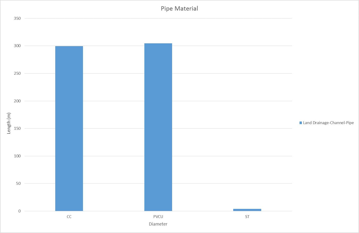
Figure 5‑2 Pipe Material - Leeston
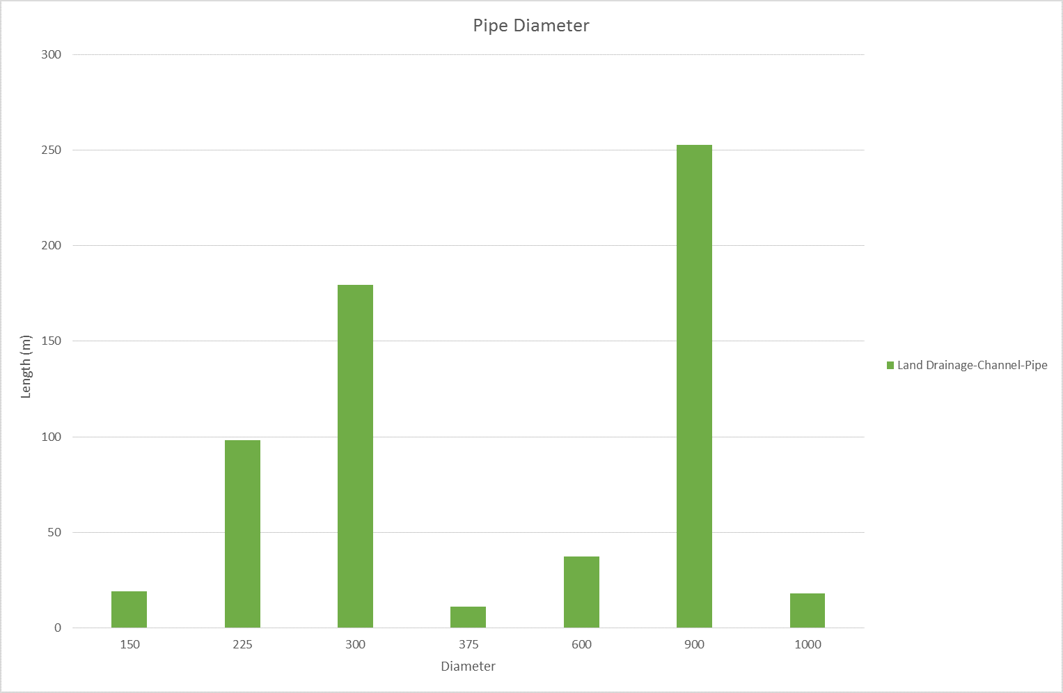
Figure 5‑3 Pipe Diameter – Leeston
5.6 Operational Management
Council delegates some aspects of management of the Land Drainage network to 9 Land Drainage Committee's comprising of local residents with an interest in the Land Drainage network. Council Service Delivery Staff work alongside the Committee's to prioritise and facilitate maintenance activities which are undertaken by a number of local contractors.
5.7 Photos of Main Assets
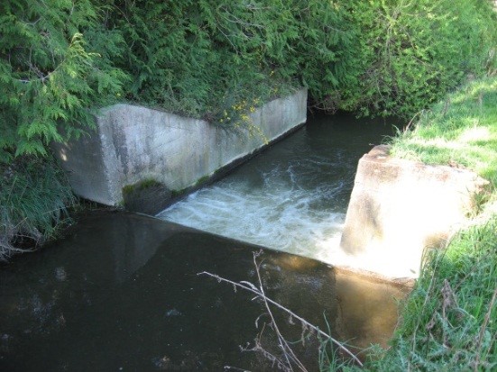
Photo 1: Hanmer Drop Structure
| 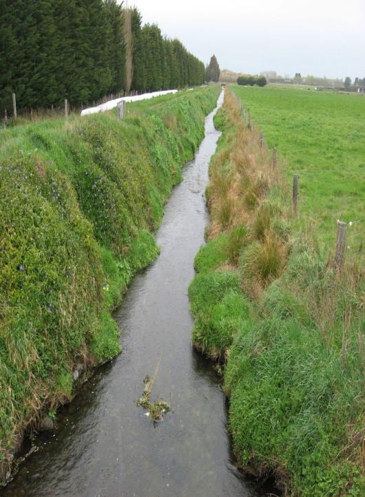
Photo 2: Tramway Reserve Drain
|
5.8 Risk Assessment
A risk assessment has been undertaken for the Leeston scheme. The key output from the risk assessment is the identification of any extreme and high risks which need to be mitigated. In order to mitigate these risks they have been included and budgeted for in the projects within this LTP. Table 5‑3 details the risk priority rating, Table 5‑4 outlines the risks and the list of key projects is found in Table 5‑8.
Table 5‑3 Risk Priority Rating
| > 50 | Extreme | Awareness of the event to be reported to Council. Urgent action to eliminate / mitigate / manage the risk. Document risk and action in the AMP. |
| 35-50 | Very High | Risk to be eliminated / mitigated / managed through normal business planning processes with responsibility assigned. |
| 14-35 | High | Manage risk using routine procedures. |
| 3.5-14 | Moderate | Monitor the risk. |
| < 3.5 | Low | Awareness of the event to be reported to Council. Immediate action required to eliminate / mitigate / manage the risk. Document risk and action in the AMP. |
Table 5‑4 Risks – Leeston
| Drain and culvert capacities within the township are largely unknown | Review drain capacities and report on upgrade strategy | 2014 | 6 | 6 | 6 |
The list of district wide risks can be found in 5Waters Activity Management Plan: Volume 1.
5.9 Asset Valuation Details
The total replacement value of assets within the Leeston Land Drainage District is $22,312,345 with further details in Table 5‑5 below. The majority of value is made up of channels.
Table 5‑5 Replacement Value, Leeston (Rural and Urban)
Land Drainage
| Channel | $22,018,758
|
| Feature | $293,587
|
Channels are broken down into drains, pipes and stock banks. The Leeston land drainage district is made up of drains and pipes.
5.10 Renewals
The renewal profile has been taken from the 2019 5 Waters Valuation. Renewals are scheduled for Leeston are shown in Figure 5‑4 below.
Figure 5‑4 Leeston Renewal Profile
5.11 Critical Assets
The criticality model for Leeston has been updated for the 2021 AcMP. The methodology of the criticality model can be found in 5Waters Activity Management Plan: Volume 1 and it provides details of how the criticality has been calculated for the reticulation assets. Table 5‑6 and Figure 5‑5 below show the calculated criticality for all of the assets within this scheme that have a recorded known length.
Table 5‑6 Length of Assets per Criticality Level
5
| Low
| 156,051
|
4
| Medium-Low | 23,755
|
3
| Medium | 19,637 |
2
| Medium-High | 8,501
|
1
| High | 0 |
5.12 Asset Condition
The asset condition model was run for Leeston in 2021. The methodology of the model can be found in 5Waters Activity Management Plan: Volume 1 and it provides details of how the model has been calculated for the reticulation assets (particularly pipes). There is no known recorded condition for assets within this scheme.
5.13 Funding Program
The 10 year budgets for Leeston are shown by Table 5‑7. Budgets are split into expenditure, renewals, projects and capital projects. Expenditure and renewals have been reported on a district-wide basis in Volume 1.
All figures are ($) not adjusted for CPI “inflation". They are calculated on historical data, and population growth where relevant.
Table 5‑7 Leeston Budget Summary
| 2021/2022 | -
| -
|
2022/2023
| -
| -
|
2023/2024
| -
| -
|
2024/2025
| -
| -
|
2025/2026
| $5,000
| -
|
2026/2027
| -
| -
|
2027/2028
| -
| -
|
2028/2029
| $5,000
| -
|
2029/2030
| -
| -
|
2030/2031
| -
| -
|
|
Total | $10,000
| -
|
An explanation of the categories within the budgets are as follows below:
- Expenditure consists of operation and maintenance costs;
- Renewals are replacement of assets which are nearing or exceeded their useful life;
- Projects are investigations, decisions and planning activities which exclude capital works; and
- Capital projects are activities involving physical works.
There is one project for this scheme.
Table 5‑8 Key Projects
| Projects | 4545011 | Drop Structures - Hanmer Road - engineering inspection
| -
| -
| -
| $10,000 | 100% LoS |
* LoS refers to Level of Service
The list of district wide projects can be found in 5Waters Activity Management Plan: Volume 1.
Discussion on Projects
Projects have been determined based on their:
- Relevance to the scheme
- Requirement to be completed under legislation
- Ability to bring the scheme up to or maintain the Level of Service required under council's Asset Management Policy.
Many projects are
jointly funded by more than one scheme and activity. Each scheme pays a pro-rata share only, equivalent to the number of connections.
Discussion on Capital and Projects
Where relevant, Capital (Levels of Service) and Capital (Growth) projects have been included in the scheme financial details.
Levels of Service Projects and growth splits have been provided to ensure the costs of population driven works are clear
<<
5-Waters-Volume-5-Land-Drainage