<<
5-Waters Volume 1
6 Growth and Demand
This section provides details of growth forecasts and demand drivers, which affect the management, and utilisation of 5Waters assets. Selwyn District Council adopted its Growth Model for planning use in November 2020.
The future demand for services will change over time in response to a wide range of influences, including:
- Local population trends;
- Accuracy of predicted future populations;
- Local economic trends;
- Land use change;
- Changing technologies;
- Changing legislative requirements;
- Changing regional and district planning requirements;
- Water resource issues; and
- Climate and climate change.
Increasing demand for services over time generates a requirement for an increase in the scope of services, and for the development of additional infrastructure. Expenditure programmes need to be planned to fund the capital works and associated on-going operational expenditure. Alternately, it may be possible to manage demand within the existing system capacity or through the use of non-asset solutions.
Where a reduced demand is forecast it may be appropriate to renew assets with a lesser capacity, operation expenses may decrease or an asset may become surplus to requirements. This situation is not predicted for any communities in Selwyn District within the next thirty years.
6.1 Population Projections (District and Community)
The population in Selwyn has continued to grow over the past thirty years, with increased growth following the Canterbury Earthquakes (in 2010 and 2011). Selwyn's demographic is young, with a large percentage between 40 and 50 as well as under 14. Growth in the district is largely driven by internal net migration and largely from Christchurch. This has driven high levels of net new housing being built within the district, increasing demand for council infrastructure. The district's household size is about 2.9 people per household, with higher sizes in those townships closer to Christchurch. Household sizes in Leeston and Darfield is closer to 2.6.
Selwyn's population has grown from 46,700 in 2013 to 65,600 in 2019, almost a third of the total population. This growth is around 6% per year compared to the 2% national average. The population has almost doubled since 2006. The following figure shows the rate of growth in the district.
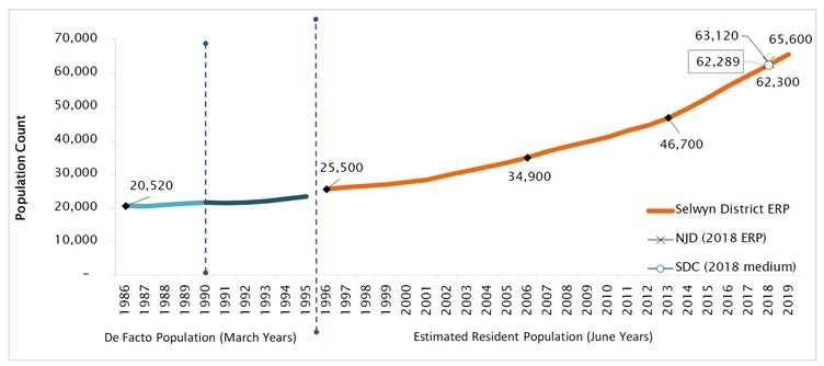
Figure 6‑1 Population Size and Growth, 1986-2021, Selwyn District [12],
Most of Selwyn's population gains have been driven by regional migration. In recent years this has accounted for over 80% of total growth. Figure 6-2 shows the growth from migration. The majority of this growth (around 70%) is coming from Christchurch City. Regional migrants are on average younger than the current population and are seeking safe and modern housing on the city fringe. This increases the workforce population and leads to higher natural increase. Further, comparatively high natural increase, compared to the rest of the country, has also occurred, indicating that the internal net migration is of people wanting to start a family. Recent large projects undertaken by the Government and Council are largely in response to this growth, including schools, parks and other services.
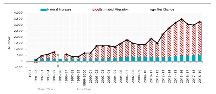
Figure 6‑2 Observed Components of Change
As
the population grows, it is important to see in which demographics the changes are occurring. The following figure shows the percentage change in age groups between 2006 and 2018. The unshaded sections are 2006 and shaded bars are 2018. This figure shows that some ages have decreased in terms of percentage of overall population and some have increased. The decreases are between 30 and 50 year olds and some under 19 year olds, while the bigger increases are 65 to 75 year olds.
Selwyn generally has a younger age structure than New Zealand and is the third-youngest territorial authority in the country. Further, there is evidence to suggest that Selwyn is experiencing 'ageing-in-place', which will lead to a greater level of over 70 year olds in the district, with more retirement villages and over-60 developments occurring.
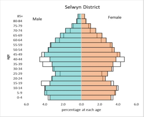
Figure 6‑3 Selwyn District Demographic Changes (2006 – 2018), Selwyn District
Source: Natalie Jackson Demographics (2020) Selwyn – Review of Demographics (Part B)
There are a high proportion of commuters, especially to Christchurch City. This trend is expected to continue as transportation links between Christchurch and Rolleston improve.
6.1.1 Council Model for Selwyn District Growth
Population, household, and dwelling projections underpin the growth model. The model is developed and maintained by Market Economics. The model forecasts household growth in terms of dwelling and employment. The model provides various household projections as inputs and then spatially identifies available capacity within the district. Capacity in the district is based on historic trends of development though can be based on what the District Plan enables. The projections are allocated based on recent take-up trends and then, once township capacity is reached, allocated to other townships.
For the Long Term Plan (LTP), the projections are constrained to available or likely to be available land within the district. This is calculated using site-by-site spatial analysis and the application of the District Plan provisions. For the Infrastructure Strategy's 30 year projection, an unconstrained strategic approach was used where current trends in development were adjusted by broad strategic growth trends creating demand for townships. This may not be able to be catered for within current boundaries and leads to more strategic planning needed.
6.1.2 Growth - Our Space 2018 - 2048
Our Space builds on the growth detailed in the LURP, UDS, Regional Policy Statement PC1 and Selwyn District Plan policies and Land Use Zoning. Our Space coordinates growth within Greater Christchurch setting Medium and Long Term growth minimum targets for the territorial authorities.
It is assumed Council will be able to provide sufficient controls on development, and establish any essential strategic infrastructure (as agreed) to facilitate the implementation of Our Space and in accordance with the Regional Policy Statement and national direction on urban development (e.g. National Policy Statement on Urban Development Capacity).
There is a risk that development will be disconnected and/or at a rate faster or slower than expected. If development takes unexpected patterns, or becomes disjointed, the Council will need to review and revise its capital works programmes.
It will also need to revise operations and maintenance budgets and renewals programmes to suit unpredicted demand and disconnected development.
Achieving coordinated development in “brownfield" areas can also be problematic as dealing with multiple landowners with varying degrees of expectations increases the complexity and potentially, the cost of development. The Council will need to continue to work on providing for infill and intensification in appropriate locations.
As with population projections, frameworks and actions to address growth are reliant on many factors and assumptions. The size and rate of growth will remain considerable factors that Council has little control over.
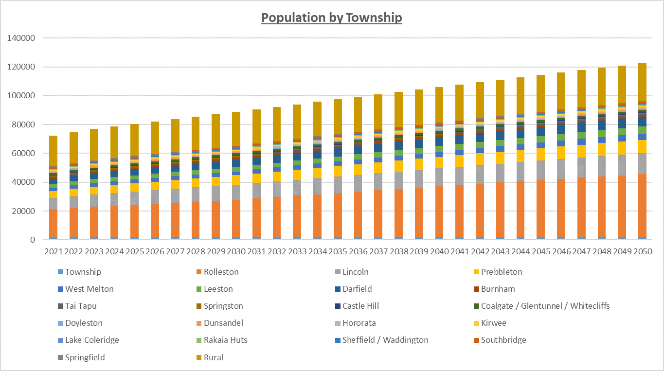
Figure 6‑4 Selwyn Population Growth Projections - Population by Township
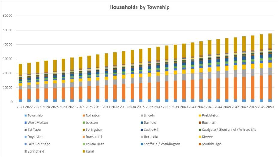
Figure 6‑5 Selwyn Population Growth Projections - Households by Township
The proportion of growth (percentage annual growth) for District Townships over the period 2021 to 2031 is shown in the figure below.
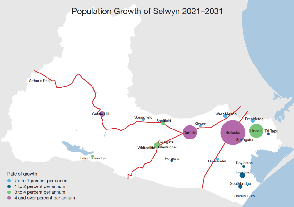
Figure 6‑6 Selwyn Populations Growth Projections
The proportion of growth (percentage annual growth) for District Townships over the period 2031 to 2051 is shown in the figure below.
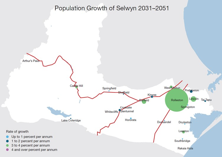
Figure 6‑7 Selwyn Populations Growth Projections
6.2 Greater Christchurch Urban Development Strategy (UDS) - Background and effects
The Greater Christchurch Urban Development Strategy (UDS) has a significant influence on Selwyn District Council's planning and actions. The UDS area includes the Springs and Selwyn Central Wards of the District.
The Greater Christchurch Urban Development Strategy (the Strategy) is a bold and ambitious plan for managing urban development that protects water, enhances open spaces, improves transport links, creates more liveable centres and manages population growth in a sustainable way.
The Strategy vision is for a greater Christchurch for the residents of the area (living south of the Ashley River and north of the Selwyn River) and the Strategy partners, Environment Canterbury, the Christchurch City Council, Selwyn and Waimakariri District Councils and the New Zealand Transport Agency (formerly Transit New Zealand).
The Strategy provides the primary strategic direction for the Greater Christchurch area, including the location of future housing, development of social and retail activity centres, areas for new employment and integration with transport networks. It also establishes a basis for all organisations, not just the Strategy partners, and the community to work collaboratively to manage growth.
The Strategy was created through a three-year long consultation and development process initiated in 2004 due to rising concerns over the lack of collaborative planning and leadership to manage growth in the area in a sustainable way. Community consultation undertaken by the Strategy partners resulted in over 3,250 submissions on growth management options for the area
In 2016 the strategy was revised to align with post-earthquake priorities and legislation. The key changes were the establishment of new guiding principles and strategic goals. This led to new implementation methods and the support of the “Resilient Greater Christchurch Plan". The actions have been updated, with SDC having a role as UDS partner.


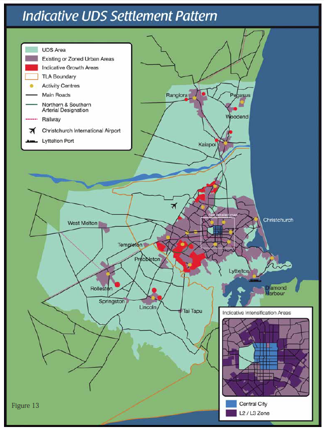
Figure 6‑8 Indicative UDS Settlement Pattern
6.3 Regional Policy Statement Proposed Change 1 (Urban Development Strategy)
Proposed Change 1 was developed to address land use and urban growth management in Greater Christchurch until 2041. It introduced a new Chapter 12A (Development of Greater Christchurch) to the Regional Policy Statement which sets out the land use distribution, household densities for various areas, and other key components for consolidated and integrated urban development. It also sets out which land is to remain rural for natural resource protection or for other reasons.
The Minister for Canterbury Earthquake Recovery, Hon Gerry Brownlee, decided to revoke Proposed Change 1 to the Canterbury Regional Policy Statement. The decision was ancillary to the decision to insert the new Chapter 6 – Recovery and Rebuilding of Greater Christchurch into the Regional Policy Statement as a result of the approval of the Land Use Recovery Plan.
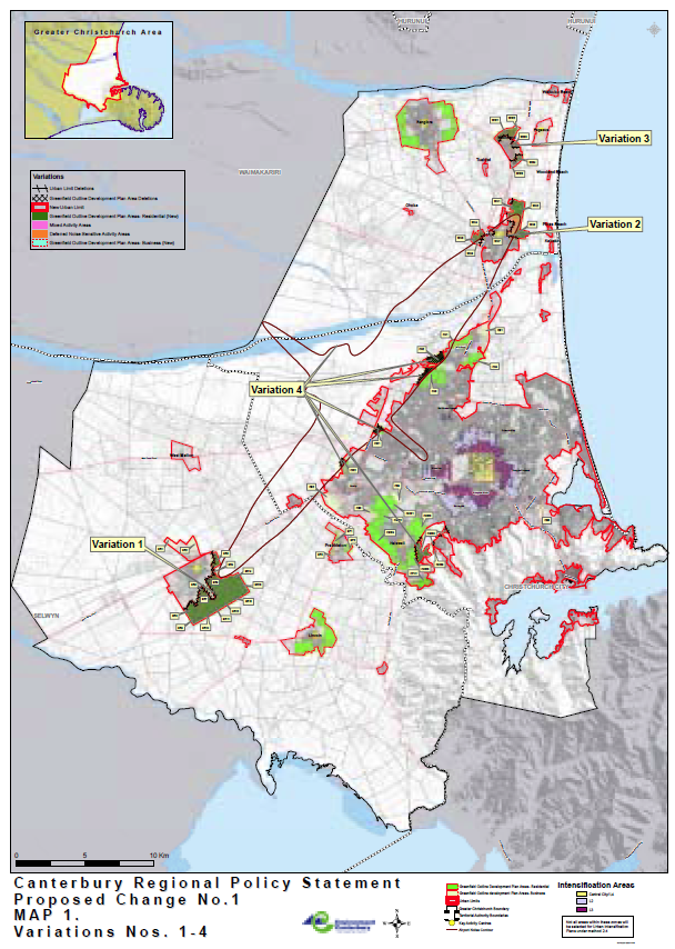
Figure 6‑9 Canterbury Regional Policy Statement Proposed Change No.1
6.4 Land Use Recovery Plan (LURP)
The Land Use Recovery Plan took effect in December 2013. It is a statutory document, and directs the Christchurch City Council, Waimakariri and Selwyn District Councils and Canterbury Regional Council (Environment Canterbury) to make changes to district plans, the Canterbury Regional Policy Statement and other instruments. Some of these changes take effect immediately and others are to be developed by the relevant council within specified timeframes.
In particular, the Land Use Recovery Plan addresses:
- The location and mix of residential and business activities;
- Priority areas for residential and business land development;
- Ways to provide for a range of housing types, including social and affordable housing;
- Ways to support recovery and rebuilding of central city, suburban and town centres; and
- Ways to support delivery of infrastructure and transport networks to serve the priority areas.
Action 18(i) to (vii) identifies seven greenfield priority areas for future residential development.
The Council has developed Outline Development Plans (ODPs) with associated text amendments through an extensive consultation process with landowners, affected parties and stakeholders.
The ODPs have been developed in accordance with best practice urban design and subdivision criteria and will facilitate the provision of up to 4,500 additional residential sections in the Selwyn District.
Accordingly, the Land Use Recovery Plan has considerable influence on the scale and pattern of growth in Selwyn District in the immediate timeframe.
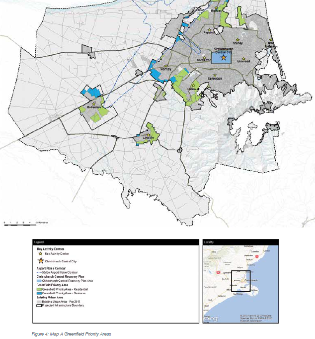
Figure 6‑10 UDS Greenfields Priority Areas
There are specific actions required by SDC to support the implementation of the LURP.
Action 6: Selwyn District Plan
Selwyn District Council is directed, pursuant to section 24(1)(c) of the CER Act, to change or vary the objectives, policies and methods of its district plan to the extent necessary to identify appropriate sites, including brownfield sites, within the existing urban area for intensified residential and mixed-use development and enable comprehensive development of these sites.
Action 13: Selwyn District Plan
Selwyn District Council is directed, pursuant to section 24(1)(c) of the CER Act, to change or vary the objectives, policies and methods of its district plan to the extent necessary to enable a range of community facilities within key activity centres.
Action 17: Immediate amendments to the Selwyn District Plan
Selwyn District Council is directed, pursuant to section 24(1)(a) and (b) of the CER Act, to amend its district plan to include the zoning and outline development plan provisions set out in Appendix 4 (Amendment 1 and 4) for the following greenfield priority areas:
i. Living Z and Living 1A – Prebbleton
ii. Living Z – Rolleston
iii. Living Z – Lincoln
Action 18: Selwyn District Plan
Selwyn District Council is directed, pursuant to section 24(1)(c) of the CER Act, to amend its district plan to the extent necessary to include zoning and outline development plans in accordance with chapter 6 of the Regional Policy Statement for the following greenfield priority areas shown on map A, Appendix 1:
i. ODP Area 4 – Rolleston
ii. ODP Area 9 – Helpet Park
iii. ODP Area 10 – East Maddisons/Goulds Road
iv. ODP Area 11 – Branthwaite Drive
v. ODP Area 12 – Dunns Crossing Road (existing Living zone)
vi. ODP Area 13 – Springston Rolleston/Dynes Road (existing Living zone)
vii. ODP Area 3 – Prebbleton
viii. Implementation of SDC rural residential development strategy.
Action 27: Selwyn District Plan
Selwyn District Council is directed, pursuant to section 24(1)(c) of the CER Act, to change or vary the objectives, policies and methods of its district plan to the extent necessary to provide for:
Rebuilding of existing business areas
i. comprehensive developments in existing urban business areas, including brownfield sites
Rebuilding of centres
ii. zoning that defines the extent of each key activity centre
iii. implementation of the Rolleston Town Centre Masterplan
Greenfield priority areas for business
iv. greenfield priority areas for business at Lincoln and Rolleston shown on map A, appendix 1
v. rezoning of other greenfield priority areas for business shown on map A, appendix 1
vi. thresholds for commercial activities in greenfield priority areas where these are considered necessary to avoid reverse sensitivity effects or effects on the viability of key activity centres.
Action 29: Selwyn District Council Town Centre Development
Selwyn District Council to find ways to overcome barriers to implementing the Rolleston Town Centre Masterplan, including the need to modify or cancel existing resource consents relating to land within the Rolleston Town Centre study area. A request by Selwyn District Council may be made to the Minister for Canterbury Earthquake Recovery to use interventions under the CER Act to overcome barriers to addressing recovery and rebuilding issues that cannot be resolved through usual processes.
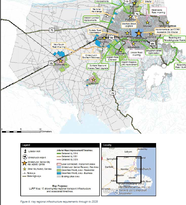
Figure 6‑11 UDS Key Regional Infrastructure requirements
Action 35: Selwyn District Council's prioritised infrastructure programmes
Selwyn District Council, pursuant to section 26(4) of the CER Act, must amend Local Government Act instruments to the extent necessary to provide for prioritised infrastructure programmes that identify capacity requirements and optimise available resources and funding to support the development of greenfield priority residential and business areas, key activity centres, neighbourhood centres, and intensification and brownfield areas.
6.5 Selwyn Housing Accord/Special Housing Areas
The Housing Accord and Special Housing Areas Act was introduced in 2013. The purpose of the legislation is to enhance housing affordability by facilitating an increase in land and housing supply in certain regions or districts, that have been identified as having housing supply and affordability issues. Selwyn District was added to Schedule listing such areas 2015.
Once a Housing Accord is entered into, the next step is for special housing areas to be identified through an order in council. Application for complying development areas could be made and assessed against the Housing Accord's criteria.
The process:
1. Minister identifies district with significant housing affordability and Land supply issues
2. Order in Council adds district to Schedule 1 of the Act
3. Minister negotiates housing accord with council
4. Council proposes special housing areas
5. Minister assesses council's proposal
6. Order in Council declares special housing area
7. More permissive and fast-tracked consent processes can be used
Selwyn District Council signed a Housing Accord with Government in December of 2015.
Potential capacity has been supplemented by way of the Land Use Recovery Plan (LURP), which has created six more growth areas which have a theoretical capacity of 4500 dwellings. The Selwyn District Plan anticipates the development of all these areas in accordance with Outline Development Plans. There has been very limited development to date in these areas due to fragmented land ownership, high land values and high numbers of 'lifestyle' properties with some owners unwilling to aggregate or sell their land.
While in the fullness of time some of this land may be expected to be developed, it is unlikely in the foreseeable future. As such, in the next few years there is likely to be a land supply shortage in Rolleston. This could reduce the affordability of remaining sections in growth areas.
This Accord seeks to contribute to improved affordability by increasing the supply of land in Selwyn, with a focus on Rolleston in particular. It will also ensure that a proportion of new housing supply created is affordable.

Figure 6‑12 Rolleston Special Housing Areas
6.6 District Plan Review
The Resource Management Act 1991 (RMA) requires all operative provisions of a plan to be reviewed every 10 years.
The current Operative Selwyn District Plan was notified in two volumes (Rural Volume in 2000 and Township Volume in 2001) and remains in this two-volume format. While the Plan has yet to be made fully operative, there are large parts of the Plan that have not changed since 2004 when decisions on submissions were released.
The Council is undertaking a full review of the District Plan with the draft Plan notified in October 2020 and submission closing in December 2020 and staff are working through the submissions received to create a summary of the decisions requested by submitters. The summary will be made publicly available in early 2021.
Figure 6‑13 Selwyn District Plan Review Process
The District Plan review process will consider submissions on land to accommodate population and business growth and the process will ultimately determine which land will be available for future growth. This will consider the requirements of the Regional Policy Statement (RPS) in terms of growth allocated to Selwyn District.
Currently there is an opportunity under the National Policy Statement for Urban Capacity for Council to consider plan changes to unlock land for residential development. This situation has resulted in a plethora of plan change applications to change the zoning to enable residential development especially in the growth towns. How these plan changes will be handled and proceed alongside the District Plan review process is yet to be confirmed.
The Resource Management Act 1991 (RMA) requires all operative provisions of a plan to be reviewed every 10 years.
The current Selwyn District Plan was notified in two volumes (Rural Volume in 2000 and Township Volume in 2001) and remains in this two-volume format. While the Plan has yet to be made fully operative, there are large parts of the Plan that have not changed since 2004 when decisions on submissions were released. It is therefore timely to undertake a holistic appraisal of how to improve the Plan, with the aim of the review to produce a 'second generation' District Plan.
At a broad level, it is recognised that the existing District Plan has become unwieldy, with a total of 1500 pages and an excessive number of zones and appendices, including zones within appendices. A number of plan changes have also lead to various approaches to different issues within the Plan, most notably being the way in which urban growth is managed within and outside the Greater Christchurch area. In addition, the resource consent team have identified a range of issues in administering specific parts of the Plan that could be improved through a District Plan Review.
The Council agreed to undertake a full review of the District Plan as a matter of priority at a Council meeting held on 27 May 2015. The District Plan review is expected to take three to four years, but this will be longer if there are complex submissions to work through.
Alignment of the District Plan Review and LTP processes has been pursued where possible. For 2018, the LTP will use 'Community Outcomes,' while the 2021 LTP may align more closely with the objectives in the District Plan to reflect the aspirations of the community for the district.
6.7 Influences on Growth and Demand (District and Community)
There are a number of issues that influence demand forecasting and the associated development improvements. These issues include:
Local population trends;
Accuracy of predicted future populations;
Local economic trends and the diversity of industries;
Changing technology;
Changing legislation requirements; and
Changing community service requirements.
Particular trends that have a significant impact on the 5Waters Activity include:
Growth of the satellite townships closer to Christchurch, such as Rolleston, Lincoln and Prebbleton. The growth predictions and patterns of these townships are encompassed in the Greater Christchurch Urban Development Strategy (UDS), which promotes the sustainable growth of this part of the greater Christchurch area to 2041.
Proposed Plan Change 7 provides for the strategic residential growth around townships within the Greater Christchurch Area, including Rolleston, Lincoln, Prebbleton and West Melton. It is a key method for giving effect to Proposed Change 1 (PC1) to the Regional Policy Statement in Selwyn. The broad objective and policy framework put in place by the Plan Change will manage business and well as residential growth, however the zoning of specific blocks of land primarily relates to new residential development areas around each of the existing townships. Outline Development Plans (ODPs) have been developed for inclusion into the District Plan as part of the plan change process. These seek from the outset to achieve good urban design and sustainable outcomes by establishing how each block will spatially develop across all infrastructural assets, and how these developments will link to existing and other new areas. One of the key elements required to be shown on the ODPs are roading, walking and cycling routes and networks. Plan Change 7 is rezoning over 600ha of Greenfields land and has a requirement to achieve a minimum net density of 10 households per hectare under PC1. It is expected that nearly 12,000 new households will result by 2041 under current growth predictions.
Central Plains Irrigation Scheme – The ongoing development of this integrated water supply scheme to irrigate the central plains area of the District has the aim of increasing agricultural production.
6.8 Economic Trends
The main industry groups in the district are agriculture, tourism and education and research.
6.8.1 Agriculture
Farming has and is expected to continue to have, a significant impact on the District's economy, with a number of district towns being service centres for the rural community. One of Council's objectives is to ensure that this industry will not be adversely affected by changes in Council policy and planning requirements.
Farming in the District has responded to climatic and trade uncertainties in recent years by diversifying and, in some cases, subdividing and selling land for residential development. As a result dairying, deer farming and residential development have increased while sheep farming has declined. Viticulture and olive growing are also expanding in response to the more Mediterranean climatic conditions of recent years (hot summers, mild winters).
Synlait
In 2008, Synlait opened a new dairy factory outside Dunsandel. The Synlait Milk facility processes more than 550 million litres of milk each year. It is capable of processing 3.2 million litres of raw milk per day, from which up to 340 metric tonnes of milk powder can be produced along with other high-value functional ingredients.
Fonterra
In 2012 Fonterra opened a new milk processing plant, located on SH 73 just west of Darfield.
Darfield produces regular and instant whole milk powder. At full steam, it processes 7.2 million litres of milk per day, adding up to an annual production of 220,000 tonnes. The facility employs more than 230 staff and involves a fleet of 37 tankers.
Westland Milk Products
Westland Milk Products is New Zealand's second biggest dairy co-operative, and has a production facility in Rolleston.
In 2015 the West Coast's dairy co-operative ramped up its Canterbury presence by building a $40 million plant to make long-life milk at Rolleston. The plant's development relates to the company's first venture into retail-ready liquid milk at the Izone industrial park. The long-life product is known as UHT milk for its ultra-high temperature processing, and usually has a shelf life of six to nine months. Commercial production from the plant is capable of packing more than 50 million litres of UHT milk and cream a year. The product is sold into China's UHT market, where returns are high and growth prospects are strong.
6.8.2 Tourism
Tourism is a significant industry supported and encouraged by the Council. Tourist numbers have continued to grow nationally and within the Canterbury region. The growing trend to independent travellers has become more common in recent years.
A number of the small settlements such as Arthurs Pass, Rakaia, Castle Hill, and Lake Coleridge are popular places for holiday homes and recreational facilities. Arthurs Pass, Darfield and Springfield in particular support summer and winter-sports in the Craigieburn Basin, Arthurs Pass National Park, Lake Coleridge, the Rakaia Basin and Mt Hutt. These settlements also service long-distance traffic and provide tourist facilities on main tourist routes.
The Council plans to improve tourist facilities in these areas to encourage tourism. Route 72, the Inland Scenic Route provides an inter-district connection between tourism and recreational facilities in Selwyn and those in the adjoining Ashburton and Waimakariri Districts and beyond to the Mackenzie Basin / Mt Cook and Hanmer Springs / Kaikoura. It offers an increasingly attractive, and some times more direct, alternative to the utilitarian State Highway 1. These tourist facilities are supplemented by the major golf course and other recreational and visitor facilities at Terrace Downs.
6.8.3 Higher Education and Research
Lincoln University is located on the outskirts of Lincoln Township. Education and Research Institutes located around Lincoln provide significant employment, in the District and Lincoln is widely regarded as a centre of excellence in agricultural and related research industry.
The crown research institutes located at Lincoln include AgResearch, Landcare Research, plant & food research.
The Council in a joint venture with Lincoln University, Canesis (formerly the Wool Research Organisation of New Zealand (WRONZ), and the Crown Research Institutes aim to promote and develop the current research/ education base in Lincoln. This will be called the 'Lincoln Hub'.
The overarching goal of the Lincoln Hub is to accelerate the rate of economic development of the land-based sectors while improving their environmental performance. In doing so, the Hub will become a globally-significant centre for education, research, technology transfer and adoption, and practice change. By supporting industry innovation, the Hub will help build the capability needed for the primary sectors to achieve their potential. To achieve this, the Hub will be fully integrated into the strategies of the primary industries, and stimulate innovation and entrepreneurial endeavour by the private sector. It will also draw on and connect with other successful Hubs from across New Zealand and the world.
6.8.4 Izone
In 2000 the Council looked to attract new commercial and industry ventures to the district. This prompted the development of the Rolleston Industrial Park (IZONE), which has been established to promote and provide for this type of activity and growth. In recent years development has expanded beyond Izone, with a wider Rolleston Industrial Zone becoming established. Izone is now one of the larger industrial parks in New Zealand.
Covering 188 hectares, Izone has land developed, zoned and ready to bring services and infrastructure into development. The fully master-planned, greenfield site is currently home to more than 70 companies involved mostly in manufacturing, warehousing and logistics, and servicing Canterbury's significant agricultural sector.
The development's ownership by Selwyn District Council ensures affordable land prices, low annual rates, and favourable district plan rules. These include: no development levies, no maximum site cover, and no restrictions on the generation of traffic movements.
As it stands Izone Industrial Park has the potential to grow to over 459 hectares.
Figure 6‑14 Izone Industrial Park
6.8.5 Other Industries
Other industries that provide a varied source of employment in the district include:
- Commercial and Industrial (e.g. The Warehouse's distribution centre)
- Golf Courses e.g. Terrace Downs
- Department of Corrections facilities
- Hospitals
- Forestry, e.g. Selwyn Plantation Board
- Dairying
- Lake Coleridge Hydro Scheme
- NZ Defence Force (Burnham Military Camp)
- Various Small to Medium industry e.g. Meadow Mushrooms
Some of these industries have a lesser effect on the district's overall economy, but are important for providing a variety of employment opportunities within Selwyn.
6.8.6 Employment
The rapid growth in Selwyn District is underpinned by strong employment opportunities. Originally these have been in the agricultural sector, Lincoln University and research centres, as well as commuting to Christchurch City. The Izone development and other initiatives have meant there are considerable opportunities within the district. Izone is the only industrial hub in New Zealand to have a dedicated staff recruitment website. Enterprise Recruitment is Izone's talent gateway. This free service allows Izone companies to advertise job vacancies and provides those looking to move to Selwyn with appropriate information about life in the district. Eventually Enterprise Recruitment will advertise jobs throughout the district and become the talent gateway to Selwyn.
The 2013 census shows employment in agriculture and forestry employ the largest number of workers, followed by manufacturing and construction.
Figure 6‑15 Selwyn District Sources of employment (2013 Census)
6.8.6.1 Work
The most common occupational group in Selwyn District is 'managers', and 'professionals' is the most common occupational group in New Zealand.
The unemployment rate in Selwyn District (total population aged 15 years and over) is 2.2% for people aged 15 years and over, compared with 4% for all of New Zealand.
Figure 6‑16 Selwyn District Occupation Groups

Figure 6‑17 Occupation for employed people aged 15 years and over (Selwyn District and New Zealand, 2013 Census)
6.8.6.2 Income
For people aged 15 years and over, the median income (half earn more, and half earn less, than this amount), in Selwyn District is $42,700. This compares with a median of $31,800 for all of New Zealand.
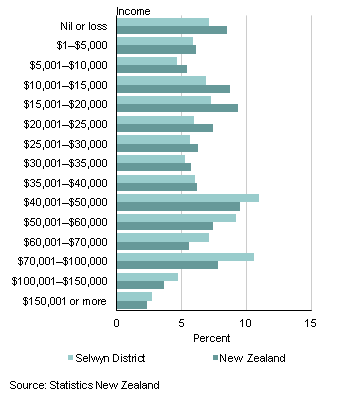
Figure 6‑18 Total personal income for people aged 15 years and over (Selwyn District and New Zealand 2013 Census)
6.8.7 Business demographics
Business demographic data for the year ended February 2013 showed that:
There were 5,524 business locations (geographic units) in Selwyn District compared with 507,908 for all of New Zealand. This is an increase of 9.3% from the year ended February 2006 for Selwyn District.
There were 14,800 paid employees in Selwyn District compared with 1,941,040 for all New Zealand. This is an increase of 28.2% from the year ended February 2006 for Selwyn District.
Table 6‑2 Top Five Industries in Selwyn
Industry (ANZSIC06)(1)
| Selwyn District
| New Zealand
|
Employee count
| Percent of total employee count | Employee count | Percent of total employee count |
Agriculture, forestry and fishing
| 2,770
| 18.7
| 111,520
| 5.7
|
| Public administration and safety | 2,260 | 15.3
| 110,900 | 5.7 |
| Education and training | 1,840 | 12.4 | 167,240 | 8.6 |
| Manufacturing | 1,450 | 9.8 | 211,710 | 10.9 |
| Construction | 1,380 | 9.3
| 124,870 | 6.4 |
(1) Australian and New Zealand Standard Industrial Classification 2006 (ANZSIC06 V1.0).
Note: Some regions, territorial authorities, and local boards may have more than one industry with the same employee count but the table has been restricted to five industries.
6.8.8 Impact on Infrastructure Planning
The on-going and rapid growth in Selwyn District is reliant on core infrastructure. This includes transportation for the movement of freight and people, utilities and waste management to meet the basic needs of industry and the community; and the provision of community facilities that attract and retain people. Rapid growth is a challenge that requires a timely response to ensure the provision of infrastructure is not lagging behind the demand, creating dissatisfaction within the community.
With low levels of employment and a high number of commuters it is important that the district remains attractive and a community of choice. This is partly determined by the services provided by Council, and along with 'essential services' there is a key role for community facilities in attracting and retaining residents.
6.9 Development Contributions
Development contributions are contributions required from developers to help offset the effects of growth they have induced on the network. They are levied under the Local Government Act 2002.
Financial contributions are amounts or works required of developers to avoid, remedy or mitigate the adverse effects of their developments on the environment, built or natural. They are levied under the Resource Management Act 1991
The relationship between capacity, growth, levels of service, and the delivered-capacity of new works is shown diagrammatically below in Figure 6‑25.

Figure 6‑19 Service Delivery Shares
Works that include a growth component can be considered for a development contribution – based on the cost of providing additional capacity for growth. Providing additional capacity for an enhanced level of service as well, shown here as the higher of the two sloping lines, may still attract a growth component but it will be of a lesser proportion.
The Selwyn District Council Development Contributions Policy was adopted by the Council June 2020.
The Policy details the Purpose of Development Contributions as follows:
The purpose of development contributions is to enable territorial authorities to recover from those persons undertaking development a fair, equitable, and proportionate portion of the total cost of capital expenditure necessary to service growth over the long term. Council in preparing this policy has complied with the purpose of the Local Government Act 2002.
In general, a development contribution may be required in relation to a development when:
- The effect of that development requires the Council to construct new or additional assets or assets of increased capacity for any network infrastructure, reserves or community infrastructure; and
- As a consequence, the Council incurs capital expenditure to provide appropriately for network infrastructure, reserves and community infrastructure.
The effect of development in terms of the impact on assets includes the cumulative effect that a development may have in combination with another development. A Development Contributions Policy also enables the Council to require a development contribution that is used to pay, in full or in part, for capital expenditure already incurred by the Council in anticipation of development.
The Council will not require a development contribution for network infrastructure, reserves or community infrastructure in the following cases:
- Where it has, under section 108(2)(a) of the Resource Management Act, imposed a condition on a resource consent requiring that a financial contribution be made in relation to the same development for the same purpose; or
- Where the developer will fund or otherwise provide for the same reserve, network infrastructure, or community facilities; or
- Where it has received or will receive funding from a third party for the same purpose.
The balance of the Policy details the calculation and administration of development contributions respective to: Water and Sewerage, Stormwater, Transportation and Reserves.
6.10 Demand Management
Demand management has a slightly different meaning for each of the 5Water activities provided, but overall it can be taken to mean 'demand for the provision of a service, whether that is the supply of water (including potable and stockwater), or the removal of wastewater (including stormwater and land drainage)'. Increasing demand for a service typically requires additional capital investment and the use of additional resources. If increased demands cannot be accommodated, then a decline in level of service will be experienced (e.g. low water pressure, sewer overflows)
The use of demand management strategies has the benefit of:
- Deferral of capital investment;
- Maintaining levels of service;
- Complying with consenting authorities requirements;
- Reducing operational and maintenance costs;
- Conserving valued resources; and
- Minimising adverse impacts.
Environment Canterbury, as the consenting authority, are requiring water demand management practices to be implemented as part of the requirements of consents and regional plans.
Demand management initiatives will be taken where existing water use is inefficient, or where resource constraints limit the availability of water. The impact of such initiatives will vary depending on the specific measures implemented. Although it is expected that demand management initiatives will see a decreasing per/household demand trend, it is considered prudent to assume that current usage patterns will continue until measurable reductions are evident. The planning impacts of this approach are small, with deferral of capital works the likely outcome.
6.10.1 Demand Impacts on Assets
Population growth is generating increased demand for services within the 5Waters activities. For example, increasing water demand is resulting in limited or insufficient water to meet peak demand particularly in dry or hot summer periods. In addressing security of supply and increasing demand, there is the choice of building additional capacity and creating new infrastructure, or alternatively taking action to both manage and reduce demand through a range or combination of demand management strategies. Timely provision of sustainable infrastructure and the impacts of climate change on Councils assets is discussed in Section 8.0, Infrastructure Sustainability.
There is a tendency to only consider sources of supply when dealing with increasing demand. However, increasing demand also puts a strain on the reticulation network infrastructure that may have insufficient capacity to convey and store, for example the amount of water needed to satisfy demand. This justifies the pursuit of demand management strategies. A demand management strategy reflecting the current situation is now required if difficulties in meeting demand and additional infrastructure expenditure are to be avoided or deferred.
6.10.2 Demand Management Plan
Demand management can be applied across all of the 5Waters activities however, in the past Council has implemented demand management strategies predominately for water supplies. A Water Conservation and Demand Management Plan was developed in 2016, this is further discussed below in Section 6.9.11.
An overarching demand management strategy has yet to be developed for the 5Waters activities, this is listed as an improvement item for 2020/21.
6.10.2.1 Water Demand Management
In 2016 a Water Conservation and Demand Management Plan was developed. This plan reflects a growing awareness of the need for sustainable and efficient use of natural water resources.
As a provider of Water Services, Council has an obligation to the community to provide safe and wholesome water for drinking and sanitation. The objective of the plan is to:
- Provide an overview of Selwyn District Council's current water demand management practices;
- To provide a strategy for water demand management;
- Efficiently manage the demand for water by users;
- Identify where there are opportunities to improve our understanding of how much water we supply to our customers and when; and
- Provide improvements to water management initiatives.
The plan outlines business as usual water conservation and demand management actions, these are:
- Measurement and understanding of current average and peak water usage
- Deliver education and information to the community to implement water conservation
- Implement water restrictions where required
- Maintain growth projections and carry out master planning
- Implementation of mechanisms such as the Water Supply Bylaw 2008 and the Proposed District Plan to encourage and promote efficient use of water
- Management of asset lifecycle to minimise water losses
- Conducting regular review of the water balance and benchmarking against other municipal suppliers
Further to these additional actions were identified to enable future improvements in water demand management, these are outlined in Table 6‑3 below.
Table 6‑3 Improvement Actions
1
| District wide water metering and demand analysis
| High
|
Ensures customers place a value on clean fresh water by incentivising low water use, and efficiency of water use. Provides a fair and equable rating system for low and high water users. |
|
2 |
Water education programme on low water demand gardening | High
|
Provides guidance to existing and new residences, on the unique dry environment in the Selwyn District. This enables appropriate plantings and garden watering practices. |
|
3 |
Targeted Water Audits | Medium |
Reduce daily and peak demand by working with high water users to reduce demand.
|
|
4 |
Review drought management plan | Medium |
Review management of water supplies with staff and contractors following periods of dry weather to confirm what worked well and what can be improved. |
|
5 |
Rainwater harvesting feasibility | Medium
|
Investigate the benefits and issues with rainwater harvesting. |
|
6 |
Wastewater re-use and recycling | Low
| Review the option to re-use treated wastewater for irrigation use on Council reserves and gardens. |
Action 1, water metering, has nearly been completed. Water metering enables consumers to place an appropriate value on clean safe water. Table 6‑4 below outlines where water metering exists within the district.
Table 6‑4 Scheme Metering as at March 2021
|
Arthur's Pass | Metered (79%)
|
Leeston | Metered |
|
Castle Hill | Metered (95%)
|
Lincoln | Metered |
|
Claremont | Metered
|
Malvern Hills | Restricted supply |
|
Darfield | metered |
Prebbleton | Metered |
|
Darfield Rural A | Restricted supply |
Rakaia Huts | Metered |
|
Darfield Rural B | Restricted supply |
Raven Drive | Metered |
|
Doyleston | Metered |
Rolleston | Metered |
|
Dunsandel | Metered |
Sheffield/Waddington | Metered |
|
Edendale | Metered |
Southbridge | Metered |
|
Hororata Acheron | Restricted supply |
Springfield | Metered |
|
Johnson Road | Metered |
Springfield - Annat Extension | Restricted supply |
|
Jowers Road | Metered (88%)
|
Springston | Metered |
|
Kirwee | Metered |
Tai Tapu | Metered (89%)
|
|
Kirwee - Courtenay Bealey Exte | Restricted supply |
Tai Tapu Otahuna Valley | Restricted supply |
|
Kirwee - Courtenay Extension | Restricted supply |
Te Pirita | Metered |
|
Lake Coleridge | Metered (95%)
|
West Melton | Metered |
Selwyn District Council’s annual cost in 2020/21 to supply each household with 200 cubic metres of water a year is $354. This is lower than most of our neighbouring districts and below the national average of $454 a year. Our volumetric (metered) rate of $0.50 per cubic metre (1,000 litres) of water is also one of the lowest rates in New Zealand. Water rates are used to pay for the costs of supplying water to households (not for the water itself). Currently residents pay the following types of water rates, depending on whether their water supply connection is restricted or on-demand:
- A fixed annual base rate (paid by all properties connected to a Council water supply). In 2020 this was $254 per year.
- In addition to the fixed rate, there’s also a volumetric (metered) rate for those with unrestricted water supply. This means they pay for the supply of water based on what they use. In 2020 this was $0.50 per cubic metre. Most households receive water on demand.
- In addition to the fixed rate, a rate per water unit (usually 1,000 litres) is charged to those with restricted water supply in our rural areas. In 2020 this was $183 per unit. The daily volume of water supplied to these properties is restricted to a predefined volume.
We are proposing to increase water rates for three reasons:
- The cost of supplying water is increasing as regulations change. We need to collect more revenue to meet the increased costs of providing water.
- Our district uses a lot of water on a per-person basis, and this needs to be managed carefully to ensure we can keep enjoying this resource in the future.
- We want to provide an improved level of service to our ratepayers.
We are now consulting on two options for how we could fund this water rates increase (see table below). Both options are designed to raise similar levels of revenue.
As outlined in the Long-Term Plan 2018–2028, water demand management has become increasingly important to offset the effects of rapid population growth in the district, and to manage our impact on the environment. This continues to be important. Water demand management has multiple benefits, including:
- conserving water and minimising adverse environmental, social, and cultural impacts of water extraction.
- deferring capital investment in water supply, treatment and distribution
- maintaining levels of service (pressure and flow), especially at peak times
- complying with consent limits for water abstraction
- reducing operational and maintenance costs
As part of the 2021 - 31 LTP consulation, Council have proposed two different rate increase options as follows:
Option 1 - Increase the volumetric water rate by a higher proportion than the annual fixed rate, or
Option 2 - Increase both the volumetric water rate and annual fixed rate by the same proportion
Option 1 is Councils preferred option as in it encourages better water management, as water users pay for water supply on the basis of what they use. We think this is a fairer and more environmentally responsible option. This also gives ratepayers more control over their water rates bill – those that use less, pay less.
Water Restrictions
The plan also outlines a peak demand management plan which provides guidance on using water restrictions to manage peak demand. The most effective way to reduce water consumption in times of drought or water shortage is to introduce water restrictions. Water restrictions theoretically allow the water source to be sustained under a variety of usage and drought scenarios. Restrictions will apply to the Selwyn District area including residential, rural restricted areas and commercial/industrial water users.
Table 6‑5 below details levels for restrictions for water supplies under Councils control. Water restrictions can be initiated by the Asset Manager or as delegated to staff.
Table 6‑5 Levels of Water Restrictions
|
Level 1 | -
No watering of lawns is permitted between the hours of 6am to 9am and 4pm to 9pm only
-
Garden watering is permitted
-
There is a requirement to decrease demand especially during peak periods.
|
|
Level 2 |
- Watering of lawns is permitted between 9am-4pm and 9pm-6am on alternate days only.
(Note. If your street address number is even then water on even-numbered days, if your street address number is odd then water on odd-numbered days. For example if your property number is 2, 24b or 108 you can water your lawn as needed on the 8, 10, 12 December and so on during the permitted times. If watering during the daytime we recommend choosing a cooler day to reduce evaporation.) -
Garden watering is permitted.
-
There is a requirement to decrease demand especially during peak periods
|
|
Level 3 | -
No watering of lawns is permitted.
-
Hand garden watering is permitted, total ban on domestic sprinklers
-
There is a requirement to decrease demand
|
|
Level 4 | -
Total ban on all external non-essential use of water
-
Consumers may carry water using a bucket, watering can or similar to maintain plants as necessary
|
The key messages publicised with the water restrictions are:
- Water restrictions are now being introduced.
- Residents in several Selwyn towns are being urged to immediately reduce their water usage at peak times.
- Water consumption is already high and is increasing significantly, mainly from residential water use for garden and lawn watering.
- Water supplies in some locations are struggling to meet demand, in some cases resulting in significant pressure drops and depletion of reservoir storage.
- A range of factors is contributing to the high demand including extreme weather conditions, low river flows, and continuing growth in some residential areas.
- Council is working on improvements to increase capacity for a number of supplies
A water supply planning strategy has been developed for Selwyn water supplies following the implementation of district wide rating. The planning strategy was developed to underpin asset investment decisions, ensuring efficient and effective delivery of water supply services sufficient to meet reasonable community needs across the district. Supplies were broadly classified on the basis of factors including population served, growth, presence of schools and hospitals, presence of commercial activities, supply type. The supply classification reflects the consequence in event of a water supply failure. A range of operating conditions were also considered, as it is recognised that the desired water supply objectives will vary depending on the prevailing conditions. These include: normal operation, impaired operation – minor/major, and emergency operation. The scenario groupings are aligned with the likelihood (or frequency) of an event occurrence that may impact on the supply of water to consumers.
Water loss calculations are also annually undertaken as part of key performance indicators. Using a water balance method Council can identify where water supplied into a water supply distribution network is utilised, and is typically used to establish the level of water loss occurring in a water supply network. This analysis is helpful for managing demand and development of a water loss strategy is included in the improvement plan. This will provide an overall strategy and programme to manage water losses in the district in the long term to agreed acceptable levels.
Council proposes to build a reasonable use model for water consumption. This model will assess how much water is reasonable to use on each property connected to their water supply schemes.
A water supply strategy will be developed which provides a clear direction and summarises information from five key documents:
- Climate Cycles and Trends
- Levels of Service
- Demand Management
- Reasonable Use
- Water Loss
This document will also feed into the revised 5Waters Strategy.
6.10.2.2 Wastewater Demand Management
Wastewater demand management involves implementing strategies to reduce effluent flows and promoting more efficient network operations. These strategies involve altering or repairing the asset to achieve the target.
The Council's future demand management approach will be a continuation of the effluent flow reduction strategies. The hydraulic models that have been developed further strengthen this approach. This will enable the infiltration reduction to be quantified and improved upon.
6.10.2.3 Stormwater Demand Management
Demand management for the stormwater utility is limited to promoting on site stormwater management and limiting the extent of development that contributes stormwater runoff to community systems. This is achieved through District Plan Rules, and potentially through Codes of Practice (Urban).
6.10.2.4 Land Drainage Demand Management
The primary control mechanism available to Council in respect to the drainage systems is to control the areas in which development can occur, and the densities to which it can occur. These controls are implemented through Council's District Plan.
Public education programmes are to be developed to remind the public of the monetary and environmental consequences of inappropriate use of the drainage system.
6.10.2.5 Water Races Demand Management
Limited surface water in rivers and streams during summer drought places added stress on other water uses/values such as fishing, recreation, ecological and cultural values. Extraction of water for Council water race system has potential to place additional pressures on river systems.
A detailed Demand Management Strategy for water races has been developed and is incorporated in the Water Race Management Plan. This considers various strategies for optimising demand, conservation, reducing risk of insufficient capacity, quantifying and reducing water lost through infiltration and overflows.
These strategies are based on the water balance and the ability to obtain the most effectiveness from these strategies .i.e. infiltration accounts for 89% of water used therefore the majority of effort should be directed into this area.
6.10.3 Asset Programs to meet demand
The program for the provision of infrastructure to meet demand is set out in Section 11.0, Financial Summary. This section outlines the funding program for 5Waters activities for the next ten years. The program is split into four types of expenditure where:
-
Expenditure consists of operation and maintenance costs;
-
Renewals are replacement of assets which are nearing or exceeded their useful life;
-
Projects are investigations, decisions and planning activities which exclude capital works; and
-
Capital projects are activities involving physical works.
At a scheme level, these programs are detailed in Volume 2,3,4,5 and 6.
6.11 Water and Sanitary Assessment
Note: This section is an exert from the Water and Sanitary Services Assessment
The Water and Sanitary Services Assessment is an assessment of all services (public and private) relating to:
- Water;
- Wastewater;
- Stormwater;
- Cemeteries; and
- Public Toilets.
The purpose of an assessment under section 125 of the Local Government Act 2002 is to assess, from a public health perspective, the adequacy of water and other sanitary services available to communities within a territorial authority' district. In particular the quality of services, current and estimated future demands, the extent to which drinking water provided by water supply services meets applicable regulatory standards; and the actual or potential consequences of stormwater and sewage discharges within the district.
The last review was undertaken in 2011. Since then the district has experienced significant growth resulting in water and wastewater connections growing exponentially. Large parts of the 2011 review and the original 2006 assessment remain relevant. This review is based on these assessments and provides up-to-date information to reflect the changed circumstances.
This assessment is set out in two main parts. The first part covers the context and principles during the undertaking of this assessment. And the second, covers the assessment of each service area.
6.11.1 Exclusions of the assessment
This assessment focuses on public health matters but it needs to be read in conjunction with other planning documents; including the Long Term Plan, Activity Management Plans and the Demand Management Plan. These documents have a specific purpose and detail each service area in depth. Consequently, this assessment provides a broad overview of each service rather than a detailed description.
It is important to note that the Council does not have responsibility of all areas or aspects of service provision. For example Council is not responsible for the performance of private septic tanks or other private wastewater treatment facilities. However the performance of these facilities can have effects on the wider environment and community perceptions regarding sanitary services. Therefore, although Council is not specifically responsible it must consider whether there is a need for any specific action, such as education, to ensure that the community's health is protected. While the assessment does not describe the performance of the private service provision, it does describe the issues associated with private services and explains the Councils action in relation to matters that are beyond immediate control.
Solid waste management is also excluded from this assessment. The Council have adopted a Waste Minimisation and Management Plan (2011) which is kept under review and managed separately from sanitary services, there are specific legislative requirements for this under the Waste Minimisation Act, 2008.
6.11.2 Impacts of Growth on Water and Sanitary Services
The growth projections indicate that the district will continue to grow. Decisions about the provision of infrastructure and sanitary services over the next 30 years need to take into account these growth patterns.
The likely changes mean:
- Continued growth within the townships provides challenges around timely installation of infrastructure and the ability of industry to meet these demands.
- The building of new houses also creates some short term pressure on water infrastructure (e.g. establishment of new lawns). This is exacerbated by larger sections in townships such as Prebbleton and West Melton.
- The population of Selwyn is relatively youthful, indicating large parents and children cohorts which is why there is a need for new infrastructure such as schools in Rolleston and Lincoln.
- The population is also ageing which means there will be a requirement for different dwellings (e.g. smaller houses and less of a requirement of irrigation of large garden areas).
- Growth in holiday destination towns (e.g. Castle Hill) creates intermittent peaks and visitor expectations (e.g. occupancy during holiday peaks).
- Increased tourist numbers with increasing expectations (e.g. seasonal peaks of visitors seeking experiences).
- Migration from Christchurch City to Selwyn has created changes in public perception and expectations (e.g. residents in rural towns expecting high levels of service).
- The aging demographic and increasing population will result in some increase in demand for burial space and cemetery services over time. There is however, a slight trend towards ashes interment versus plot burial, which will reduce pressure on future land requirement if this trend continues. There is sufficient land available at the current cemeteries (with expansion into existing land at some sites) to meet demand over the next 10 years.
- There is significant increasing demand for public toilets, particularly as a result of tourism and visitor numbers increasing in the district. Other demand drivers include freedom camping, township growth (commercial precincts), sports parks and larger recreation parks. There has been significant investment in construction of new and the upgrade of existing facilities in recent years to address quality and capacity issues. Future works are planned to meet expected demand.
In addition to these trends key sanitary services such as water and wastewater treatment facilities are regulated through consents, some of which will require renewal or replacement over the next 30 years. In addition to this, due to the rapid growth an increasing number of consents are being applied for, particularly for water. The regulatory environment which we are now applying or re-applying for these consents has undergone significant changes in recent years. Higher standards now apply for the renewal of existing consents or proposal of new facilities.
Alongside this there has significant changes to the legislative environment. The introduction of national and regional polices such as the National Policy Statement on Fresh Water Management and the Land and Water Plan has increased consenting requirements and removed previously permitted activities. The outcome of the Havelock North Inquiry has increased water compliance reporting requirements. The Department of Internal Affairs is also currently undertaking a review of the 3 Water Services at a national level.
There is also a greater level of understanding since 2011 of the impacts of climate cycles and trends. Research undertake by the Royal Society of New Zealand (2016) has explored the implications of Climate Change for New Zealand and found that the Australasian region continues to show a long-term trend towards higher surface air and sea surface temperatures, more hot extremes and fewer cold extremes and changed rainfall patterns. At a district level research undertaken by Aqualinc (2016) suggests that by 2046:
- Average temperature will increase by 0.8 degrees
- Evapotranspiration rates will increase by about 3%
- Mean annual rainfall on the Canterbury Plains will stay relatively unchanged
- The number of windy days could increase by 1 to 2%
- Minor impact on groundwater and flows in lowland streams
- Sea levels could rise by a further 0.08-0.23m
These changes will have impacts on the 5Waters assets and management. All of the Councils asset management planning has been based on models and projections of climate changes. These assumptions are being reviewed as part of the ongoing review of asset management plans to ensure that infrastructure is capable of managing the potential events indicated in the latest research.
6.11.3 Service Assessments
6.11.3.1 Water Supply
Council manages 27 water supplies which supply water to approximately 80% of households and businesses within the district. The water supply schemes are located between the main divide (Arthurs Pass) and Pacific Coast (Taumutu). These schemes are described in more detail in the Water Supply Activity Management Plan. The water sources are a mixture of groundwater bores and surface water intakes. Water takes are regulated by consents from Environment Canterbury.
Other properties within the district are serviced by private water sources including bores, surface water and rainwater collection. Selwyn District Council is working to identify and assess private water supplies as part of our preparation for water reform.
The availability of drinking water is important to support the health and well-being of communities. Water quality and quantity are both important. Some areas within the district (primarily rural areas) are serviced by restricted water supplies, requiring water storage and providing a fixed volume of water per day.
Surface water supplies can be susceptible to high turbidity during rainfall events, and are also more vulnerable to changes in flow. Land use activities within the catchment can also influence the quality of water. The majority of water in Selwyn is provided from groundwater sources. Groundwater tends to be less vulnerable to contamination compared to surface water, however there is still the potential for contamination from land-use activities and from poor security around the wellheads. There are also concerns about the quality of groundwater as a result of land-use activities over long time periods, particularly agricultural activities. Over time in Selwyn District, we have seen an increasing number of transgressions in secure wells. This has led to the following assumption in the LTP:
Secure ground water status will be lost over the next ten years on bores located in semi-confined aquifers and bores less than 30m deep in confined aquifers.
The level of nitrates in water bores could also be an issue in Selwyn due to land-use practices, particularly the conversion of farms to dairying. Although no Selwyn wells are currently at high risk from nitrates, we monitor the wells in Dunsandel, Darfield and one in Rolleston (Illinois Drive) monthly due to the requirements under the Drinking Water Standards (once nitrate is measured at over half the maximum acceptable value). Not all bores which belong to SDC are located on SDC land; this creates issues for ensuring the protection of the wellhead.
Houses reliant on roof water are subject to variations in rainfall and in some places, this may not provide an adequate water supply. Periods of low supply could impact on the wellbeing and health of these households. Roof water has the potential for immediate contamination. For example, roofing materials have the ability to attract dust from the atmosphere created from wood burners, fertilisers, and roads. Wildlife such as birds increases the risk of contamination from faeces.
Storage of water also has a significant potential to result in risks to public health. Where communities rely on privately owned tanks or patterns of use are sporadic, this risk is higher. For tanks connected to rainwater systems, first flush systems are necessary to prevent debris from being washed into tanks during a rainfall tank. Unfortunately, the purchase of these systems are not standard practice. Historically tanks were open, i.e. they were not sealed to prevent entry by animals, insects and birds. Also, maintenance of any storage system is critical but is often overlooked until a problem arises. There are many tank-based systems within Selwyn, as any resident connected to a restricted supply (rural schemes or larger residential sections) are required to have a tank. Reservoirs/tanks are also part of the Selwyn water supplies, these tanks are regularly maintained and all sit above ground to limit the ingress of contaminated material.
These households/communities within Selwyn have been identified to have higher risks:
- Private community supplies e.g. Lower Selwyn Huts
- Private Supplies e.g. Properties on private bores
- Institutions e.g. Marae, Lincoln University
- Community halls
- Community Pools
- Campgrounds
- Households using water race water for domestic use
It is noted that Community and Public Health (CPH) do not monitor or regulate private water supplies but if they are over a certain size they must be registered. In future years Council may become responsible for some of these private water supplies, as a consequence of three waters reform.
In the first year of the LTP there is a project to identify all the households that use water race water for domestic use. Although the water races were not designed for a domestic supply it is known that some households use it for domestic purposes.
There has been an increase in tourism in the Selwyn District. This is partly due to the Kaikoura earthquake and the popularity of freedom camping. Often there are over 200 people a night at campgrounds that were not designed for that capacity. Therefore, we are now experiencing issues with having the capability to supply potable water. The water that is provided is separate to Council's water supplies and is not treated, signage indicates this is a non-potable supply. Water supplies with these characteristics may need to be upgraded in future as a consequence of water reform.
6.11.3.2 Wastewater
The Council manages 14 reticulated wastewater systems, the details of these are described in the Wastewater Activity Management Plan. The networks service 63% of the district and have been provided where unsanitary conditions were created through high groundwater conditions, large settlements or the sale of Crown operations to Council that required a reticulated system be provided. The majority of the wastewater is pumped to the Pines Wastewater Treatment Plant in Rolleston or the Ellesmere Treatment Plant in Leeston, with both plants disposing of treated effluent to land. While these networks supply the majority of the district's households, the rest of the district is serviced by septic tanks.
Treatment, disposal and collection of wastewater is important to support the health and well-being of communities. The absence or deficiency of suitable provision can result in communities coming into contact with raw or partially treated wastewater. The health risks of this are significant and could be life-threatening. While the Council provides a service to the majority of the community, large areas and communities are also serviced by private systems.
The Council's network consists of infrastructure and discharges which are subject to resource consents administered by Environment Canterbury. These consents include requirements for regular monitoring and reporting to ensure that the natural environment is protected.
Levels of technical knowledge and skills are required to ensure that private systems are properly installed, maintained and replaced. Failure of private systems may be difficult to detect as there are limited systems in place to ensure comprehensive monitoring and maintenance. This is exacerbated by changes in property ownership and therefore a lack of understanding about the wastewater system. There is therefore a risk that the system could fail and unintended discharges could result. Where these systems only serve one household, the risk is limited, however there is potential to be exposed to raw wastewater. Another issue arises where dwellings are only used for holiday occupancy. Therefore the pattern of wastewater discharge can vary considerably with periods of no use and periods of excessive loading.
Darfield and Kirwee are two of the largest un-sewered communities in New Zealand. In the 2021 - 2031 LTP, Council have consulted publicly on the option of rolling out a reticulated wastewater scheme to these towns. Further detail is provided in Volume 3 - Wastewater.
Council owns two septage disposal facilities which were commissioned during 1996 and decommissioned in 2017. These sites were developed to allow disposal of domestic septic tank sludge for the Darfield and Hororata areas. The Council is currently applying for a consent to remediate the sites. At present there is no septage disposal facilities in the district. The Council is planning to build a septage receiving site at the Pines Wastewater Treatment Plant (in Rolleston) within the 2021 - 2031 LTP period.
Tourism growth in the Selwyn District has included an increase in the popularity of freedom camping. This has resulted in increased use of the district's campgrounds, which are free camping sites with only basic toilet and refuse services. This has resulted in some wastewater issues at campgrounds at peak times. These campgrounds are mostly serviced by septic tanks and/or holding tanks. Water supplies are also generally via an on-site well, so are not tested.
Tourism growth has also seen an increase in the number of campervans to the district and the resulting disposal of self-contained effluent is creating an increasing demand for dump stations. This is currently addressed by the provision of four campervan effluent disposal stations on Council land, plus other private dump points at some service stations. Council has identified the need for increased provision of effluent disposal stations to meet future expected demand. Additional funding has been programmed over the next 10 years for the provision of new stations, although siting is subject to further analysis and has not yet been confirmed.
6.11.3.3 Stormwater
The Council manages 22 stormwater management areas within the district. These areas are all urban in nature and have infrastructure in place to collect, convey and dispose of surface water. Some areas have stormwater treatment devices, though this is not widespread. The diverse geographic location of the stormwater management areas brings with it the need to provide a range of location-specific stormwater management techniques that meet particular community's needs. For example, rainfall, ground water depths and soil types vary across the district and affect stormwater management.
Council helps manage surface water in these urban areas that can lead to risks in public health and safety, damage to property, and contribute to dangerous road conditions. The Council's network consists of infrastructure and discharges which are subject to resource consents granted by Environment Canterbury. Changes under the Land and Water Reginal Planning rules mean that from 2025, Council will be responsible for the quality and quantity of stormwater discharges from their networks.
In 2013 the Council experienced a significant stormwater event, with Leeston being particularly affected. Following this, a public meeting was held during which the community asked the Council to look at options to divert floodwaters from the surrounding land around the township, to manage localised flooding. Drop-in sessions were also held so that individual property owners could talk with Council staff about any issues affecting their property. Following the public meeting, Council worked with the Leeston Community Committee to investigate a number of ideas and suggestions which were discussed at a further community meeting. All ratepayers were then given the opportunity to provide feedback via a questionnaire. 77% of survey forms received voted in favour of work progressing to upgrade the stormwater system. Residents also had the option to vote on which option they preferred. This resulted in the construction of the Leeston bypass, which is currently nearing completion.
The Council has also undertaken 'Rapid Flood Hazard Assessment' modelling for its main townships. The modelling uses DHI MIKE 21 to produce maps illustrating a range of flood depths during different rainfall intensities and durations. These maps are used for planning purposes.
Council is also responsible for managing 10 Land Drainage schemes, including one flood protection scheme (to provide flood protection for Arthurs Pass). The focus of the Land Drainage schemes is to drain groundwater and stormwater from land to ensure land productivity, rather than flood protection.
Elsewhere in the district, stormwater is managed primarily through private onsite soakage pits and private flood protection banks.
6.11.4 Current and Future Demands
Selwyn District is growing rapidly. Council expect that most of this growth will occur on land in the major townships, which is currently unserviced (commonly known as greenfield developments). The district plan outlines where development can be undertaken and requires new developments to be adequately serviced by appropriate infrastructure. This requires developers to install water, wastewater and stormwater reticulation. The developer must assess and design networks that ensure there are no capacity issues and that each lot has a connection to the Council network when available. Water networks must have appropriately sized reticulation to provide adequate pressure for each property and for operation of fire hydrants. Where possible developments are serviced by gravity sewer and developers must show that reticulation has been sized to accept the flow from the contributing catchment. If this cannot be achieved pump stations or a pressurised sewer network can be installed. Stormwater networks vary over the district and will either involve stormwater runoff being discharged to ground or into a Council owned reticulated network. Where treatment is required swale, basins or ponds may need to be installed.
After a year, these developments are vested in Council with the exclusion of pump station and stormwater facilities which have a defects period of two years. Although developers provide the infrastructure, Council oversees this process and work with developers to upgrade infrastructure where required to ensure the network functions efficiently and effectively. Council also undertakes master planning in conjunction with the LTP process to ensure the forecasted growth will not create capacity constraints and therefore the relevant infrastructure is upgraded in time.
If development is located beyond the reach of Council it will still need to make appropriate provision for water, wastewater and stormwater. Proposals designed to service additional communities such as community halls and sports clubs will increase the potential for health risks associated with the provision of water supply, treatment and maintenance; wastewater collection, treatment and discharge; and stormwater discharge.
6.12 Improvement Planning
Throughout this section a number of specific actions to improve the way in which the Council identifies and manages its growth and demand associated with the 5Waters activity. These actions are summarised below in Table 6‑6.
Table 6‑6 AM Improvement Items – Growth and Demand
6.1
| Monitor and revise growth predictions for the district as growth continues
| Medium
| Every 3 years
|
| 6.9.2 | Develop a demand management plan for all 5Water Services | Medium | 2019/20 |
| 6.9.2 | Review the demand management plan for Water | Medium | 2018/19 |
| 6.9.2 | Develop a water loss strategy
| Medium | 2019/20
|
| 6.9.2 | Reasonable Use Model (recognised more appropriately as an improvement item in Section 8) | High | 2018/19
|
| 6.9.2 | Develop a water supply strategy | Medium | 2020/21 |
View citations
<<
5-Waters Volume 1