<<
5-Waters-Volume-4-Stormwater
8 Hororata Stormwater Scheme
8.1 Scheme Summary
Scheme Area
| 290.93ha |
| Scheme Coverage (as at 1 Jan 2021) | Rating numbers | 75
|
System components
| Piped (m) | 760
|
| Swales (m) | 1,440
|
| Drains (m) | 2,802
|
| Manholes/Inspection Chambers (No.) | 2
|
| Treatment | N/A |
| Other | 3 Soakage pits
|
Value ($)
| Replacement Cost | $312,095
|
| Depreciated Replacement Cost | $261,774
|
| Financial | Operator cost (scheduled and reactive maintenance) per connection
| $18.44/connection
|
Planning
| Stormwater Management Plan | Draft
|
| No. SDC stormwater consents | 1
|
Demand
| Mean Annual Rainfall (mm) | 694 |
| 10% AEP (10 year) 1hr rainfall depth (mm) | 16.9 |
| Sustainability | Sustainable drain management practices | Adopted and Encouraged |
8.2 Key Issues
The following key issues are associated with the Hororata Stormwater Scheme. A list of district wide issues are located in 5Waters Activity Management Plan: Volume 1.
Table 8‑1 Hororata Scheme Issues
| Flooding of properties between Bealey and Hawkins Roads originating from natural springs. | Options investigated, continue to liaise with community to determine willingness to pay. |
| Flooding originating from upper catchment impacting on the township | Discuss options with the community to prioritise areas of need and further develop flood relief channel options. |
| Increased expectation from the community regarding level of service received from the stormwater network | Identify capacity restrictions in the system, design upgrades and budget for physical works. |
8.3 Overview & History
The Hororata township predominantly discharges stormwater to a branch of the Hororata River. In addition to the river discharge, there are some discharges to ground. The township is susceptible to flooding from the upper catchment which is conveyed, in part, by a network of abandoned stock water races.
Stormwater is directed to two pits; Scotts Road and in the Domain off Hororata Road. The community has proposed the use of another pit off Hawkins Road. There are known to be springs in parts of the township, which appear days after heavy rain. Under disputes tribunal order July 2010, Council is required to arrange and cover the cost of pumping water from the gardens of 373 and 377 Hawkins Road. The pump is stored at the local fire station, and there is a fuel account at the local garage.
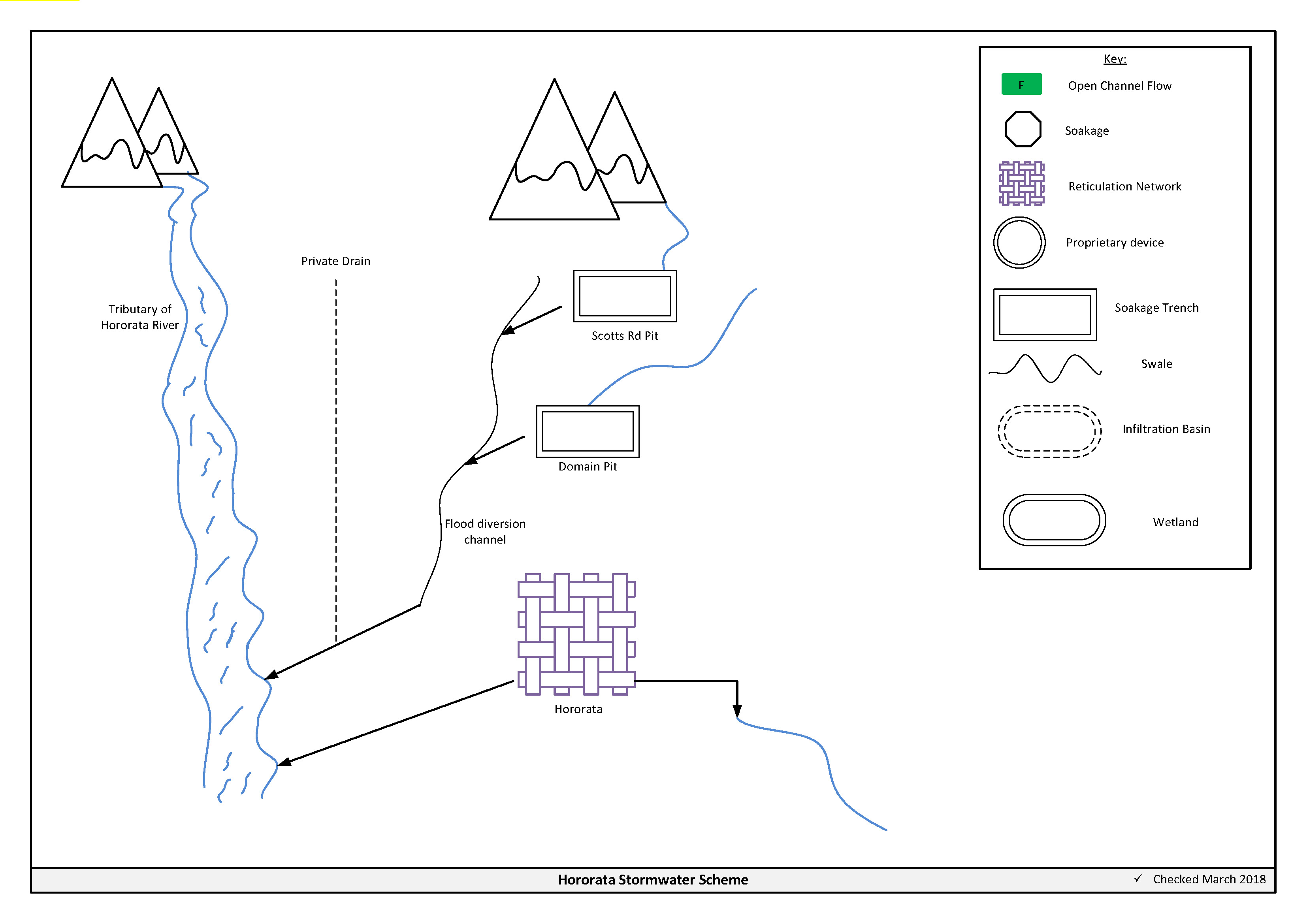
Figure 8‑2 Scheme Schematic
8.4 Resource Consents
Council have applied for a global consent for the Hororata stormwater scheme (CRC167471). The application is underway with ECan.
Table 8‑2 Resource Consents
CRC167471
Application in Process | To discharge stormwater from the existing stormwater network of Hororata | Hororata, Selwyn | | |
8.5 Integrated Stormwater Management Plan
Environment Canterbury's Land and Water Regional Plan became operative on the 13th December 2018. Under policy 4.16, any reticulated stormwater system for an urban area requires a stormwater management plan. Additionally, from 1 January 2025, operators of reticulated stormwater systems will become responsible for the quality and quantity of all stormwater discharged from the reticulated stormwater system. The Hororata stormwater management plan was updated in March 2016 and has been lodged with ECan.
8.6 Scheme Assets
Council has a wide variety of stormwater assets within the district. A brief description of the assets within this scheme is provided below:
a. Flood diversion channel – is a large scale open drain designed to convey flood flows.
b. Reticulated network – Includes pipes, manholes, sumps. The primary purpose of the reticulated network is to collect and convey stormwater. Historically these systems were designed for the 2 year storm event. Today's engineering standards require the piped network to be designed for a 10 year event with overland flow provision for up to the 50 year event.
c. Soakage Pit – these are historic gravel abstraction pits which are used to store and dispose of flood waters.
d. Open drains – are channels used to convey stormwater. They are cost effective means to convey large volumes of water.
A summary of material and diameter for channels and pipes, where known, is shown below in Figure 8‑3 and Figure 8‑4.
Figure 8‑3 Pipe Material - Hororata
Figure 8‑4 Pipe Diameter – Hororata
8.7 Operational Management
The stormwater network is operated and maintained under two maintenance contracts as follows:
- Contract 1241: Water Services Contract. Contract is with SICON who undertakes investigations, conditions inspections, proactive and reactive maintenance and minor asset renewals.
- Contract 1202: Parks and Reserves Contract. Contract is with SICON who undertakes the maintenance of land scape features related to water services e.g. mowing, gardens etc.
Water quality sampling is completed under an agreement with Food and Health Ltd as required.
8.8 Photos of Main Assets
The photos below provide a summary of the types of assets found within this stormwater management area.
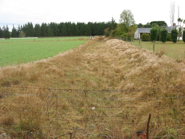
Photo 1: Flood diversion Channel
| 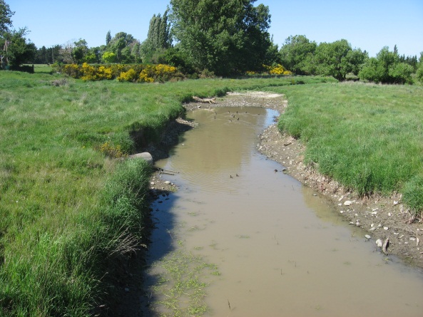
Photo 2: Branch of Hororata River
|
8.9 Rapid Flood Modelling
The Council has undertaken 'Rapid Flood Hazard Assessment' modelling for its main townships. The modelling uses DHI MIKE 21 to simulate rainfall on grid with the outputs processed through ArcGIS producing maps illustrating a range of flood deeps during different rainfall intensities and durations.
The rapid flood assessment has been generated to provide a high level summary of potential flood and ponding areas across the district during extreme rainfall events. The results from this study are not to be used to set floor levels. The results have not been ground tested and therefore are indicative only.
For a 50 year event, Figure 8‑5 shows the predicted flooding for Hororata.

Figure 8‑5 Rapid Flood Modelling, Hororata
8.10 Risk Assessment
A risk assessment has been undertaken for the Hororata scheme. The key output from the risk assessment is the identification of any extreme and high risks which need to be mitigated. In order to mitigate these risks they have been included and budgeted for in the projects within this LTP. Table 8‑3 details the risk priority rating and Table 8‑4 outlines the risks.
Table 8‑3 Risk Priority Rating
| > 50 | Extreme | Awareness of the event to be reported to Council. Urgent action to eliminate / mitigate / manage the risk. Document risk and action in the AMP. |
| 35-50 | Very High | Risk to be eliminated / mitigated / managed through normal business planning processes with responsibility assigned. |
| 14-35 | High | Manage risk using routine procedures. |
| 3.5-14 | Moderate | Monitor the risk. |
| < 3.5 | Low | Awareness of the event to be reported to Council. Immediate action required to eliminate / mitigate / manage the risk. Document risk and action in the AMP. |
Table 8‑4 Risks - Hororata
| Flooding from upper catchment | Develop master plan for stormwater | 2014 | 10 | 10 | 10 |
| Non-consented activities | Renewal of consents | 2014 | 27 | 27 | 6 |
| Stormwater management | remove river obstruction | 2017 | | 6 | 2.1 |
| Stormwater management | Master plan work | 2017 | | 6 | 2.1 |
The list of district wide risks can be found in 5Waters Activity Management Plan: Volume 1.
8.11 Asset Valuation Details
The total replacement value of assets within the Hororata Scheme is $312,095 as detailed in Table 8‑5 below.
Table 8‑5 Replacement Value, Hororata
Stormwater Reticulation
| Channel | $180,856
|
| Inlet-Outlet-Point | $4,482
|
| Manhole | $16,769
|
| Pipe | $105,008
|
| Valve | $4,980
|
8.12 Renewals
The renewal profile has been taken from the 2019 5 Waters Valuation.
Figure 8‑6 Hororata Stormwater Renewal Profile
8.13 Critical Assets
The criticality model for Hororata has been updated for the 2021 AcMP. The methodology of the criticality model can be found in 5Waters Activity Management Plan: Volume 1 and it provides details of how the criticality has been calculated for the reticulation assets. Table 8‑6 and Figure 8‑7 below show the calculated criticality for all of the assets within this scheme that have a recorded known length.
Table 8‑6 Length of Assets per Criticality Level
5
| Low | 4,511
|
4
| Medium-Low | 24
|
3
| Medium | 35
|
2
| Medium-High | 0 |
1
| High | 0 |
8.14 Asset Condition
The asset condition model was run for Hororata in 2021. The methodology of the model can be found in 5Waters Activity Management Plan: Volume 1 and it provides details of how the model has been calculated for the reticulation assets (particularly pipes). Figure 8‑8 below shows the level of asset condition for all of the assets within this scheme that have a recorded known condition.
Table 8‑7 provides a description of the condition rating used within the condition model.
Table 8‑7 Asset Condition Grading
1.0
| Excellent |
| 2.0 | Good |
| 3.0 | Moderate |
| 4.0 | Poor |
| 5.0+ | Fail |
8.15 Funding Program
There are no projects specific to the Hororata scheme in the 10 year LTP budgets, however the scheme will benefit from a number of district-wide initiatives. Expenditure and renewals have been reported on a district-wide basis in Volume 1.
An explanation of the categories within the budgets are as follows below:
-
Expenditure consists of operation and maintenance costs;
-
Renewals are replacement of assets which are nearing or exceeded their useful life;
-
Projects are investigations, decisions and planning activities which exclude capital works; and
-
Capital projects are activities involving physical works.
The list of district wide projects can be found in 5Waters Activity Management Plan: Volume 1.
Discussion on Projects
Projects have been determined based on their:
- Relevance to the scheme
- Requirement to be completed under legislation
- Ability to bring the scheme up to or maintain the Level of Service required under council's Asset Management Policy.
Many projects are jointly funded by more than one scheme and activity. Each scheme pays a pro-rata share only, equivalent to the number of connections.
Discussion on Capital and Projects
Where relevant, Capital (Levels of Service) and Capital (Growth) projects have been included in the scheme financial details.
Levels of Service Projects and growth splits have been provided to ensure the costs of population driven works are clear.
<<
5-Waters-Volume-4-Stormwater