The following key issues are associated with the West Melton water supply. A list of district wide issues are located in 5Waters Activity Management Plan: Volume 1.
Currently the Greater West Melton Water Supply Scheme is a high pressure restricted/unrestricted supply. Development of the water supply to the Greater West Melton community has been progressive over time to accommodate population growth and business development. The history of each individual part of the scheme is outlined below.
West Melton is currently experiencing moderate growth with a number of sub-divisions recently established and a number of new developments set to start within the next five years. To provide a high quality source of water, the Johnson Road and Edendale schemes were connected to the West Melton supply in 2020.
The original (Laird Place) scheme was formed in 1984 by the then Paparua County in conjunction with a subdivision constructed by a developer. The scheme was designed as a high pressure domestic supply with fire fighting capacity. However a suitable submersible pump was not installed until 2003, solving low pressure issues. The timber reservoir had a history of allowing contamination in via its timber roof. This problem was overcome by covering the reservoir with butanol in about 1988.
The scheme was substantially expanded in 2011 with the adoption of water supply infrastructure developed for the Gainsborough subdivision east of Weedons Ross Road. This included the Royston Common well, Rossington Drive tank farm and associated pumping system. Two additional bores constructed in conjunction with the Preston Downs development west of Weedons Ross Road were also incorporated. The Laird well was decommissioned at this time, as was the timber tank that had sustained damage in the September 2010 earthquake.
The West Melton township is now supplied by four groundwater bores; one near Royston Common in Halkett Grove, a second on Elizabeth drive in Preston Downs and a third on Jacqueline Drive, also in Preston Downs. The final bore is located in Wilfield and is connected to the Rossington reservoir site.
The Elizabeth Allen Drive and Jacqueline Drive bores have a history of providing low quality water after significant rainfall events. These wells were expected to provide a secure source of water, however the contamination following heavy rain meant that additional treatment was required.
When this problem was discovered in August 2012 the Elizabeth Allen Drive and Jacqueline Drive bores were taken offline. An Ultraviolet (UV) treatment system was installed in December 2012 to treat the Elizabeth Allen Drive bore to ensure water would remain safe for consumption. The Jacqueline Drive bore remained offline, as the surplus provided by the well was not needed at the time and required treatment before coming online.
The Elizabeth Allen Water Treatment plant was upgraded in September 2016 with filtration and a new UV unit. The upgrade provided treatment for both the Elizabeth Allen Drive and Jacqueline Drive bores.
The Royston Common bore failed in terms of water quality in 2014. A temporary UV unit was installed and the bore brought back online. In September 2016 the Rossington Drive water treatment plant was upgraded to provide filtration and a UV treatment for the Halkett Grove and Wilfield bore.
All water in West Melton is now UV treated and has turbidity control via 5 micron filtration.
In 2020 the West Melton reticulation was extended and connected to the Johnson Road and Edendale Water Supplies, creating the Greater West Melton Water Supply. The connection of these three schemes allowed for higher quality water to be provided to properties on Johnson Road and a more constant supply as the original scheme was operated as ‘timer on – pressure off’. The former Johnson Road bore, reservoirs, pump station and treatment shed have been removed from service.
Johnson Road Scheme
The Johnson Road scheme is located 2km south of West Melton Township and adjacent to Weedons Ross Road (see schematics). It provides UV treated groundwater to rural-residential properties in the Whitewood Crescent area.
The water supply was originally designed and installed (1986) as a high pressure unrestricted supply but changed to an individual tank supply system when Paparua Country Council took the scheme over. Water is supplied to the individual property owner's tanks (usually 9m3). Property owners are then responsible to pump from that tank for their own domestic/gardening uses.
The scheme operates as a 'timer on, pressure off' supply.
Poor water quality (presence of E Coli) resulted in installation of UV disinfection in 1995. This has not successfully addressed the bacteriological contamination issue.
In 2002 water meters were installed on all connections to reduce water consumption and a water charging regime implemented. The scheme was added to the district water rate in 2015/16 as part of the 2015-25 LTP consultation.
The Johnson bore was taken off-line 22 March 2020 and at that time was connected to the West Melton water supply.
Edendale Scheme
Edendale Rural Residential subdivision is located 4km west of West Melton, adjacent to State Highway 73 and Sandy Knolls Road and is a combination of rural residential lots (0.5-1.0 ha) and rural A blocks (4.0 ha). In total the Edendale water supply supplies water to 74 connections. The rural A blocks each have an additional 50mm irrigation connection. All connection are for residential properties and have backflow prevention in the scheme.
The scheme was designed in 1989 as a high pressure metered supply with full firefighting capacity. The 8 properties on the eastern side of Sandy Knolls Road were required to have a potable water supply installed as these properties were within the “plume of influence” from the septic tanks from the residential properties west of them.
Water for the Edendale water supply is obtained from a single deep well at Genesis Drive. The well is 300mm in diameter and 198m deep. The source is secure. This is the second well drilled at Edendale – the first one at West Coast Road was decommissioned in 2019.
A single bore pump delivers water to a 450m3 concrete reservoir. The pump is controlled by sensors located within the reservoir. The control system is linked to the Council’s Supervisory Control and Data Acquisition (SCADA) system and all inputs are powered by mains electricity.
Two main pumps linked to a variable speed drive and one jockey pump supply water from the reservoir to the reticulation.
There are 7 Rural blocks that have an additional 50mm irrigation connections.
The Council's policy for irrigation within the Edendale Supply area shall be:
a) Separate irrigation connections are available on lots 42 to 48 inclusive.
b) Supply shall be an extraordinary connection.
c) Maximum allowable usage rate of 5.0 litres per second.
d) Use of irrigation permitted only between the hours of 11 pm to 3 am.
e) Seven day roster produced by the Engineer shall be complied with.
On the 8 November 2017 Council decided to extend the Edendale water supply area and amalgamate it with adjoining water supplies; revoke clause 2 of policy W202; and incorporate the balance of policy W202 into the Water Supply Activity Management Plan.
In July 2020 the Edendale supply was connected to a new main along Finlays and Tricketts Roads and connected to the West Melton Scheme.
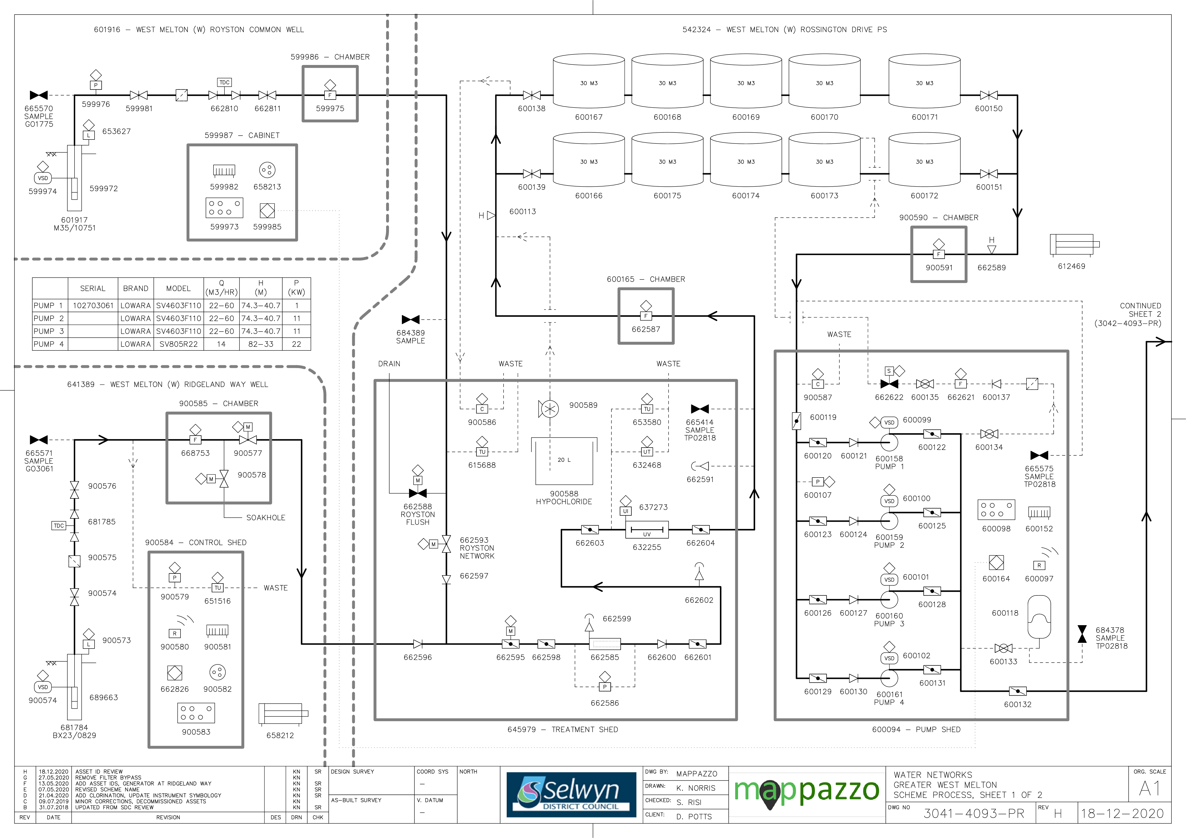
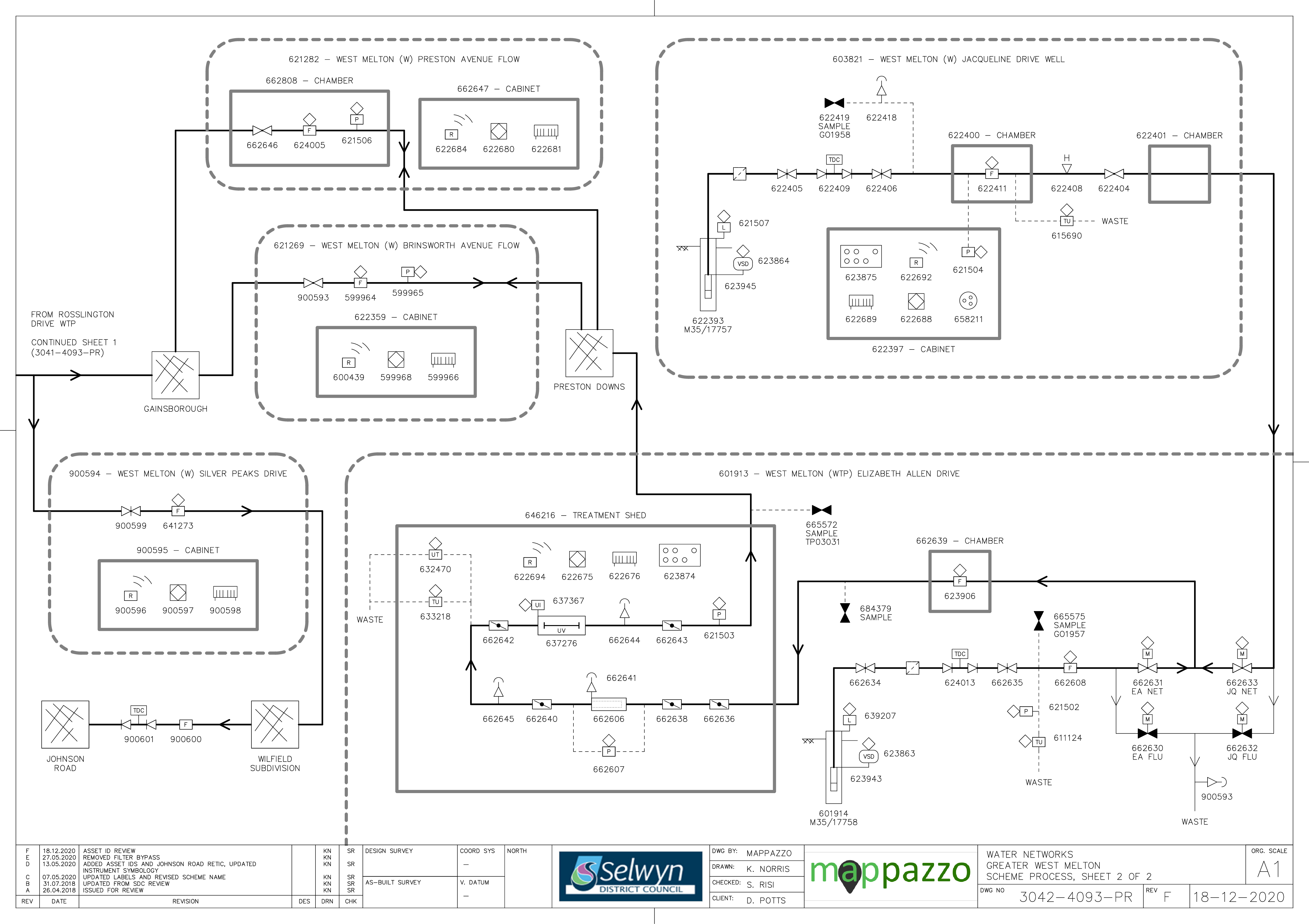
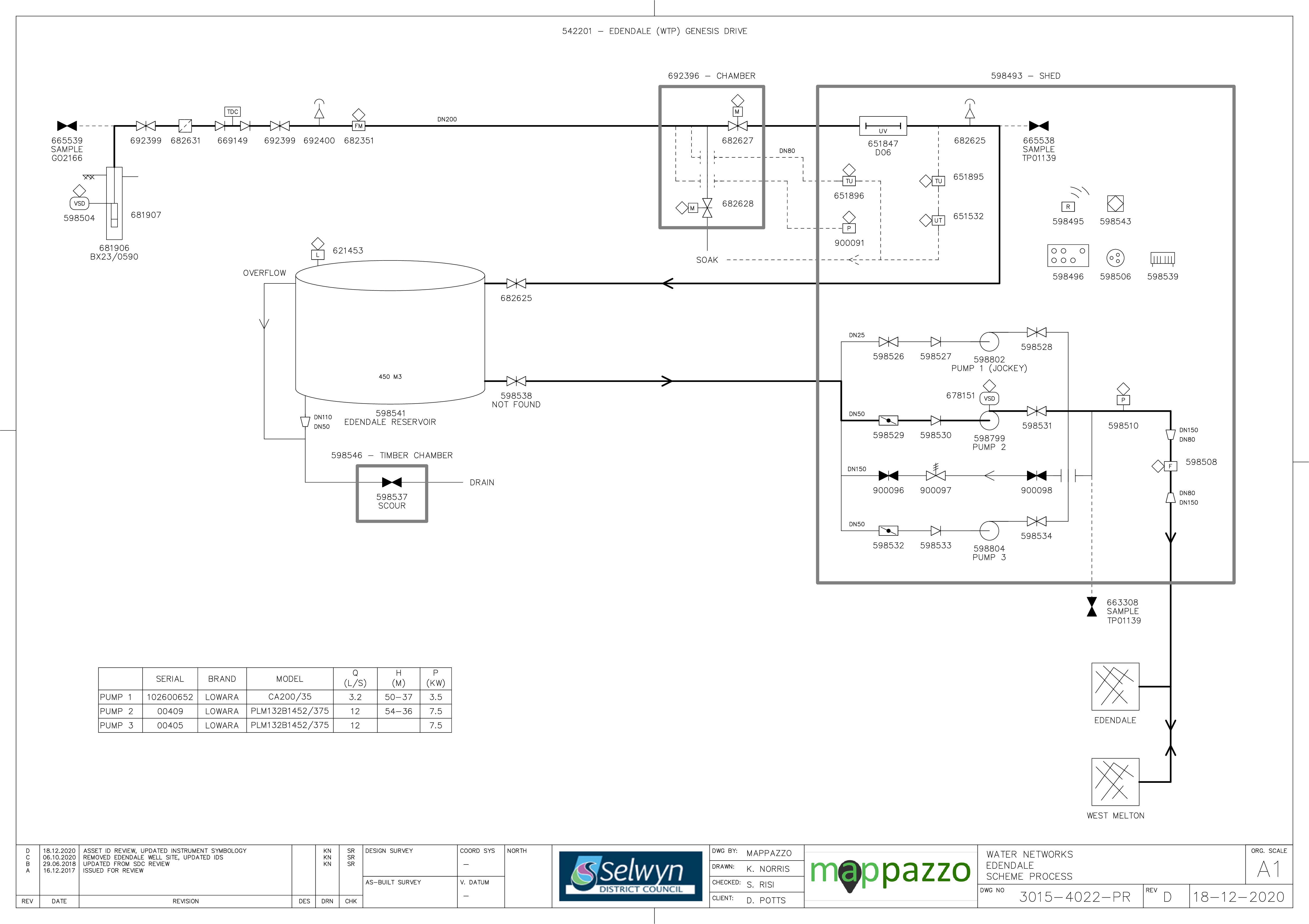
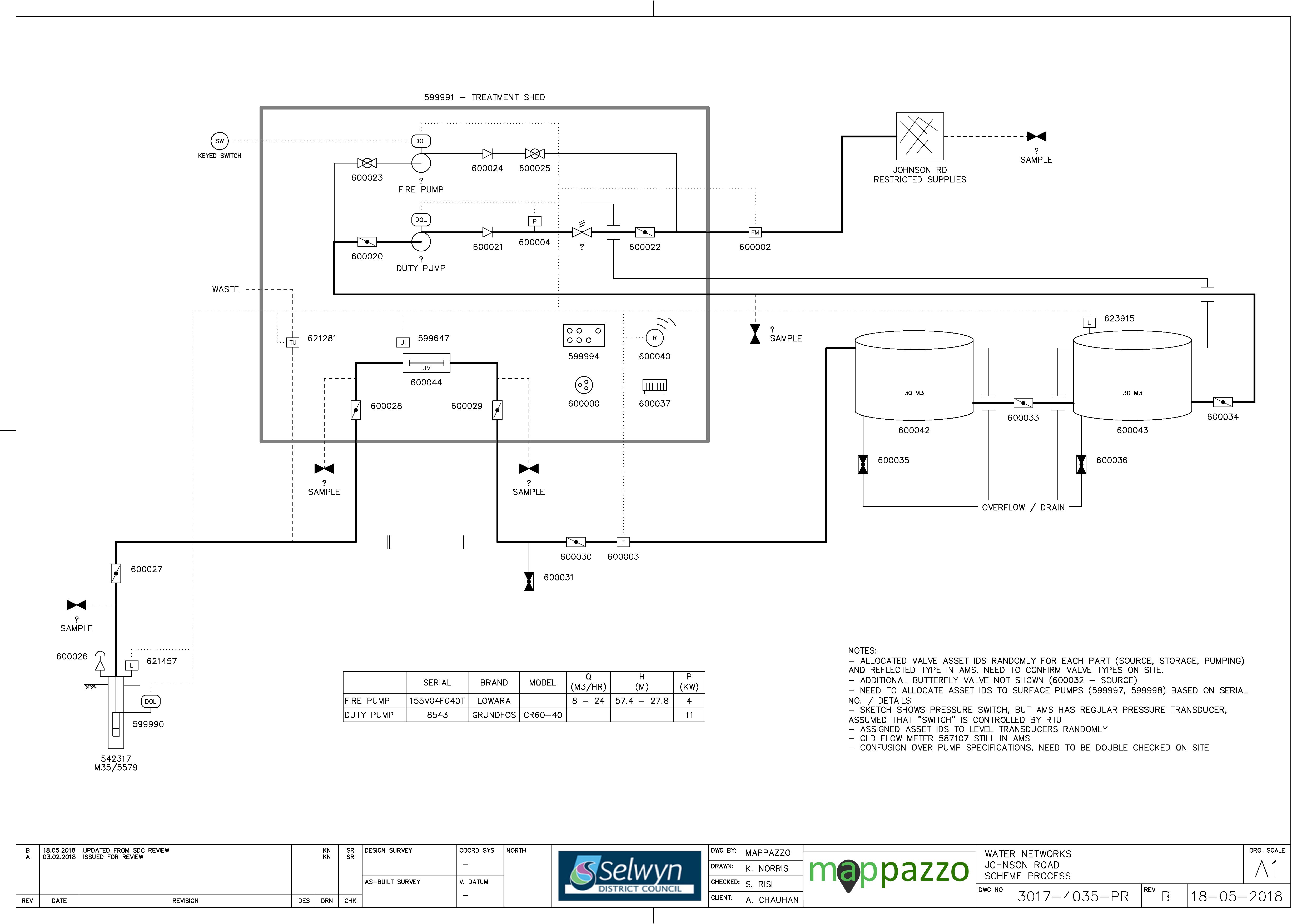
Figure 8‑2 Scheme Schematic
8.4 Scheme Capacity
Figure 8-3 shows the predicted increase in water demand (in accordance with the latest house projections) until 2051.
Hydraulic models have been used to plan future water infrastructure for West Melton, as part of a master planning exercise. The master planning provides an assessment of the sizing and timing of new infrastructure for new water sources (wells) and pipelines to service growth. Part of the master planning requires a water balance to be developed to forecast growth, using historical peak demand per household. The water balance forecasts the peak instantaneous flow per year versus the water resources available to determine the staging of new wells. The well staging assumes that one well is redundant for each water supply, to take into consideration maintenance of wells, planning/timing of new wells and security of supply i.e. to maintain average/peak demand.
The master planning exercise has identified that new wells are required immediately for West Melton (Table 8-3). An additional 7L/s is required in 2020/21 as well as the new Edendale bore and pipe upgrade. This demonstrates the importance of the reservoirs within the West Melton system, which buffer the well supply. 98L/s of additional well yield is required between 2021 and 2050. This is proposed through four additional wells, each with 30L/s capacity.
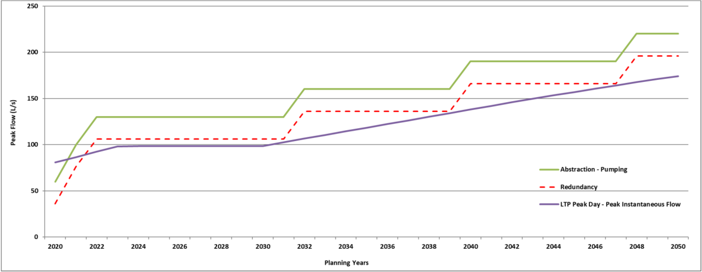
Figure 8‑3 West Melton Water Demand
Table 8‑2 Water Source Current Capacity
| Jacqueline Drive | 1 | 13 |
| Elizabeth Allen Drive | 1 | 10 |
| Rossington Drive | 1 | 13 |
| Ridgeland Way | 1
| 24
|
Edendale, Genesis Drive
| 1
| 12
|
Table 8‑3 Water Source Future Capacity
| West1 | Edendale - new bore
| 2020/21
| 7
|
| West2 | Edendale - upgraded pipe
| 2020/21
| 13
|
West3
| Edendale - new bore
| 2020/21
| 20
|
New well required
| TBC
| 2021/22
| 30
|
New well required
| TBC
| 2031/32
| 30
|
New well required
| TBC
| 2039/40
| 30
|
New well required
| TBC
| 2047/48
| 30
|
All capacity upgrades in West Melton to provide for growth are developer-led and funded. There is no water DC for West Melton.
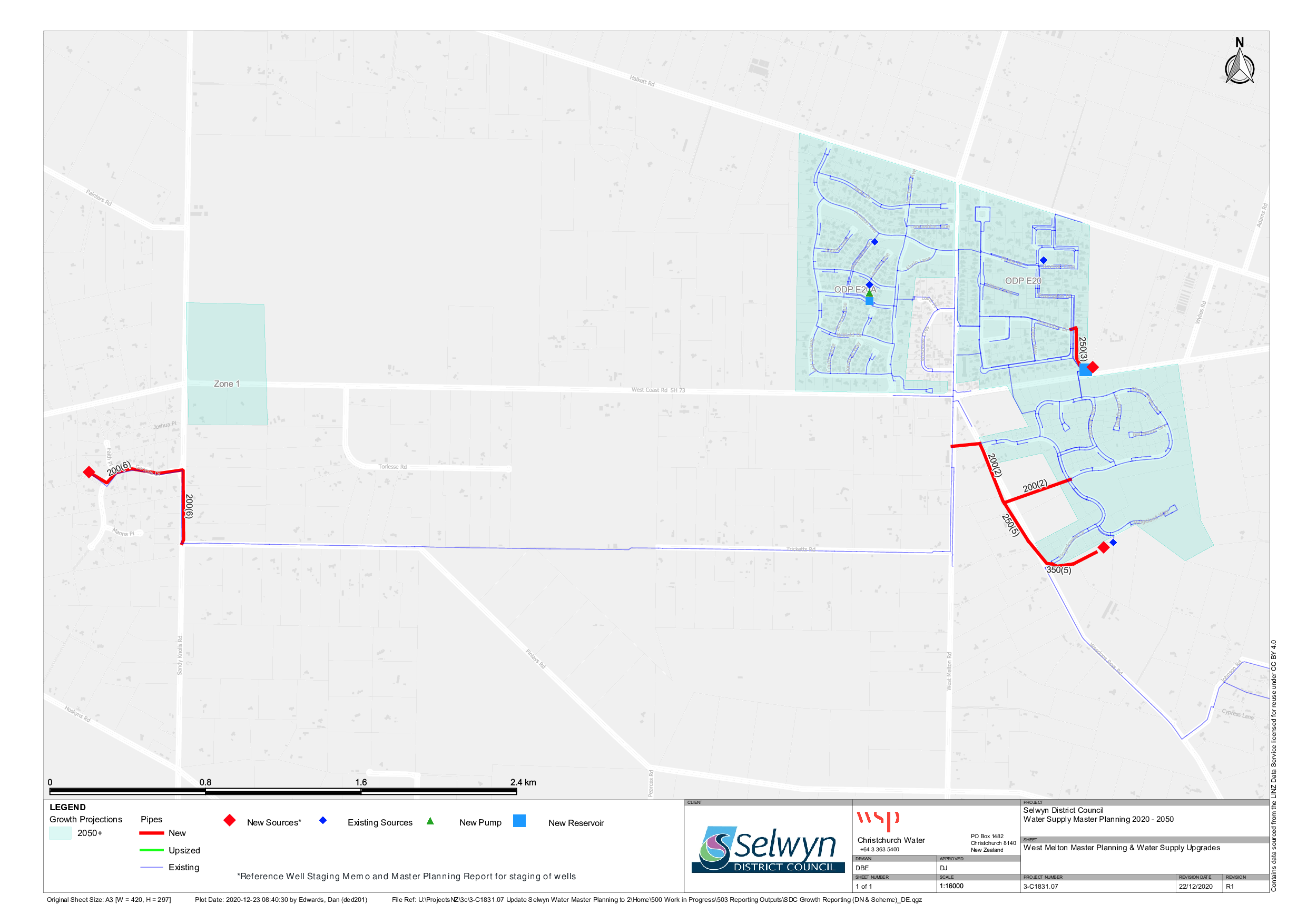
Figure 8‑4 Greater West Melton Master Plan
8.5 Resource Consents
The West Melton water supply has a number of resource consents. Table 8‑4 shows the water take permitted by the resource consents for this scheme.
Table 8‑4 Resource Consents
CRC164009
| To take and use groundwater
| Weedons Ross Road and Halkett Road, WEST MELTON | 18-Dec-15 | 13-Mar-47 | M35/17757
M35/17758
M35/10751
| 18
18
13.5
| 2,563 m3/day
(17,941 m3 per 7 days) Combined volume with CRC169800 not exceeding 567,576 m3 between 1 July and the following 30 June |
CRC121242
| To take and use water
| Weedons Ross Road and Halkett Road, WEST MELTON | 14-Mar-12 | 13-Mar-47 | M35/17757
M35/17758
M35/10751
| 18
18
13.5
| 2,563 m3/day
Restrictions on water take depending on standing water levels in bores
|
CRC169800
| To take and use groundwater
| Johnson Road, West Melton
| 14-Jun-18
| 14-Jun-38
| M35/5579
| 15
| 9,072 m3 per 7 days
194,400 m3 between 1 July - 30 June
|
CRC172478
| To take and use groundwater
| Genesis Drive, West Melton
| 16-Dec-16
| 16-Feb-40
| M35/3673
BX23/0590 | 19
65
| 7,616 m3 per 7 days
13,910 m3 per 7 days
Combined volume not exceeding 13,910 m3 per 7 days
and 163,200 m3 between 1 July - 30 June
|
CRC192996
| To take and use groundwater
| cnr Westcoast Road (SH73) and Weedons Ross Road, West Melton | 10-Jul-19
| 26-Feb-26
| M35/6201
BX23/0829
| 26
70
| 15,071 m3 per 7 days
|
8.6 Water Quality
The West Melton water supply consists of four non-secure wells and one well (Edendale) which is currently deemed secure. The wells are sampled twice weekly and the reticulation is sampled weekly.
The following details E. coli transgressions for the period 2012 to 2020.
Source
There have been 64 incidences of E. coli being identified in source water during this period.
Figure 8‑5 E.coli transgressions - Source
Treatment
There have been 14 E. coli treatment transgressions during this period.
Figure 8‑6 E. coli transgressions - Treatment
Zone
There have been 14 E. coli transgressions during this period.
Figure 8‑7 E. coli transgressions - Zone
Chemical Analysis
The following is a summary of the raw water chemical analysis carried out at the West Melton Water Supply.
Table 8‑5 Raw Water Chemical Analysis Summary: Edendale Bore
Total Lead (g/m3)
| 0.01 (Maximum
Acceptable
Value)
| 0.00022
| 0.00038
| 0.00027
| <0.00011
| 0.000142
| <0.00011
| <0.00011
| <0.00011
| ✓
|
pH (pH units)
| 7 - 8.5 (Guideline Value)
| 7.5
| 7.3
| 7.1
| 7.6
| 7.6
| 7.7
| 7.7
| 7.9
| ✓
|
Total Hardness (g/m3 as CaCO3)
| <200 (Guideline Value)
| 60
| 66
| 67
| 67
| 68.4
| 56.8
| 57.8
| 57.9
| ✓
|
Total Calcium (g/m3)
| None
| 18
| 19
| 19.7
| 19.6
| 20.08
| 19.45
| 19.73
| 19.68
| ✓
|
Total Iron (g/m3)
| <0.2 (Guideline Value)
| <0.02
| <0.021
| <0.021
| <0.021
| 0.023
| <0.021
| <0.021
| <0.021
| ✓
|
Total Sodium (g/m3)
| <200 (Guideline Value)
| 11
| 11.6
| 12.2
| 13
| 12.22
| 9.44
| 10.15
| 9.57
| ✓
|
Nitrate - Nitrogen (g/m3)
| 11.3 (Maximum Acceptable Value)
| 7.2
| 6.1
| 6.6
| 6.4
| 6.69
| 4.36
| 5.69
| 5.65
| ✓
|
Table 8‑6 Raw Water Chemical Analysis Summary: Royston Common Bore
Total Lead (g/m3)
| 0.01 (Maximum
Acceptable
Value)
| 0.00041
| 0.00049
| 0.00014
| <0.00011
| <0.00011
| 0.00396
| ✓
|
pH (pH units)
| 7 - 8.5 (Guideline Value)
| 7.1
| 7.2
| 7.6
| 7.4
| 7.5
| 7.6
| ✓
|
Total Hardness (g/m3 as CaCO3)
| <200 (Guideline Value)
| 56
| 52
| 54
| 45.8
| 64.3
| 55.8
| ✓
|
Total Calcium (g/m3)
| None
| 18.4
| 17.2
| 17.9
| 15.02
| 21.05
| 18.11
| ✓
|
Total Iron (g/m3)
| <0.2 (Guideline Value)
| <0.021
| <0.021
| <0.021
| <0.021
| <0.021
| 0.036
| ✓
|
Total Sodium (g/m3)
| <200 (Guideline Value)
| 6.3
| 6
| 6.3
| 5.06
| 7.01
| 6.47
| ✓
|
Nitrate - Nitrogen (g/m3)
| 11.3 (Maximum Acceptable Value)
| 3.3
| 2.5
| 2.4
| 1.55
| 3.02
| 2.48
| ✓
|
Table 8-7 Raw Water Chemical Analysis Summary: Ridgeland Way Bore
Total Lead (g/m3)
| 0.01 (Maximum Acceptable Value)
| -
| <0.00011
| ✓
|
pH (pH units)
| 7 - 8.5 (Guideline Value)
| 7.7
| 7.6
| ✓
|
Total Hardness (g/m3 as CaCO3)
| <200 (Guideline Value)
| 44.1
| 43
| ✓
|
Total Calcium (g/m3)
| None
| 15.05
| 14.4
| ✓
|
Total Iron (g/m3)
| <0.2 (Guideline Value)
| 0.064
| <0.021
| ✓
|
Total Sodium (g/m3)
| <200 (Guideline Value)
| 5.56
| 5.8
| ✓
|
Nitrate - Nitrogen (g/m3)
| 11.3 (Maximum Acceptable Value)
| 1.87
| 2
| ✓
|
Table 8-8 Raw Water Chemical Analysis Summary: Jacqueline Drive Bore
Total Lead (g/m3)
| 0.01 (Maximum
Acceptable Value)
| 0.00036
| <0.00011
| 0.0002
| 0.000116
| <0.00011
| ✓
|
pH (pH units)
| 7 - 8.5 (Guideline Value)
| 7.2
| 7.7
| 7.4
| 7.6
| 7.7
| ✓
|
Total Hardness (g/m3 as CaCO3)
| <200 (Guideline Value)
| 47
| 49
| 45.6
| 53.9
| 49.9
| ✓
|
Total Calcium (g/m3)
| None
| 15.7
| 16.3
| 15.28
| 18.06
| 16.63
| ✓
|
Total Iron (g/m3)
| <0.2 (Guideline Value)
| 0.21
| <0.021
| <0.021
| <0.021
| <0.021
| X
|
Total Sodium (g/m3)
| <200 (Guideline Value)
| 5.8
| 5.8
| 4.9
| 6.01
| 5.76
| ✓
|
Nitrate - Nitrogen (g/m3)
| 11.3 (Maximum Acceptable Value)
| 2.3
| 2.1
| 1.57
| 2.38
| 2.11
| ✓
|
Table 8-9 Raw Water Chemical Analysis Summary: Elizabeth Allen Drive Bore
Total Lead (g/m3)
| 0.01 (Maximum Acceptable Value)
| 0.00036
| <0.00011
| <0.00011
| 0.000336
| <0.00011
| ✓
|
pH (pH units)
| 7 - 8.5 (Guideline Value)
| 7.2
| 7.7
| 7.5
| 7.5
| 7.6
| ✓
|
Total Hardness (g/m3 as CaCO3)
| <200 (Guideline Value)
| 47
| 49
| 45.4
| 54.2
| 52.2
| ✓
|
Total Calcium (g/m3)
| None
| 15.7
| 16.3
| 15.25
| 17.33
| 17.29
| ✓
|
Total Iron (g/m3)
| <0.2 (Guideline Value)
| 0.21
| <0.021
| <0.021
| 0.75
| <0.021
| X
|
Total Sodium (g/m3)
| <200 (Guideline Value)
| 5.8
| 5.8
| 5.07
| 6.68
| 5.94
| ✓
|
Nitrate - Nitrogen (g/m3)
| 11.3 (Maximum Acceptable Value)
| 2.3
| 2.1
| 1.56
| 2.67
| 2.22
| ✓
|
8.7 Scheme Assets
A summary of material and diameter for pipes in West Melton is shown below in Figure 8‑8 and Figure 8‑9.
Figure 8‑8 Pipe Material – West Melton
Figure 8‑9 Pipe Diameter – West Melton
8.8 Operational Management
The water supply is operated and maintained under two maintenance contracts as follows:
- Contract 1241: Water Services Contract. Contract is with SICON who undertakes investigations, conditions inspections, proactive and reactive maintenance and minor asset renewals; and
- Contract 1202: Parks and Reserves Contract. Contract is with SICON who undertakes the maintenance of land scape features related to water services e.g. mowing, gardens etc.
Water quality sampling is completed under an agreement with Food and Health Ltd as required.
8.9 Photos of Main Assets
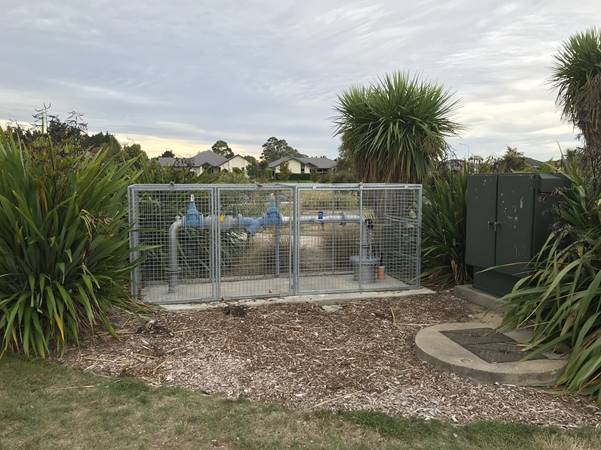
Photo 1: Royston Common Well Location
| 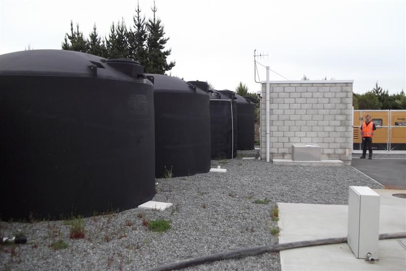
Photo 2: Rossington Drive Tanks and Pump Building
|
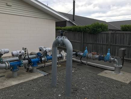
Photo 3: Elizabeth Allen Drive Wellhead
|
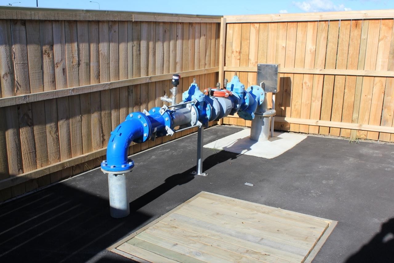
Photo 4: Jacqueline Drive Wellhead
|
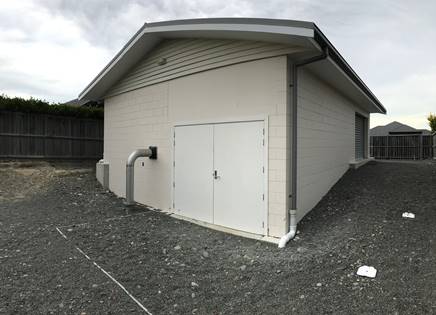
Photo 5: Elizabeth Allen Treatment Plant
| 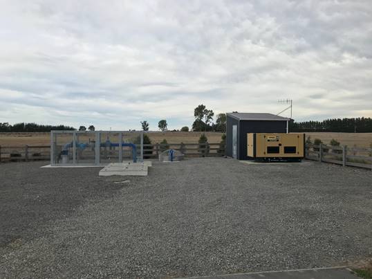
Photo 6: Willfield Bore
|
8.10 Risk Assessment
A risk assessment has been undertaken for the West Melton scheme. The key output from the risk assessment is the identification of any extreme and high risks which need to be mitigated. In order to mitigate these risks they have been included and budgeted for in the projects within this LTP. Table 8-10 details the risk priority matrix and Table 8-11 outlines the risks for this scheme.
Table 8-10 Risk Priority Rating
| > 50 | Extreme | Awareness of the event to be reported to Council. Urgent action to eliminate / mitigate / manage the risk. Document risk and action in the AMP. |
| 35-50 | Very High | Risk to be eliminated / mitigated / managed through normal business planning processes with responsibility assigned. |
| 14-35 | High | Manage risk using routine procedures. |
| 3.5-14 | Moderate | Monitor the risk. |
| < 3.5 | Low | Awareness of the event to be reported to Council. Immediate action required to eliminate / mitigate / manage the risk. Document risk and action in the AMP. |
Table 8-11 Risks – West Melton
| Catchment contamination impacts bores | Investigate source of contamination | 2014 | 20 | 7 | 7 |
| Electrical failure due to lightning or network spikes | Install surge diverters | 2014 | 10 | 3.5 | 3.5 |
| Failure to meet NES water meter standards | NES Water Meter Compliance | 2014 | 20 | 6 | 6 |
| Inability to collect income from non-metered properties | Install property water meters | 2014 | 27 | 0.6 | 0.6 |
| Non-compliance with the DWSNZ | DWSNZ - Age Testing | 2014 | 10 | 0.7 | 0.7 |
| Non-compliance with the DWSNZ | DWSNZ - Bore-head security | 2014 | 10 | 10 | 10 |
The list of district wide risks can be found in 5Waters Activity Management Plan: Volume 1.
8.11 Asset Valuation Details
The total replacement value of assets within the West Melton water scheme is $12,552,454 with further details in Table 8-12 below.
Table 8-12 Replacement Value, West Melton
Plant and Equipment
| $3,053,782
|
Water Reticulation
| Hydrant | $423,395
|
| Lateral | $207,224
|
| Pipe | $7,665,194
|
| Supply Point | $792,136
|
| Valve | $410,722
|
8.12 Renewals
The renewal profile has been taken from the 2019 5 Waters Valuation. A graph showing the renewals for this scheme are shown by Figure 8‑10 below. There is a backlog of assets due for renewal immediately. A smaller peak in renewals will also occur in 2027/28.
Figure 8‑10 West Melton Water Renewal Profile
8.13 Critical Assets
The criticality model for West Melton has been updated for the 2021 AcMP. The methodology of the criticality model can be found in 5Waters Activity Management Plan: Volume 1 and it provides details of how the criticality has been calculated for the reticulation assets. Table 8-13 and Figure 8‑11 below shows the calculated criticality for all of the assets within this scheme that have a recorded known length.
Table 8-13 Length of Assets per Criticality Level
5
| Low | 26,271
|
4
| Medium-Low | 9,679
|
3
| Medium | 13,976
|
2
| Medium-High | 8,373
|
1
| High | 0
|
8.14 Asset Condition
The asset condition model was run for West Melton in 2021. The methodology of the model can be found in 5Waters Activity Management Plan: Volume 1 which provides details of how the model has been calculated for the pipe reticulation assets. Figure 8‑12 below shows the level of asset condition for these assets within this scheme that have a recorded known condition.
Table 8‑14 provides a description of the condition rating used within the condition model.
Table 8-14 Asset Condition Grading
| 1.0 | Excellent |
| 2.0 | Good |
| 3.0 | Moderate |
| 4.0 | Poor |
| 5.0+ | Fail |
The number of pipe faults is also measured through the asset management system. Figure 8‑13 shows the known historic pipe failures within this scheme.
8.15 Funding Program
The 10 year budgets for West Melton are shown by Table 8‑15. Budgets are split into expenditure, renewals, projects and capital projects. Expenditure and renewals have been reported on a district-wide basis in Volume 1. All figures are ($) not adjusted for CPI “inflation". They are calculated on historical data, and population growth where relevant.
Table 8-15 West Melton Budget Summary
| 2021/2022 | $26,000
| $328,000
|
| 2022/2023 | $5,000
| $1,250,000
|
| 2023/2024 | -
| $1,507,845
|
| 2024/2025 | -
| $100,000
|
| 2025/2026 | -
| -
|
| 2026/2027 | -
| -
|
2027/2028
| -
| -
|
2028/2029
| -
| -
|
2029/2030
| -
| -
|
2030/2031
| -
| -
|
| Total | $31,000
| $3,185,845
|
An explanation of the categories within the budgets are as follows below:
-
Expenditure consists of operation and maintenance costs;
-
Renewals are replacement of assets which are nearing or exceeded their useful life;
-
Projects are investigations, decisions and planning activities which exclude capital works; and
-
Capital projects are activities involving physical works.
There are a number of projects for West Melton water scheme in the LTP budget (Table 8-16).
Table 8-16 Key Projects for West Melton water scheme
Capital Projects
| 409390038
| West Melton Growth
| $172,000
| $800,000
| $307,845
| -
| 50% G
50% LoS
|
Capital Projects
| TBC
| Elizabeth Allen treated water storage and pump station
| $100,000
| $400,000
| -
| -
| 100% LoS
|
Capital Projects
| TBC
| Installation of restrictor housings onto all Johnson Road water connections to control flow entering that portion of the Greater West Melton network
| -
| $50,000
| -
| -
| 100% LoS
|
Capital Projects
| TBC
| Additional pressure sensors to be added into the network, investigated optimal network location and provide additional sensors Additional 3 No. monitoring site (pressure/flow/allowance future chlorine if require)
| $10,000
| -
| -
| -
| 100% LoS
|
Capital Projects
| TBC
| Rossington Drive - move wetwell location away from WTP and reservoir storage or isolate
| -
| -
| $1,000,000
| -
| 100% LoS
|
Capital Projects
| TBC
| Addition of permanent infrastructure (i.e. injection point) to allow for instantaneous automatic chorine dosing at the WTP, if and when required
| $20,000
| -
| -
| -
| 100% LoS
|
Capital Projects
| TBC
| 100mm dead end connection to connect, across from Community Centre
| -
| -
| -
| $100,000
| 100% LoS
|
Capital Projects
| TBC
| Edendale filtration
| -
| -
| $200,000
| -
| 100% LoS
|
Projects
| TBC
| Various investigations: Rossington Drive risk assessment; hydraulic modelling of overall scheme and tank farm to identify storage requirements and turnover management; bore security
| $26,000
| $5,000
| -
| -
| 100% LoS
|
* LoS refers to Level of Service; G refers to Growth
The list of district wide projects can be found in 5Waters Activity Management Plan: Volume 1.
<<
5-Waters Volume 2 - Water Supplies