<<
5-Waters-Volume-5-Land-Drainage
2 Ellesmere Land (No. 3) Drainage District
2.1 Scheme Summary
Scheme Area
| 1,265.59 ha |
Scheme Coverage - Total Capital value (as at 1 July 2020)
| Poor drainage
| $110,531,000
|
Imperfectly drained
| $59,386,000 |
Moderately well drained
| $7,420,000
|
Well drained
| $45,551,000 |
Annual charge
| 161
|
Systems components
| Drain Length (m) | 25,905
|
| Pump stations (No.) | None
|
| Other assets | None |
| History | Installation Date | Installed progressively from 1850's |
Value ($)
| Replacement Cost | $3,338,222
|
| Depreciated Replacement Cost | $3,338,222
|
Financial
| Annual maintenance cost
% of total Land Drainage maintenance
| $10,000/year on average
5% of total Land Drainage maintenance spend
|
| Drainage Outlet | Ultimate discharge point | Te Waihora (Lake Ellesmere) |
| Sustainability | Sustainable drain management practices | Adopted and Encouraged |
2.2 Key Issues
There are no key issues are associated with the Ellesmere Drainage District. A list of district wide issues are located in 5Waters Activity Management Plan: Volume 1.
2.3 Overview & History
The Ellesmere scheme has a rating area of 1,266ha, servicing a total area of 2,820ha between Curries Road and Bethels roads with drainage outlets for this scheme via the Selwyn River in the vicinity of Coes Ford. The ultimate receiving environment for this area is Te Waihora (Lake Ellesmere).
Miles drain located on the eastern extreme of the Ellesmere scheme was an addition to the original scheme. The drainage system includes a number of privately owned flood flap valves.
The land drainage scheme was constructed to remove groundwater, allowing farming to occur. As a secondary use, stormwater from properties is also discharged to the network of open drains.
In 2011, a variation to the Te Waihora Water Conservation Order was made, bringing a strong cultural focus into place. The Selwyn - Waihora Zone Committee (established under the Canterbury Water Management Strategy) also released its Zone Implementation Plan (ZIP) and ZIP addendum.
2.4 Resource Consents
There are no existing consents for this land drainage scheme.
Land drainage activities are controlled through Rules 5.57 and 5.58 under the Land and Water Plan. An application was lodged in November 2011, with a request that it be put on hold pending discussion with stakeholders.
2.5 Scheme Assets
This scheme is predominately Land drainage channels which are excavated open channels that intercept, convey and discharge groundwater to allow productive use of land.
2.6 Operational Management
Council delegates some aspects of management of the Land Drainage network to 9 Land Drainage Committee's comprising of local residents with an interest in the Land Drainage network. Council Service Delivery Staff work alongside the Committee's to prioritise and facilitate maintenance activities which are undertaken by a number of local contractors.
2.7 Photos of Main Assets
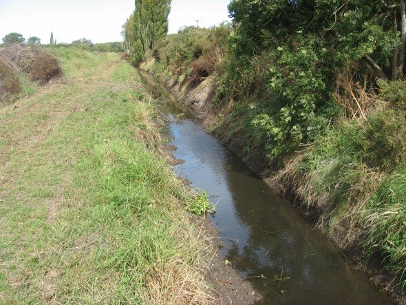
Photo 1: Miles Drain – flood bank left hand bank
| 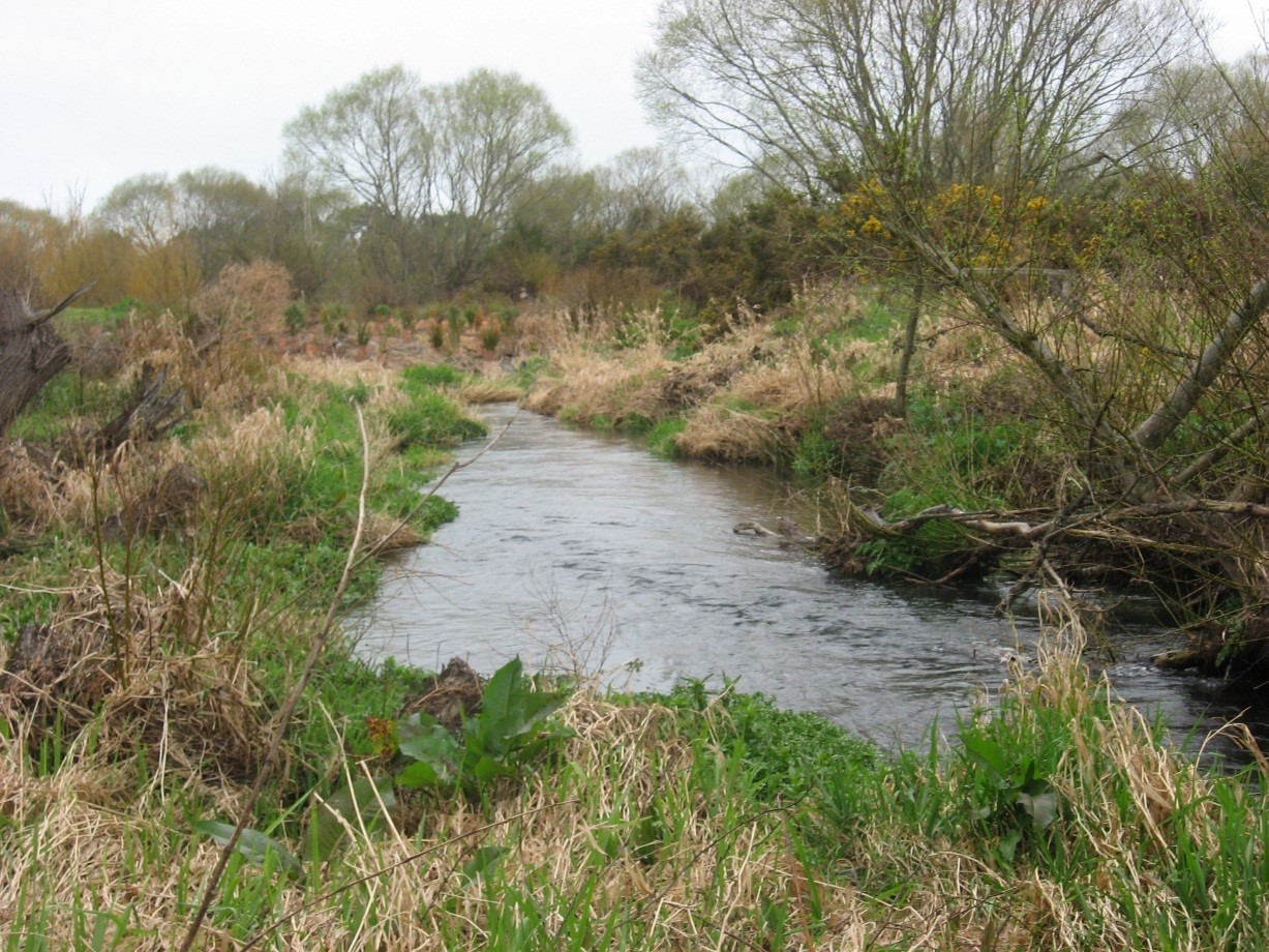
Photo 2: Discharge from Silverstream Drain
|
2.8 Risk Assessment
A risk assessment has been undertaken for the Ellesmere scheme. The key output from the risk assessment is the identification of any extreme and high risks which need to be mitigated. In order to mitigate these risks they have been included and budgeted for in the projects within this LTP. Table 2‑1 details the risk priority rating, Table 2‑2 outlines the risk identified in this scheme and Table 2‑7 details the key projects.
Table 2‑1 Risk Priority Rating
| > 50 | Extreme | Awareness of the event to be reported to Council. Urgent action to eliminate / mitigate / manage the risk. Document risk and action in the AMP. |
| 35-50 | Very High | Risk to be eliminated / mitigated / managed through normal business planning processes with responsibility assigned. |
| 14-35 | High | Manage risk using routine procedures. |
| 3.5-14 | Moderate | Monitor the risk. |
| < 3.5 | Low | Awareness of the event to be reported to Council. Immediate action required to eliminate / mitigate / manage the risk. Document risk and action in the AMP. |
Table 2‑2 Risks – Ellesmere
| Inadequate drainage at Raven Drive | Raven Drive drainage upgrade | 2017 | | 9 | 2 |
The list of district wide risks can be found in 5Waters Activity Management Plan: Volume 1.
2.9 Asset Valuation Details
The total replacement value of assets within the Ellesmere Scheme is $3,338,222 with further details in Table 2‑3 below. All of the value is made up of channels.
Table 2‑3 Replacement Value, Ellesmere
|
Land Drainage | Channel | $3,338,222 |
Channels are broken down into drains, pipes and stock banks. The Ellesmere Land drainage district is made up of classified drains.
2.10 Renewals
The renewal profile has been taken from the 2019 5Waters Valuation. There are no renewals for this scheme. This asset has a maintained infinite life.
2.11 Critical Assets
The criticality model for Ellesmere has been updated for the 2021 AcMP. The methodology of the criticality model can be found in 5Waters Activity Management Plan: Volume 1 and it provides details of how the criticality has been calculated for the reticulation assets. Table 2‑4 and Figure 2‑2 below show the calculated criticality for all of the assets within this scheme that have a recorded known length.
Table 2‑4 Length of Assets per Criticality Level
5
| Low | 14,190 |
4
| Medium-Low | 3,105
|
3
| Medium | 8,636 |
2
| Medium-High | 0 |
1
| High | 0 |
2.12 Asset Condition
The asset condition model was run for Ellesmere in 2021. The methodology of the model can be found in 5Waters Activity Management Plan: Volume 1 and it provides details of how the model has been calculated for the reticulation assets (particularly pipes). There is no known recorded condition for assets within this scheme.
2.13 Funding Program
There are no projects specific to the Ellesmere scheme in the 10 year LTP budgets, however the scheme will benefit from a number of district-wide initiatives. The list of district wide projects can be found in 5Waters Activity Management Plan: Volume 1.
<<
5-Waters-Volume-5-Land-Drainage