<<
5-Waters-Volume-5-Land-Drainage
1 Arthurs Pass Drainage Scheme
1.1 Scheme Summary
Scheme Area
| 15.44 ha |
Scheme Coverage - Rated properties (2020/21)
| Class A
| Currently not rated
|
Systems components
| Drain Length (m) | None |
| Pump stations (No.) | None |
| Other assets | Floodbank |
| History | Installation Date | Installed progressively from 1850's |
Value ($)
| Replacement Cost (2020)
| $64,675
|
Depreciated Replacement Cost (2020)
| $64,675
|
| Financial | Annual maintenance cost
% of total Land Drainage maintenance
| $3,000/year on average
2% of total Land Drainage maintenance spend
|
| Drainage Outlet | Ultimate discharge point | Bealey River |
| Sustainability | Sustainable drain management practices | Adopted and Encouraged |
1.2 Key Issues
The following key issues are associated with the Bealey Flood Protection area. A list of district wide issues are located in 5Waters Activity Management Plan: Volume 1.
Table
1‑1 Bealey Flood Protection Area Key Issues
| Risk to the Arthurs Pass Village following breach of Bealey River Stop Bank. | Regular inspections of the stop bank and maintaining close working relationship with Arthurs Pass Community Committee. |
1.3 Overview & History
The Arthur's Pass drainage district relates to the flood protection works within the Bealey River. The flood protection scheme consists of a manmade floodbank constructed from local sourced rock positioned along critical points of the Bealey River. These form a barrier and divert extreme river flood events away from the Arthurs Pass township. The total length of flood protection works is 300m.
In February 2009 armouring work was undertaken based on an assessment by Mr B Reid (ex Environment Canterbury Catchment Engineer) and in consultation with the Department of Conservation. No consents were required to undertake this work.
Work is only undertaken after severe flooding, last required in 2012/13. Annual maintenance is not required, but inspections should be undertaken at regular intervals.
1.4 Resource Consents
There are no existing consents for this land drainage scheme. Works are completed as a permitted activity under Waimak River Regional Plan.
1.5 Scheme Assets
The stopbank/flood bank is constructed from locally sourced river rock from the Bealey River. Larger boulders are used as armering.
There are no other assets within this scheme.
1.6 Operational Management
Council delegates some aspects of management of the Land Drainage network to 9 Land Drainage Committee's comprising of local residents with an interest in the Land Drainage network. Council Service Delivery Staff work alongside the Committee's to prioritise and facilitate maintenance activities which are undertaken by a number of local contractors.
1.7 Photos of Main Assets
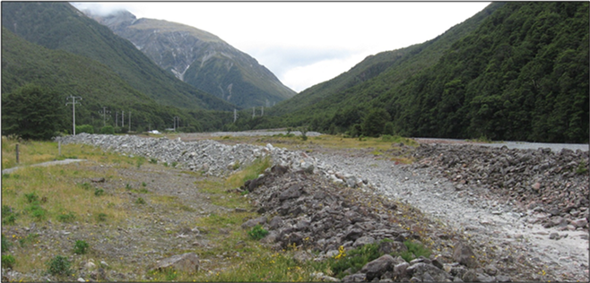
Figure
1‑2 Flood Protection Works
1.8 Risk Assessment
A risk assessment has been undertaken for the Arthurs Pass scheme. The key output from the risk assessment is the identification of any extreme and high risks which need to be mitigated. In order to mitigate these risks they have been included and budgeted for in the projects within this LTP. Table 1‑2 details the risk priority rating, Table 1‑3 outlines the risks and the list of key projects is found in Table 1‑6.
Table
1‑2 Risk Priority Rating
| > 50 | Extreme | Awareness of the event to be reported to Council. Urgent action to eliminate / mitigate / manage the risk. Document risk and action in the AMP. |
| 35-50 | Very High | Risk to be eliminated / mitigated / managed through normal business planning processes with responsibility assigned. |
| 14-35 | High | Manage risk using routine procedures. |
| 3.5-14 | Moderate | Monitor the risk. |
| < 3.5 | Low | Awareness of the event to be reported to Council. Immediate action required to eliminate / mitigate / manage the risk. Document risk and action in the AMP. |
Table
1‑3 Risks – Arthurs Pass
| Flood bank failure would impact on local properties without Council's knowledge | Review options to better monitor stockbank condition and performance | 2014 | 6 | 6 | 6 |
The list of district wide risks can be found in 5Waters Activity Management Plan: Volume 1.
1.9 Asset Valuation Details
The total replacement value of assets within the Arthurs Pass Scheme is $64,675 with further details in Table 1‑4 below. All of the value is made up of the stopbank.
Table
1‑4 Replacement Value, Arthurs Pass
|
Land Drainage | Channel
| $64,675
|
Channels are broken down into the following subcategories: drains, pipes and stopbanks. At Arthurs Pass there is a primary and secondary stopbank which protects the township from flooding.
1.10 Renewals
The renewal profile has been taken from the 2019 5 Waters Valuation. There are no renewals for this scheme. This asset has an infinite life.
1.11 Critical Assets
The criticality model for has been updated for the 2021 AcMP. The methodology of the criticality model can be found in 5Waters Activity Management Plan: Volume 1 and it provides details of how the criticality has been calculated for the reticulation assets. There is no criticality assessment for this scheme.
1.12 Asset Condition
The asset condition model was run for Arthurs Pass in 2021. The methodology of the model can be found in 5Waters Activity Management Plan: Volume 1 and it provides details of how the model has been calculated for the reticulation assets (particularly pipes). The condition of this asset is maintained at a high level.
1.13 Funding Program
There are no projects specific to the Arthurs Pass scheme in the 10 year LTP budgets, however the scheme will benefit from a number of district-wide initiatives. The list of district wide projects can be found in 5Waters Activity Management Plan: Volume 1.
<<
5-Waters-Volume-5-Land-Drainage