<<
5-Waters Volume 2 - Water Supplies
6 Darfield Water Supply
6.1 Scheme Summary
| Estimated Population Served | 3,846
|
Scheme Coverage (1 Jan 2021)
| Full Charges | 1,026
| Includes 260 restricted connections
Rural A 173 connections (629 Units)
Rural B 87 connections (211 Units)
|
Half Charges
| 0
|
| >1 Charges | 302
|
System Components
|
Bores/Intakes (No.) |
2
|
|
Treatment/Disinfection | UV treatment installation underway
Chlorination to follow |
|
Reservoirs (No.) |
2
|
|
Pump Stations (No.) |
2
|
|
Piped (m) |
163,130
|
|
History |
Original scheme installation date |
1971
|
Value ($)
|
Replacement Cost |
$22,277,512.91
|
|
Depreciated Replacement Cost |
$13,226,768.38
|
|
Financial |
Operator cost (scheduled and reactive maintenance) per connection |
$111.44/connection
|
Demand (m3)
(1 Jan – 31 Dec 2020)
|
Average daily |
1,893
|
|
Peak daily |
4,746
|
|
Minimum daily |
36 |
|
Average daily per connection |
1.43
|
|
Type of Supply | |
High pressure with restricted and unrestricted
|
Target Pressure & Flow at boundary
|
Pressure |
>200 kPa (150 kPa restricted)
|
|
Flow |
>20 L/min (±maric restricted)
|
|
Sustainability |
Well Security |
Secure
|
6.2
Key Issues
The following key issues are associated with the Darfield water supply. A list of district wide issues are located in 5Waters Activity Management Plan: Volume 1.
Table 6‑1 Darfield Scheme Issues
| The water system is subject to high leakage. | Council continue to monitor flows during periods of low flow to quantify estimated losses and consider options to address leakage as deep well water is costly to deliver. |
| Decision to facilitate growth through provision of further water supply capacity needs to consider the associated wastewater disposal issues. | In considering growth the focus remains on providing sufficient water, however this needs to also account for wastewater management as additional loading to ground may reduce downstream water quality overtime.
|
Catchment management
| Council are investigating groundwater quality within the water supply protection zones, and working with ECan on this matter
|
Pressure zoning will be required within Darfield's reticulation network as the town expands
| Council are developing a Target Pressure Plan and Network Management Strategy
|
The water supply is becoming more vulnerable to contamination from backflow, because there are industrial, commercial and irrigation sites in Darfield
| Council are underway with a district-wide backflow prevention project. In Darfield, 296 rural connections which only contain brass restrictors and air gaps are in the process of being fitted with manifold backflow devices.
|
The scheme has no ability to chlorinate if required in an emergency
| Council are planning for upgrades to the Darfield water supply to allow on-demand chlorination, if there is an emergency or transgression/contamination event.
|
6.3 Overview & History
A piped water supply was installed for the township in 1971 to replace a system of water races within the township from which property owners pumped directly for their domestic use.
In about 1969 an investigation well was drilled in the Darfield Domain to a depth of 103.5m which in those days was the maximum drilling depth. No water was found and an intake was then installed on the Waimakariri River (No. 1 well). A further intake was installed in 1977 (No. 2 well) and was extended in 1988 with the installation of a 20m long gallery. The supply was further upgraded in 1995/96 with the installation of a new well (No. 3), rising main and booster pump at the reservoir.
The scheme boundary was extended in 1988 to include the then Rural A Zone surrounding the Darfield Township on a restricted supply. The supply was further expanded in 1999 to cover the Rural B area with a restricted supply.
To ascertain if the use of ground water was viable an exploratory well was drilled in 1999 to a depth of 200m adjacent to Horndon Street (eastern end). The well had a capacity of 11 litres/sec. Following public consultation in 2004 it was agreed to continue using the Waimakariri River as the supply source.
Manifolds were installed to replace existing toby valves for the township from 1995 to 2000 and metering of all unrestricted connections began in July 2002.
Prior to November 2011 the Darfield Water Supply provided chlorinated surface water to both the Darfield Township (unrestricted supply) and two restricted supply zones in the rural area surrounding the township. Up to 3.5 m³/day may be used in the Rural A zone and up to 2 m³/day plus stock use is permitted in the Rural B zone. Water was pumped from wells adjacent to the Waimakariri River to the Kimberly Road reservoir from where it was conveyed to Darfield via a gravity main. During peak demands a booster pump located at the reservoir operated to maintain a pressure of 35 psi within the township.
The scheme was designed as a high pressure, unrestricted and restricted supply to meet New Zealand Fire Service Firefighting Water Supplies Code of Practice. A second bulk conveyance main was installed along Kimberly Road in 2007. This PE main increased capacity and allows for main future decommissioning of the AC.
Several other deep bores were drilled in an effort to identify a high-yielding secure groundwater source that could be used without treatment, as an alternative to upgrading treatment of the existing Waimakariri source. This was generally unsuccessful until a high yielding deep groundwater bore source was obtained north-west of the town (SH73 bore) and brought into service in 2011. The Waimakariri River source was retained as a backup source. During November 2011 the wells adjacent to the Waimakariri River were mothballed as Council connected a new deep bore to the Darfield Water Supply. This first deep bore was purchased in 2009 from Stanwood Holdings (Jim Brooker), becoming the primary source for Darfield. The water from this bore is estimated to be 265 years old (limiting concerns of nitrate intrusion), with a flow of 85 L/s. A second bore located on Tramway Road was developed but proved to be of no yield.
A second successful deep bore source was constructed in 2013 and commissioned in 2014, along with a 1000 m3 reservoir and associated pump station at the SH73 site. This allowed full disconnection of the shallow Waimakariri River bore sources and associated treatment plant. The Kimberley Road reservoir has been retained.
A contamination incident occurred in 2012 when the Waimakariri River source was brought back into service after the SH73 bore pump had failed. E. coli was detected in the water supply and illness was reported in the community. It was found that the chlorine supply had been exhausted so the water was not receiving disinfection treatment. A wide range of other contributing factors were identified in a subsequent review.
Currently the Darfield Water Supply Scheme is a high pressure restricted-unrestricted supply. Development of the water supply to the Darfield community has been progressive over time to accommodate population growth and business development.
The Darfield Water Supply Scheme is currently comprised of 2 No. bores, 2 No. reservoirs and 2 No. pump stations feeding the Darfield network.
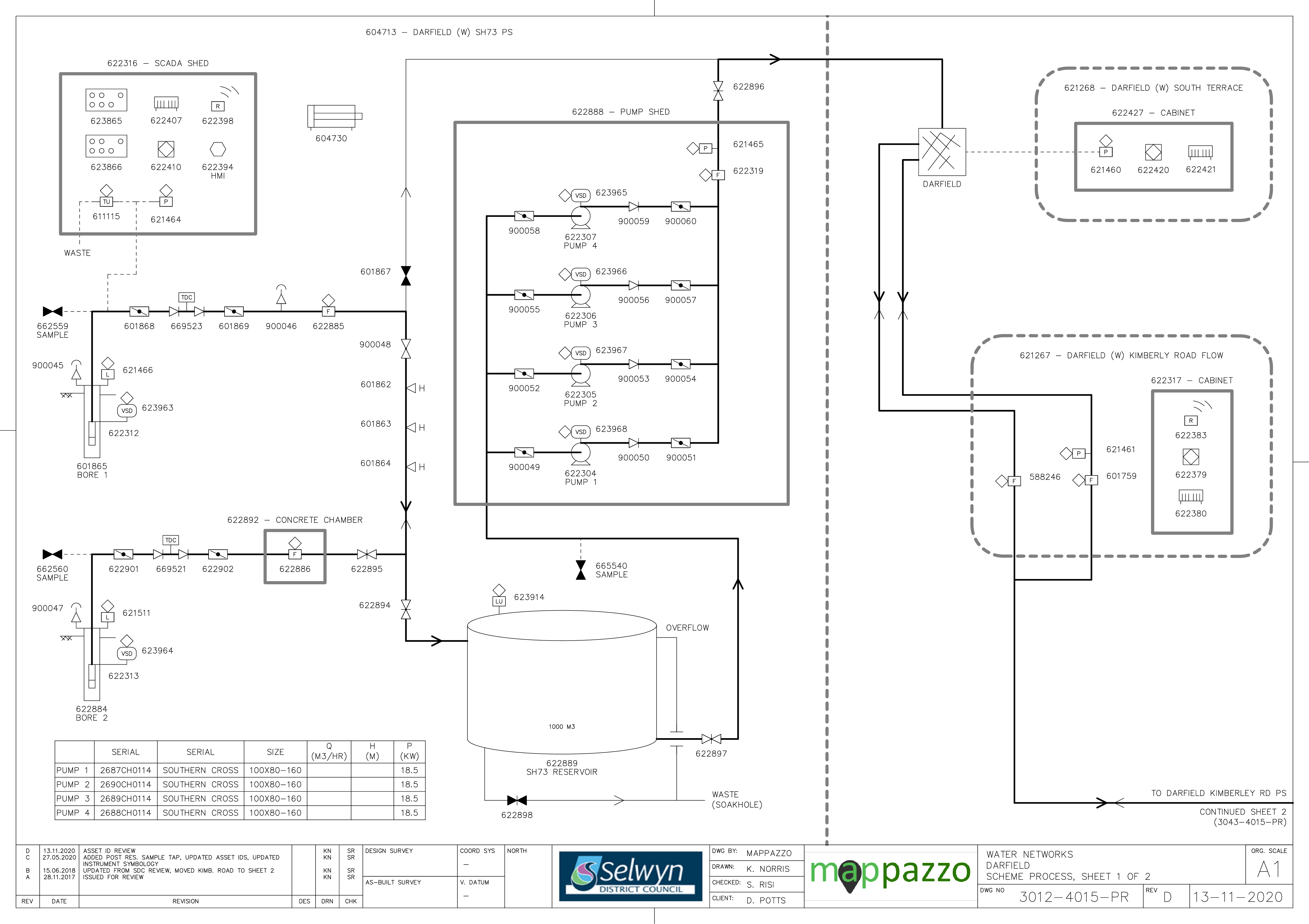
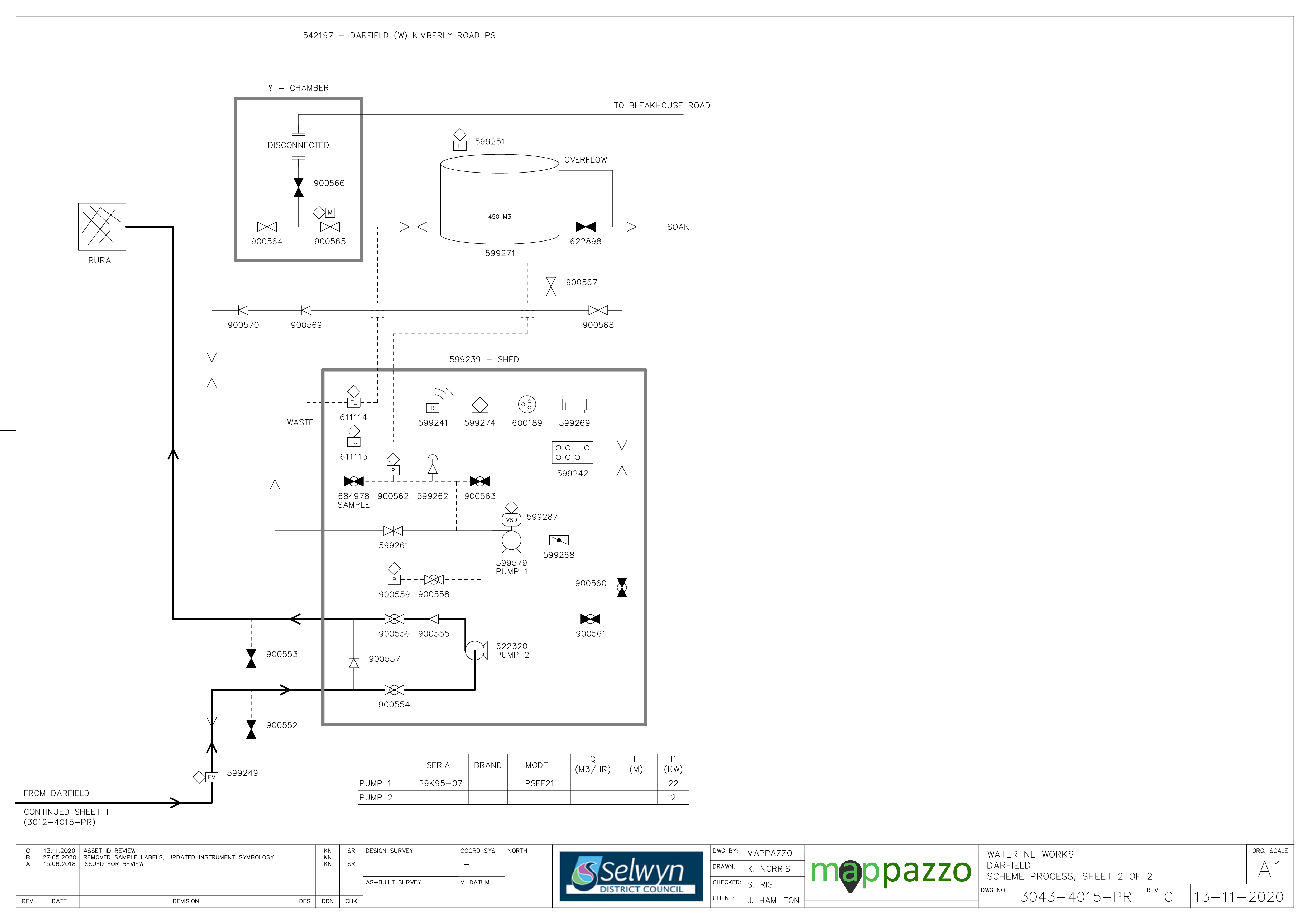
Figure 6‑2 Scheme Schematic
6.4 System Capacity
Darfield is expected to experience growth in population and new connections over the next 30 years. This will result in an increase in water demand for Darfield. The predicted increase in demand (in accordance with the latest house projections) until 2051 is shown in Figure 6-3. This forecast includes a new commercial development with an assumed demand of 26.4 L/s (0.7 L/s per ha).
Hydraulic models have been used to plan future water infrastructure for Darfield, as part of a master planning exercise. The master planning provides an assessment of the sizing and timing of new infrastructure for new water sources (wells) and pipelines to service growth. Part of the master planning requires a water balance to be developed to forecast growth, using historical peak demand per household. The water balance forecasts the peak instantaneous flow per year versus the water resources available to determine the staging of new wells. The well staging assumes that one well is redundant for each water supply, to take into consideration maintenance of wells, planning/timing of new wells and security of supply i.e. to maintain average/peak demand. The master planning exercise has identified that two new wells be required in Darfield, in year 2027/28 and 2042/43 respectively (Table 6-3).
Two reservoirs (the Kimberley reservoir, 450m3, and the SH73 reservoir, 1000m3) play a vital role in meeting peak hour demand and providing security of supply in the event of loss to the SH73 well and pumps. There is little redundancy for Darfield, because the flow is constrained by the pumping capacity. The Council may consider an additional well in future to increase the resilience of this scheme, in addition to the wells required to meet growth.
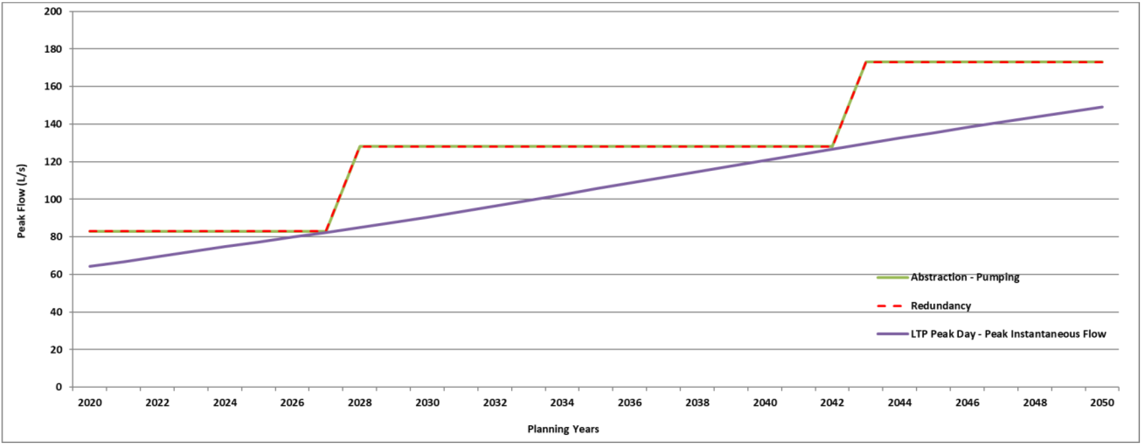
Figure 6‑3 Darfield Water Demand
Table 6‑2 Water Source Current Capacity
State Highway 73
| 1 | 63 | Maximum available flow 83 L/s from surface pumps |
State Highway 73
| 2 | 71 |
Table 6‑3 Water Source Future Capacity Required
| Darf1 | Creyke Road
| 2027/2028 (2021/22 Drilling)
| 45
|
| Darf2 | Creyke Road | 2042/2043
| 45
|
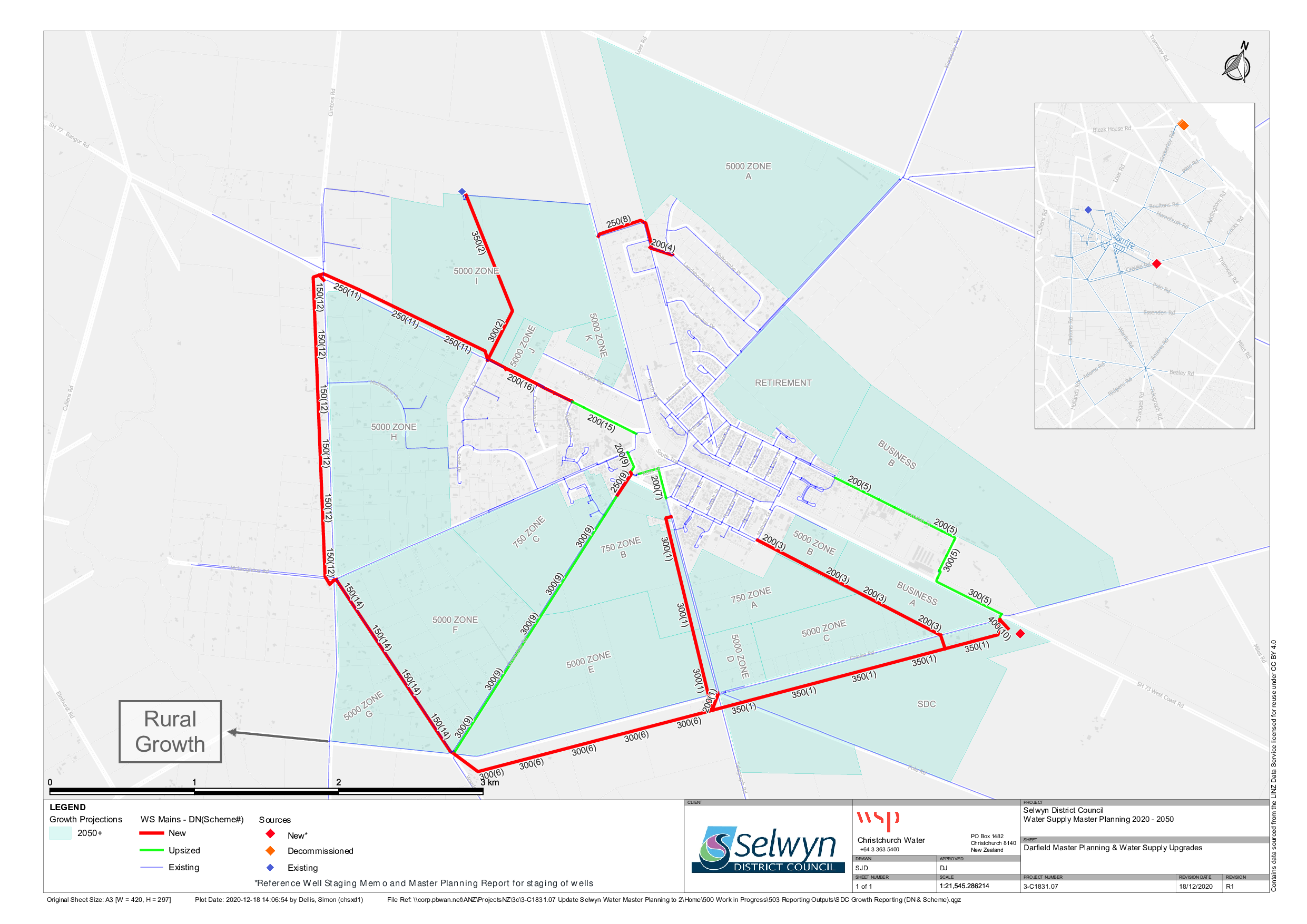
Figure 6‑4 Darfield Master Plan
6.5 Resource Consents
The Darfield water supply has a number of resource consents. Table 6‑4 shows the water take permitted by the resource consents for this scheme.
Table 6‑4 Resource Consents
CRC960148.1
| To take groundwater. | Old West Coast Road, DARFIELD | 29-Sep-09
| 29-Sep-30 | L35/0534
| 30
| 2,592
or
7,344 when combined with consents CRC991423 and CRC143985
|
CRC143985
| To take and use groundwater for the purposes of community supply. | Bangor Road, DARFIELD | 28-Mar-14
| 16-Nov-45 | L35/0980
BX22/0006
| 83 (combined rate)
| 6,000
or
7,344 when combined with consents CRC991423 and CRC960148
|
CRC991423
| To take and use water for public supply - Waimakariri river flow | Waimakariri River Bed, BLEAK HOUSE ROAD | 9-Sep-04 | 8-Sep-39 | Waimakariri River shallow bores L35/0176 and L35/0245 and L35/0534
| 85 (combined rate)
Depending on river flows | 5,460 (combined)
Depending on river flows;
Cannot be exercised concurrently with consent CRC960148 |
CRC991604
| To divert water for the water supply wells at Bleak House Road | Waimakariri River Bed, BLEAK HOUSE ROAD | 9-Sep-04 | 8-Sep-39 | N/A
Diversion of water from Waimakariri River Bed to water supply wells
| Combined with CRC991423 | Combined with CRC991423 |
6.6 Water Quality
The Darfield water supply is currently deemed to be a secure source. Sampling is conducted monthly within the treatment plant and weekly within the reticulation. Darfield also has a back-up supply (from the Waimakariri River) which is only tested if used - the results below only reflect testing from the SH73 deep bores.
The following details E. coli transgressions for the sample periods 2012 to 2020. There has been no E. coli identified in sampling at both of the SH73 bores.
Treatment
There have been no E. coli treatment transgressions during this period.
Zone
There have been two E. coli zone transgressions during this period. These occurred in August 2012 and December 2013.
Chemical Analysis
The following is a summary of the raw water chemical analysis carried out at the Darfield Water Supply. As both wells source water from the same aquifer, only one well is sampled.
Table 6‑5 Raw Water Chemical Analysis Darfield Water Supply
| Total Lead (g/m3) | 0.01 (Maximum Acceptable Value)
| 0.00132 | 0.000373
| 0.000209
| 0.000172
| ✓ |
| pH (pH units) | 7-8.5 (Guideline Value)
| 7.8 | 7.7 | 7.6
| 7.7
| ✓
|
| Total Hardness (g/m3 as CaCO3) | <200 (Guideline Value)
| 62 | 54.5 | 57.2
| 56.0
| ✓ |
| Total Calcium (g/m3) | n/v | 21 | 18.64 | 19.66
| 19.17
| ✓ |
| Total Iron (g/m3) | <0.2 (Guideline Value)
| <0.021 | < 0.021 | <0.021
| <0.021
| ✓
|
| Total Sodium (g/m3) | <200 (Guideline Value)
| 9.8 | 9.56 | 10.08
| 9.67
| ✓
|
| Nitrate - Nitrogen (g/m3) | 11.3 (Maximum Acceptable Value)
| 5.8 | 4.99 | 5.30
| 5.02
| ✓
|
6.7 Scheme Assets
A summary of material and diameter for pipes in Darfield is shown below by Figure 6‑5 and Figure 6‑6.
Figure 6‑5 Pipe Material – Darfield
Figure 6‑6 Pipe Diameter – Darfield
6.8 Operational Management
The water supply is operated and maintained under two maintenance contracts as follows:
- Contract 1241: Water Services Contract. Contract is with SICON who undertakes investigations, conditions inspections, proactive and reactive maintenance and minor asset renewals; and
-
Contract 1202: Parks and Reserves Contract. Contract is with SICON who undertakes the maintenance of land scape features related to water services e.g. mowing, gardens etc.
Water quality sampling is completed under an agreement with Food and Health Ltd as required.
6.9 Photos of Main Assets
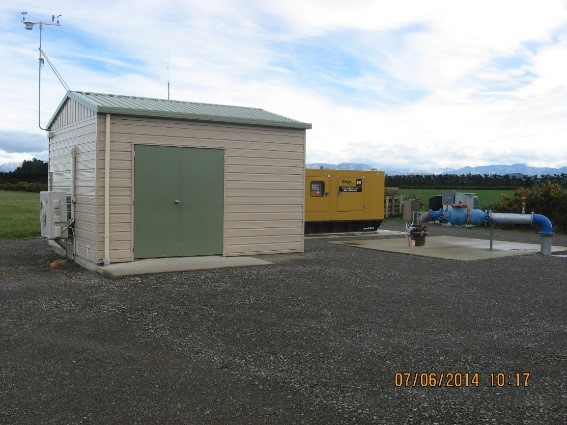
Photo 1: SH73 Bore No 1
| 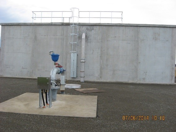
Photo 2: SH73 Bore No 2, Reservoir
|
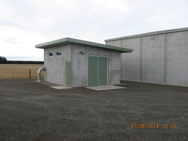
Photo 3: SH73 Booster Pump Shed and Reservoir
| 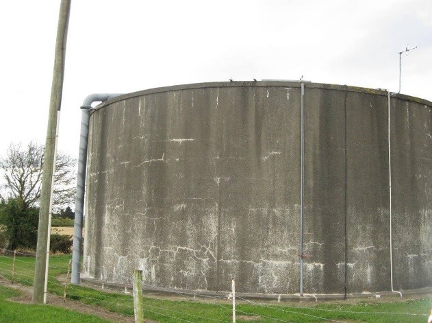
Photo 4: Kimberley Road Reservoir
|
6.10 Risk Assessment
A risk assessment has been undertaken for the Darfield scheme. The key output from the risk assessment is the identification of any extreme and high risks which need to be mitigated. In order to mitigate these risks they have been included and budgeted for in the projects within this LTP. Table 6‑6 outlines the risk priority rating, Table 6‑7 outlines the risks and the list of key projects is found in Table 6‑12.
Table 6‑6 Risk Priority Rating
| > 50 | Extreme | Awareness of the event to be reported to Council. Urgent action to eliminate / mitigate / manage the risk. Document risk and action in the AMP. |
| 35-50 | Very High | Risk to be eliminated / mitigated / managed through normal business planning processes with responsibility assigned. |
| 14-35 | High | Manage risk using routine procedures. |
| 3.5-14 | Moderate | Monitor the risk. |
| < 3.5 | Low | Awareness of the event to be reported to Council. Immediate action required to eliminate / mitigate / manage the risk. Document risk and action in the AMP. |
Table 6‑7 Risks – Darfield
| Failure of single pipe connection from source to township | Review options to include redundancy within the reticulated network with focus on linkages between the reservoir site and township. | 2014 | 40 | 40 | 20 |
| Failure of the main pipe from the reservoir would drain the Kimberly Rd reservoir | Install a 300mm non-return valve as a backflow provision at SH73 on or near the Haldon Street corner | 2014 | 40 | 40 | 40 |
| Lack of capacity for the growth in Darfield | Install additional bores for capacity in the future | 2014 | 45 | 45 | 20 |
| Lack of capacity for the growth in Darfield | Investigate the pump operations, to allow both wells to run at the same time, need power cable upgrade | 2014 | 45 | 45 | 20 |
| No reservoir turnover/usage at Kimberly road | Review Reservoir turnover and upgrade controls including auto flushing as required | 2014 | 20 | 3.5 | 3.5 |
| Unmarked critical water infrastructure could be damaged by others causing system failure | Install marker posts | 2014 | 40 | 20 | 20 |
| Electrical failure due to lightning or network spikes | Install surge diverters | 2014 | 20 | 7 | 7 |
| Failure to meet NES water meter standards | NES Water Meter Compliance | 2014 | 20 | 6 | 6 |
| Inability to collect income from non-metered properties | Install property water meters | 2014 | 45 | 0.6 | 0.6 |
| Non-compliance with the DWSNZ | DWSNZ - Age Testing | 2014 | 20 | 0.7 | 0.7 |
| Non-compliance with the DWSNZ | DWSNZ - Bore-head security | 2014 | 20 | 20 | 20 |
| Non-consented activities | Renewal of consents | 2014 | 27 | 27 | 6 |
| pump failure long lead time for pump | Spare pump | 2017 | | 6 | 2.1 |
The list of district wide risks can be found in 5Waters Activity Management Plan: Volume 1.
6.11 Asset Valuation Details
The total replacement value of assets within the Darfield water scheme is $22,277,512.91 with further details in Table 6‑8 below.
Table 6‑8 Replacement Value, Darfield
Plant and Equipment
| $3,599,100
|
Water Reticulation
| Hydrant | $464,134
|
Lateral
| $625,949
|
| Pipe | $15,901,984
|
| Supply Point | $1,227,391
|
| Valve | $458,955
|
6.12 Renewals
The renewal profile has been taken from the 2019 5 Waters Valuation. A graph showing the renewals for this scheme is shown in Figure 6‑7 below. The majority of renewals occur in
2020/2021.
Figure 6‑7 Darfield Water Renewal Profile
6.13 Critical Assets
The criticality model for Darfield has been updated for the 2021 AcMP. The methodology of the criticality model can be found in 5Waters Activity Management Plan: Volume 1 and it provides details of how the criticality has been calculated for the reticulation assets. Table 6‑9 and Figure 6‑8 below shows the calculated criticality for all of the assets within this scheme that have a recorded known length.
Table 6‑9 Length of Assets per Criticality Level
5
| Low | 105,718
|
4
| Medium-Low | 28,862
|
3
| Medium | 13,694
|
2
| Medium-High | 14,625
|
1
| High | 3,709
|
6.14 Asset Condition
The asset condition model was run for Darfield in 2021. The methodology of the model can be found in 5Waters Activity Management Plan: Volume 1 which provides details of how the model has been calculated for the pipe reticulation assets. Figure 6‑9 below shows the level of asset condition for these assets within this scheme that have a recorded known condition.
Table 6‑10 provides a description of the condition rating used within the condition model.
Table 6‑10 Asset Condition Grading
| 1.0 | Excellent |
| 2.0 | Good |
| 3.0 | Moderate |
| 4.0 | Poor |
| 5.0+ | Fail |
The number of pipe faults is also measured through the asset management system. Figure 6‑10 shows the known historic pipe failures within this scheme.
6.15 Funding Program
The 10 year budgets for Darfield are shown by Table 6‑11. Budgets are split into expenditure, renewals, projects and capital projects.
Expenditure and renewals have been reported on a district-wide basis in Volume 1.
All figures are ($) not adjusted for CPI “inflation". They are calculated on historical data, and population growth where relevant.
Table 6‑11 Darfield Budget Summary
| 2021/2022 | $25,000
| $1,008,510
|
| 2022/2023 | -
| $686,150
|
| 2023/2024 | -
| $387,930
|
| 2024/2025 | -
| -
|
| 2025/2026 | -
| -
|
| 2026/2027 | -
| -
|
2027/2028
| -
| -
|
2028/2029
| -
| -
|
2029/2030
| -
| -
|
2030/2031
| -
| -
|
Total
|
$25,000
| $2,082,590
|
An explanation of the categories within the budgets are as follows below:
-
Expenditure consists of operation and maintenance costs;
-
Renewals are replacement of assets which are nearing or exceeded their useful life;
-
Projects are investigations, decisions and planning activities which exclude capital works; and
-
Capital projects are activities involving physical works.
There are a number of major projects for Darfield water scheme in the LTP budget.
Table 6‑12 Key Projects
| Capital Projects | 401590001 | Darfield Water Supply Upgrades
| $1,008,510
| $336,150
| $187,930
| -
| 100% Growth
|
Capital Projects
| TBC
| Connect bottom end of Sheffield reticulation to Darfield scheme to improve turnover of Kimberley reservoir
| -
| -
| $200,000
| -
| 100% LoS
|
Capital Projects
| TBC
| Additional small reservoir at Kimberley Road to allow maintenance; pressure sensors; pipe upgrades
| -
| $100,000
| -
| -
| 100% LoS
|
Capital Projects
| TBC
| RPZ backflow devices between urban and rural parts of reticulation
| -
| $250,000
| -
| -
| 100% LoS
|
* Where LoS refers to Level of Service and G refers to Growth
The list of district wide projects can be found in 5Waters Activity Management Plan: Volume 1.
Discussion on Projects
Projects have been determined based on their:
- Relevance to the scheme
- Requirement to be completed under legislation
- Ability to bring the scheme up to or maintain the Level of Service required under council's Asset Management Policy.
Many projects are
jointly funded by more than one scheme and activity. Each scheme pays a pro-rata share only, equivalent to the number of connections.
Discussion on Capital and Projects
Where relevant, Capital (Levels of Service) and Capital (Growth) projects have been included in the scheme financial details.
Levels of Service Projects and growth splits have been provided to ensure the costs of population driven works are clear.
<< 5-Waters Volume 2 - Water Supplies