<<
5-Waters-Volume-4-Stormwater
16 Southbridge Stormwater Scheme
16.1 Scheme Summary
Scheme Area
| 155.91 ha |
| Scheme Coverage (as at 1 Jan 2021) | Rating numbers | 366
|
System components
| Piped (m) | 3,070
|
| Swales (m) | 1,521
|
| Drains (m) | 1,976
|
| Manholes/Inspection Chambers (No.) | 21
|
| Treatment | 1 basin
|
| Other | 1 soakhole
|
Value ($)
| Replacement Cost | $1,034,558
|
| Depreciated Replacement Cost | $797,243
|
| Financial | Operator cost (scheduled and reactive maintenance) per connection
| $14.97/connection
|
Planning
| Stormwater Management Plan | Draft
|
| No. SDC stormwater consents | 1
|
Demand
| Mean Annual Rainfall (mm) | 613 |
| 10% AEP (10 year) 1hr rainfall depth (mm) | 18.6 |
| Sustainability | Sustainable drain management practices | Adopted and Encouraged |
16.2 Key Issues
The following key issues are associated with the Southbridge Stormwater Scheme. A list of district wide issues are located in 5Waters Activity Management Plan: Volume 1.
Table 16‑1 Southbridge Scheme Issues
| Flooding of properties on O'Connell Street from run off from the upper catchment. | Continue to work with the community to identify affordable solutions. |
| Changing community expectations regarding levels of service and funding of stormwater services. | Continue to work with the community to prioritise improvement programme. |
16.3 Overview & History
There are limited stormwater records for the Southbridge township. Ultimate discharge of stormwater runoff is to the Waikekewai Creek / Lee Stream. Water races fed from the Lower Rakaia have historically run through the township. The flood waters are often conveyed by these remnant channels.
Flooding
Flooding occurred in Southbridge in 2013 as a result of 254 mm rain during June. Overland flow from paddocks affected O'Connell Street and other areas impacted included Bowen, Sarsfield and St. John Street.
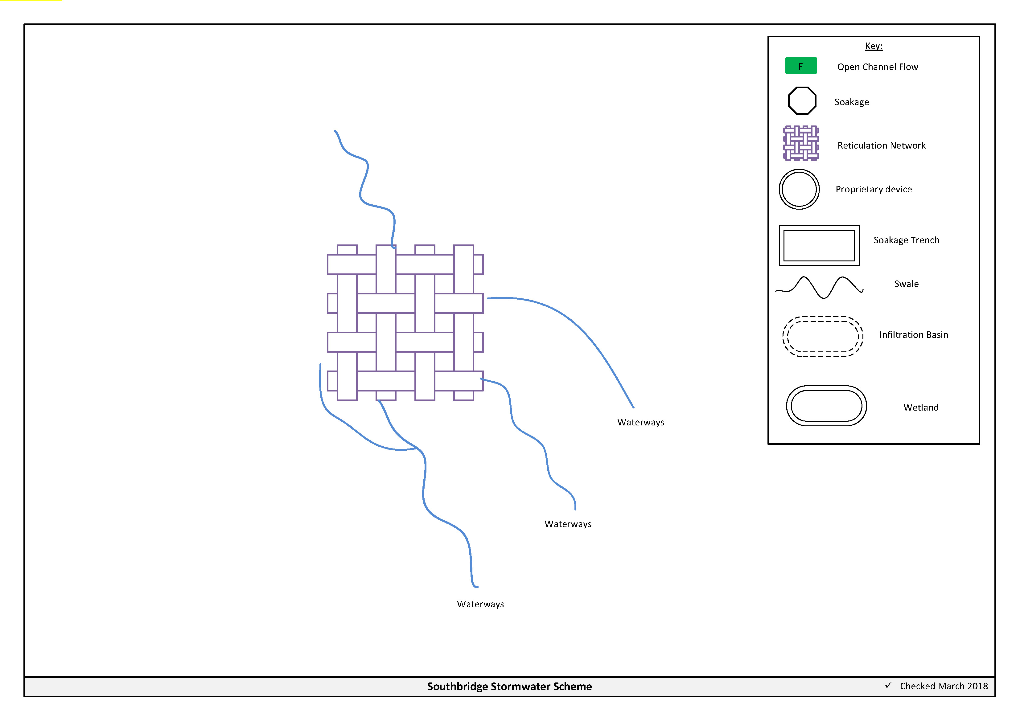
Figure 16‑2 Scheme Schematic
16.4 Resource Consents
Council have applied for a global consent for the Southbridge stormwater scheme (Table 16-2). The application is underway with ECan.
Table 16‑2 Resource Consents
CRC167470
Application in Process | to discharge stormwater from the existing stormwater network of Southbridge | Southbridge, Selwyn | TBC
| TBC
|
16.5 Integrated Stormwater Management Plan
An Integrated Stormwater Management Plan has been prepared for Southbridge and submitted to ECan, as part of the application for consent CRC167470.
16.6 Scheme Assets
Council has a wide variety of stormwater assets within the district. A brief description of the assets within this scheme is provided below:
a. Swale (Grassed) – Is a longitudinal open channel which is lined with grass. The swale both conveys and treats stormwater.
b. Reticulated network – Includes pipes, manholes, sumps. The primary purpose of the reticulated network is to collect and convey stormwater. Historically these systems were designed for the 2 year storm event. Today's engineering standards require the piped network to be designed for a 10 year event with overland flow provision for up to the 50 year event.
c. Soakholes – Are used to dispose of stormwater to ground in areas where the ground water table is low and soil permeability is high.
d. Open drains – are channels used to convey stormwater. They are cost effective means to convey large volumes of water.
A summary of material and diameter for channels and pipes, where known, is shown below in Figure 16‑3 and Figure 16‑4.
Figure 16‑3 Pipe Material - Southbridge
Figure 16‑4 Pipe Diameter – Southbridge
16.7 Operational Management
The stormwater network is operated and maintained under two maintenance contracts as follows:
- Contract 1241: Water Services Contract. Contract is with SICON who undertakes investigations, conditions inspections, proactive and reactive maintenance and minor asset renewals.
- Contract 1202: Parks and Reserves Contract. Contract is with SICON who undertakes the maintenance of land scape features related to water services e.g. mowing, gardens etc.
Water quality sampling is completed under an agreement with Food and Health Ltd as required.
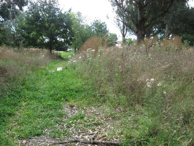
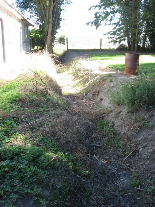
16.8 Photos of Main Assets
|
|
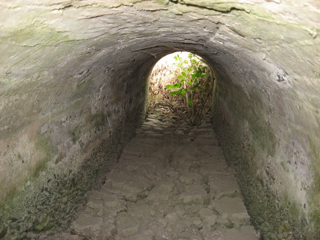
Photo 1, 2 & 3: Flood conveyance swales
|
16.9 Rapid Flood Modelling
The Council has undertaken 'Rapid Flood Hazard Assessment' modelling for its main townships. The modelling uses DHI MIKE 21 to simulate rainfall on grid with the outputs processed through ArcGIS producing maps illustrating a range of flood deeps during different rainfall intensities and durations.
The rapid flood assessment has been generated to provide a high level summary of potential flood and ponding areas across the district during extreme rainfall events. The results from this study are not to be used to set floor levels. The results have not been ground tested and therefore are indicative only.
For a 50 year event, Figure 16‑5 shows the predicted flooding for Southbridge.

Figure 16‑5 Rapid Flood Modelling, Southbridge
16.10 Risk Assessment
A risk assessment has been undertaken for the Southbridge scheme. The key output from the risk assessment is the identification of any extreme and high risks which need to be mitigated. In order to mitigate these risks they have been included and budgeted for in the projects within this LTP. Table 16‑3 details the risk priority rating, Table 16‑4 outlines the risks and the list of key projects is found in Table 16‑9.
Table 16‑3 Risk Priority Rating
| > 50 | Extreme | Awareness of the event to be reported to Council. Urgent action to eliminate / mitigate / manage the risk. Document risk and action in the AMP. |
| 35-50 | Very High | Risk to be eliminated / mitigated / managed through normal business planning processes with responsibility assigned. |
| 14-35 | High | Manage risk using routine procedures. |
| 3.5-14 | Moderate | Monitor the risk. |
| < 3.5 | Low | Awareness of the event to be reported to Council. Immediate action required to eliminate / mitigate / manage the risk. Document risk and action in the AMP. |
Table 16‑4 Risks - Southbridge
| Flooding of O'Connell Street properties from the upper catchment | Develop stormwater strategy | 2014 | 3.5 | 3.5 | 3.5 |
| Lack of asset data | Collect asset data | 2014 | 4 | 4 | 2 |
| Changing expectations as new residents move to Southbridge | Define approprate LoS Stormwater | 2014 | 12 | 12 | 6 |
| Non-consented activities | Renewal of consents | 2014 | 27 | 27 | 6 |
| Stormwater management | Master plan work | 2017 | | 6 | 2.1 |
The list of district wide risks can be found in 5Waters Activity Management Plan: Volume 1.
16.11 Asset Valuation Details
The total replacement value of assets within the Southbridge Scheme is $1,034,558 as detailed in Table 16‑5 below.
Table 16‑5 Replacement Value, Southbridge
Stormwater Reticulation
| Channel | $144,774
|
| Inlet-Outlet-Point | $41,541
|
| Lateral | $62,763
|
| Manhole | $124,921
|
| Pipe | $660.559
|
16.12 Renewals
The renewal profile has been taken from the 2019 5 Waters Valuation. A graph showing the renewals for this scheme are shown by Figure 16‑6 below. The majority of assets requiring renewal are culverts/pipes which occur in the year 2040/41.
Figure 16‑6 Southbridge Stormwater Renewal Profile
16.13 Critical Assets
The criticality model for Southbridge has been updated for the 2021 AcMP. The methodology of the criticality model can be found in 5Waters Activity Management Plan: Volume 1 and it provides details of how the criticality has been calculated for the reticulation assets. Table 16‑6 and Figure 16‑7 below show the calculated criticality for all of the assets within this scheme that have a recorded known length.
Table 16‑6 Length of Assets per Criticality Level
5
| Low | 4,124
|
4
| Medium-Low | 921
|
3
| Medium | 272
|
2
| Medium-High | 0 |
1
| High | 0 |
16.14 Asset Condition
The asset condition model was run for Southbridge in 2021. The methodology of the model can be found in 5Waters Activity Management Plan: Volume 1 and it provides details of how the model has been calculated for the reticulation assets (particularly pipes). Figure 16‑8 below shows the level of asset condition for all of the assets within this scheme that have a recorded known condition.
Table 16‑7 provides a description of the condition rating used within the condition model.
Table 16‑7 Asset Condition Grading
| 1.0 | Excellent |
| 2.0 | Good |
| 3.0 | Moderate |
| 4.0 | Poor |
5.0+
| Fail |
16.15 Funding Program
The 10 year budgets are shown by Table 16‑8. Budgets are split into expenditure, renewals, projects and capital projects. Expenditure and renewals have been reported on a district-wide basis in Volume 1.
All figures are ($) not adjusted for CPI “inflation". They are calculated on historical data, and population growth where relevant.
Table 16‑8 Budget Summary
| 2021/2022 | -
| $30,000
|
2022/2023
| -
| $30,000
|
| 2023/2024 | -
| -
|
| 2024/2025 | -
| -
|
| 2025/2026 | -
| -
|
| 2026/2027 | -
| -
|
| 2027/2028 | -
| - |
2028/2029
| -
| -
|
2029/2030
| -
| -
|
2031/2032
| -
| -
|
| Total | -
| $60,000
|
An explanation of the categories within the budgets are as follows below:
-
Expenditure consists of operation and maintenance costs;
-
Renewals are replacement of assets which are nearing or exceeded their useful life;
-
Projects are investigations, decisions and planning activities which exclude capital works; and
-
Capital projects are activities involving physical works.
Table 16‑9 Key Projects
Capital Projects
| -
| Roberson reserve
| -
| $30,000
| -
| -
| 100% LoS
|
Capital Projects
| -
| St John Street overland flow
| $30,000
| -
| -
| -
| 100% LoS
|
* Where LoS refers to Level of Service and G refers to Growth
The list of district wide projects can be found in 5Waters Activity Management Plan: Volume 1.
Discussion on Projects
Projects have been determined based on their:
- Relevance to the scheme
- Requirement to be completed under legislation
- Ability to bring the scheme up to or maintain the Level of Service required under council's Asset Management Policy.
Many projects are jointly funded by more than one scheme and activity. Each scheme pays a pro-rata share only, equivalent to the number of connections.
Discussion on Capital and Projects
Where relevant, Capital (Levels of Service) and Capital (Growth) projects have been included in the scheme financial details.
Levels of Service Projects and growth splits have been provided to ensure the costs of population driven works are clear.
<<
5-Waters-Volume-4-Stormwater