<<
5-Waters-Volume-4-Stormwater
14 Rakaia Huts Stormwater Scheme
14.1 Scheme Summary
Scheme Area
| 27.72 ha |
| Scheme Coverage (as at 1 Jan 2021) | Rating numbers | 114
|
System components
| Piped (m) | 680
|
| Swales (m) | 0
|
| Drains (m) | 0
|
| Manholes/Inspection Chambers (No.) | 7
|
| Treatment | N/A |
| Other | N/A |
Value ($)
| Replacement Cost | $281,448
|
| Depreciated Replacement Cost | $195,035
|
Financial
| Operator cost (scheduled and reactive maintenance) per connection
| $4.26/connection
|
Planning
| Stormwater Management Plan | Not required |
| No. SDC stormwater consents | 1
|
Demand
| Mean Annual Rainfall (mm) | 613 |
| 10% AEP (10 year) 1hr rainfall depth (mm) | 18.6 |
| Sustainability | Sustainable drain management practices | Adopted and Encouraged |
14.2 Key Issues
The following key issues are associated with the Rakaia Huts Stormwater Scheme. A list of district wide issues are located in 5Waters Activity Management Plan: Volume 1.
Table 14‑1 Rakaia Huts Scheme Issues
| Flooding from upper catchment | Development of a stormwater catchment plan. |
14.3 Overview & History
The stormwater system is a pipe network which mainly services the Ocean View Place catchment. Stormwater is conveyed by the pipe network discharging to the coastal environment.
Foreshore Protection
An area of foreshore at the end of Pacific Drive is subject to coastal erosion. Council were asked in 2013 to undertake protection works to the foreshore. The land is crown land managed by the Department of Conservation. In general terms Environment Canterbury is responsible for coastal erosion however there is no requirement to provide such protection. Coastal protection measures have previously been undertaken by the community. Little Rakaia Boating club hold the consent for the boat ramp and are responsible for its maintenance.
Rakaia River Mouth Opening
Flooding and property damage occurred in Rakaia Huts in 1992, 2008 and 2012 as a result of heavy rainfall in the headwaters and location of the river mouth. Environment Canterbury is working towards lodging a global consent to manage rivers in Canterbury including the Rakaia River mouth. This process has yet to be completed and as a result interim process has been put in place to open the Rakaia River mouth when there is potential to endanger property and life in Rakaia Huts. A standard operating procedure has been developed by Council for initiating the temporary river mouth opening procedure. Physical river mouth opening is undertaken by Environment Canterbury.
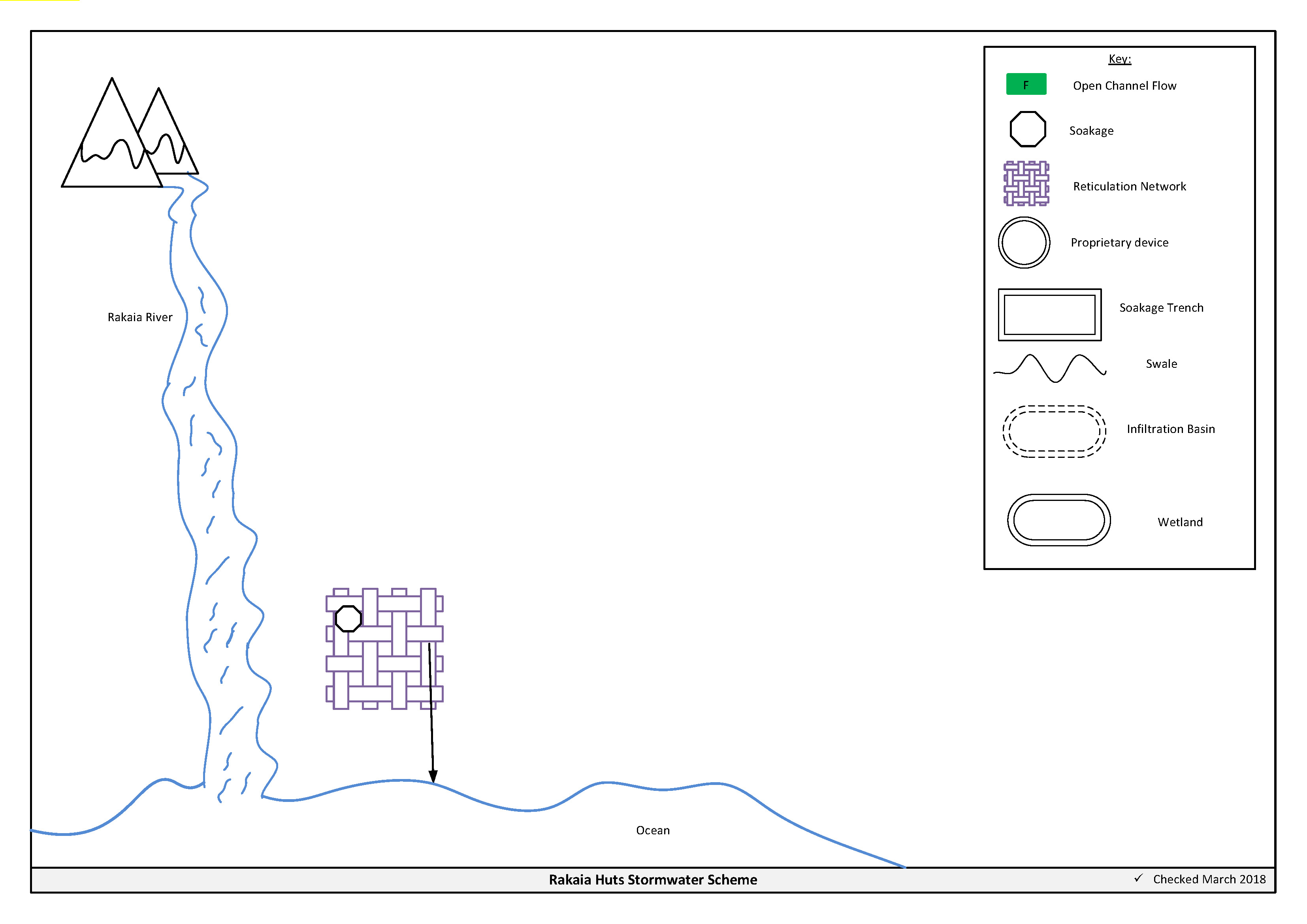
Figure 14‑2 Scheme Schematic
14.4 Resource Consents
Council have a certificate of compliance for the Rakaia Huts stormwater scheme (Table 14-2). The activity is permitted under Rule 7.1 of the Regional Coastal Environment Plan for the Canterbury Region, subject to conditions.
Table 14-2 Certificate of Compliance
CRC175956
| To discharge stormwater into the Coastal Marine Area.
| Rakaia Huts Township
| 6/6/2017
| N/A
|
14.5 Integrated Stormwater Management Plan
An integrated stormwater management plan is not required for Rakaia Huts at this time.
14.6 Scheme Assets
Council has a wide variety of stormwater assets within the district. A brief description of the assets within this scheme is provided below:
a. Reticulated network – Includes pipes, manholes, sumps. The primary purpose of the reticulated network is to collect and convey stormwater. Historically these systems were designed for the 2 year storm event. Today's engineering standards require the piped network to be designed for a 10 year event with overland flow provision for up to the 50 year event.
A summary of material and diameter for channels and pipes, where known, is shown below in Figures 14‑3 and 14-4.
Figure 14‑3 Pipe Material – Rakaia Huts
Figure 14‑4 Pipe Diameter – Rakaia Huts
14.7 Operational Management
The stormwater network is operated and maintained under two maintenance contracts as follows:
- Contract 1241: Water Services Contract. Contract is with SICON who undertakes investigations, conditions inspections, proactive and reactive maintenance and minor asset renewals.
- Contract 1202: Parks and Reserves Contract. Contract is with SICON who undertakes the maintenance of land scape features related to water services e.g. mowing, gardens etc.
Water quality sampling is completed under an agreement with Food and Health Ltd as required.
14.8 Photos of Main Assets
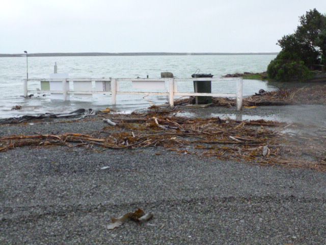
Photo 1: Rakaia River in flood
|
14.9 Rapid Flood Modelling
The Council has undertaken 'Rapid Flood Hazard Assessment' modelling for its main townships. The modelling uses DHI MIKE 21 to simulate rainfall on grid with the outputs processed through ArcGIS producing maps illustrating a range of flood deeps during different rainfall intensities and durations.
The rapid flood assessment has been generated to provide a high level summary of potential flood and ponding areas across the district during extreme rainfall events. The results from this study are not to be used to set floor levels. The results have not been ground tested and therefore are indicative only.
For a 50 year event, Figure 14-4 shows the predicted flooding for Rakaia Huts.

Figure 14‑5 Rapid Flood Assessment, Rakaia Huts
14.10 Risk Assessment
A risk assessment has been undertaken for the Rakaia Huts scheme. The key output from the risk assessment is the identification of any extreme and high risks which need to be mitigated. In order to mitigate these risks they have been included and budgeted for in the projects within this LTP. Table 14‑3 details the risk rating priority and Table 14‑4 outlines the risks for this scheme.
Table 14‑3 Risk Priority Rating
| > 50 | Extreme | Awareness of the event to be reported to Council. Urgent action to eliminate / mitigate / manage the risk. Document risk and action in the AMP. |
| 35-50 | Very High | Risk to be eliminated / mitigated / managed through normal business planning processes with responsibility assigned. |
| 14-35 | High | Manage risk using routine procedures. |
| 3.5-14 | Moderate | Monitor the risk. |
| < 3.5 | Low | Awareness of the event to be reported to Council. Immediate action required to eliminate / mitigate / manage the risk. Document risk and action in the AMP. |
Table 14‑4 Risks – Rakaia Huts
| Storm surges block pipe | Review culvert outlet design from Camping ground | 2014 | 4 | 2 | 2 |
| Non-consented activities | Renewal of consents | 2014 | 27 | 27 | 6 |
The list of district wide risks can be found in 5Waters Activity Management Plan: Volume 1.
14.11 Asset Valuation Details
The total replacement value of assets within the Rakaia Huts Scheme is $268,750 as detailed in Table 14‑5 below.
Table 14‑5 Replacement Value, Rakaia Huts
Stormwater Reticulation
| Inlet-Outlet-Point | $870
|
| Lateral | $34,323
|
| Manhole | $49,308
|
| Pipe | $196,947
|
14.12 Renewals
The renewal profile has been taken from the 2019 5Waters Valuation. There are no renewals scheduled for this scheme.
14.13 Critical Assets
The criticality model for Rakaia Huts has been updated for the 2021 AcMP. The methodology of the criticality model can be found in 5Waters Activity Management Plan: Volume 1 and it provides details of how the criticality has been calculated for the reticulation assets. Table 14‑6 and Figure 14‑6 below show the calculated criticality for all of the assets within this scheme that have a recorded known length.
Table 14‑6 Length of Assets per Criticality Level
5
| Low | 666 |
4
| Medium-Low | 0 |
3
| Medium | 0 |
2
| Medium-High | 0 |
1
| High | 0 |
14.14 Asset Condition
The asset condition model was run for Rakaia Huts in 2021. The methodology of the model can be found in 5Waters Activity Management Plan: Volume 1 and it provides details of how the model has been calculated for the reticulation assets (particularly pipes). Figure 14‑7 below shows the level of asset condition for all of the assets within this scheme that have a recorded known condition.
Table 14‑7 provides a description of the condition rating used within the condition model.
Table 14‑7 Asset Condition Grading
| 1.0 | Excellent |
| 2.0 | Good |
| 3.0 | Moderate |
| 4.0 | Poor |
| 5.0+ | Fail |
14.15 Funding Program
The 10 year budgets are shown by Table 14‑8. Budgets are split into expenditure, renewals, projects and capital projects. Expenditure and renewals have been reported on a district-wide basis in Volume 1.
All figures are ($) not adjusted for CPI “inflation". They are calculated on historical data, and population growth where relevant.
Table 14‑8 Budget Summary
| 2021/2022 | $5,000
| -
|
2022/2023
| -
| -
|
| 2023/2024 | -
| $30,000
|
| 2024/2025 | -
| -
|
| 2025/2026 | -
| -
|
| 2026/2027 | -
| -
|
| 2027/2028 | -
| - |
2028/2029
| -
| -
|
2029/2030
| -
| -
|
2031/2032
| -
| -
|
| Total | $5,000
| $30,000
|
An explanation of the categories within the budgets are as follows below:
-
Expenditure consists of operation and maintenance costs;
-
Renewals are replacement of assets which are nearing or exceeded their useful life;
-
Projects are investigations, decisions and planning activities which exclude capital works; and
-
Capital projects are activities involving physical works.
Table 14‑9 Key Projects
Capital Projects
| -
| Network upgrade
| -
| -
| $30,000
| -
| 100% LoS
|
Projects
| -
| Diversion of overland flow channel, driveway built up
| $5,000
| -
| -
| -
| 100% LoS
|
* Where LoS refers to Level of Service and G refers to Growth
The list of district wide projects can be found in 5Waters Activity Management Plan: Volume 1.
Discussion on Projects
Projects have been determined based on their:
- Relevance to the scheme
- Requirement to be completed under legislation
- Ability to bring the scheme up to or maintain the Level of Service required under council's Asset Management Policy.
Many projects are jointly funded by more than one scheme and activity. Each scheme pays a pro-rata share only, equivalent to the number of connections.
Discussion on Capital and Projects
Where relevant, Capital (Levels of Service) and Capital (Growth) projects have been included in the scheme financial details.
Levels of Service Projects and growth splits have been provided to ensure the costs of population driven works are clear.
<<
5-Waters-Volume-4-Stormwater