<<
5-Water-Volume-6-Water-Races
3 Paparua Water Races
3.1 Scheme Summary
| Scheme area (within scheme boundary) | 35,837 ha |
Scheme Coverage
(as at 1 Jan 2021)
| Area of Full Charges | |
| Unit Charge (No.) | 1355 |
| Irrigators | 59 |
Systems components
| Intakes | 1
|
| Main Race | 114.79 km |
| Local Race | 218.64 km |
| Lateral Race | 99.59 km |
| Other | 2 settling ponds |
| Water Source | via River | Waimakariri River (Paparua intake) |
| History | Install date | Installed progressively from 1885 |
Value ($)
| Replacement Cost | $23,140,131
|
| Depreciated Replacement Cost | $20,281,143
|
Financial
| Annual maintenance cost % of total water race maintenance spend
| $876,741/year
41% of total water race maintenance spend
|
Water Take
| Annual average (from Management Plan) | 41.3 million m3 |
| Consented Take | 2,031 Lts/sec (including irrigation) |
Sustainability
| Biodiversity | Groundwater recharge and natural habitat |
| Amenity | Urban features |
3.2 Key Issues
The following key issues are associated with the Paparua Water Race system. A list of district wide issues are located in 5Waters Activity Management Plan: Volume 1.
Table 3‑1 Paparua Scheme Issues
| Vandalism at the Paparua intake. | The Paparua intake is subject to ongoing vandalism which will be monitored and onsite improvements made where practical. |
| Health and Safety Risk | Health and Safety inspections and improvements |
| Operating race for biodiversity values will add financial pressure. | Review options for alternative funding. |
| Operating race for biodiversity values will add financial pressure. | An alternative rating structure is proposed which takes into account benefits of the race network other than stock water. The alternative rating structure is one of the matters included in the 2018-28 consultation document. |
3.3 Overview & History
The Paparua scheme serves a variety of smaller farms and a large number of lifestyle blocks. It consists of an intake on the southern bank of the Waimakariri River at Intake Road feeding into races, which fan out across the plains towards Christchurch in the East and Burnham in the south.
The intake although still within the flood plain of the river is a simple concrete weir with a vertical sluice gate on the protected southern branch of the river. The water is led to this channel as necessary after each major fresh or flood in the river. In a flood the intake is protected by a combination of willow plantings and the mechanism of the river in the active main flood plain area overtopping the low bank of the dozed channel and washing the weak portion downstream.
From the river, water is fed through an intake race for some 500 metres. This race then divides into two races leading to two sedimentation pond areas where most of the sand and silt is allowed to settle out before the water feeds into the scheme.
The scheme from here consists of a series of main and subsidiary races feeding water to properties throughout the scheme area which generally covers the area of the old Paparua County totalling approx. 35,000 hectares with 2,966ha of Christchurch City area served.
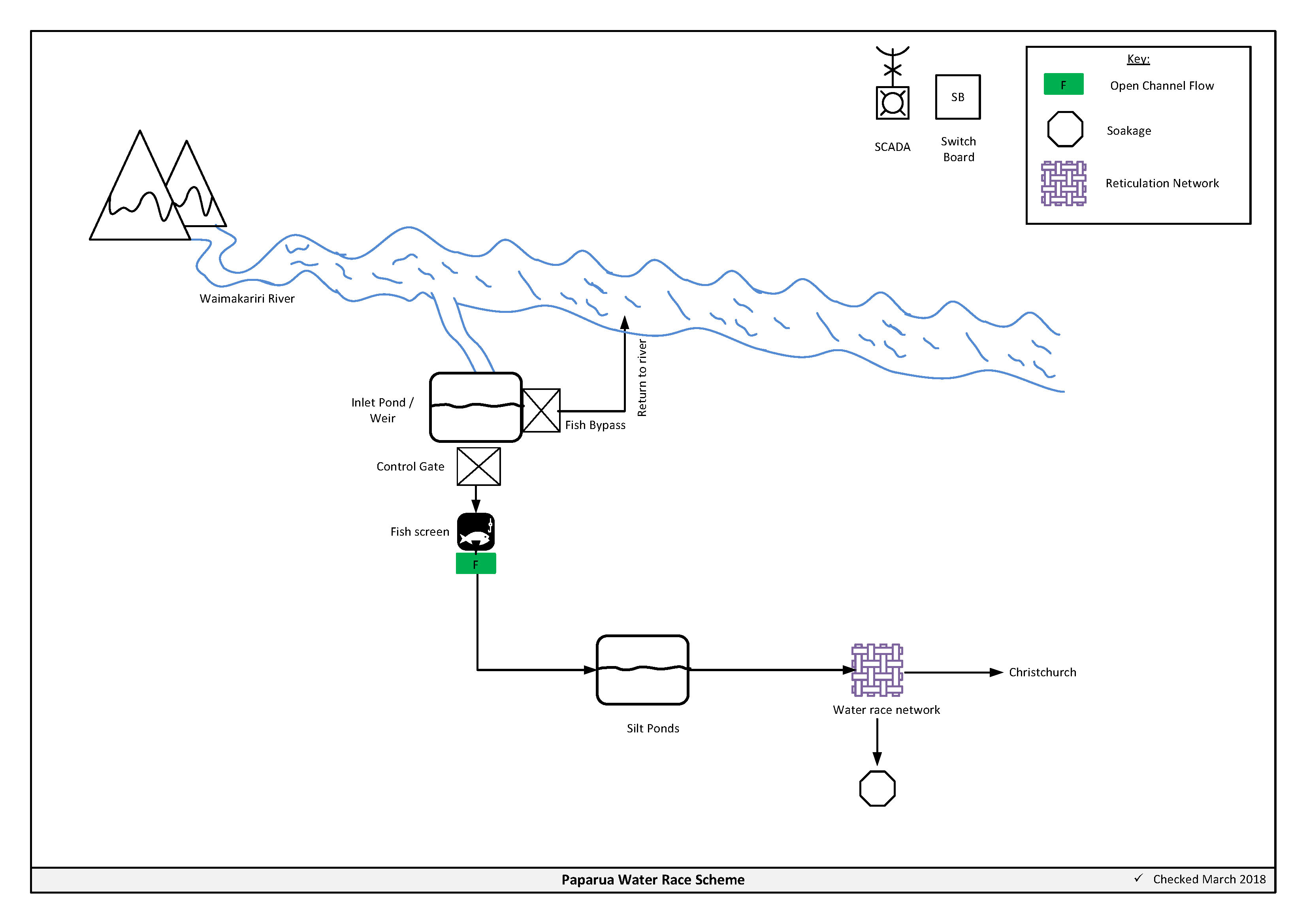
Figure 3‑2 Scheme Schematic
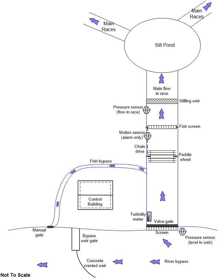
Figure 3‑3 Intake Scheme Schematic
3.4 Resource Consents
The Paparua water race scheme has a number of resource consents. Table 3‑2 shows that water takes permitted by the resource consents at the three intakes and Table 3‑3 details the resource consents for this scheme.
Table 3‑2 Allowable Take
| Intake Rd – Stock water | 1231 | 1331 |
| Intake Rd - Irrigation | 800 | 800 |
|
Total | 2,031 | 2,131 |
Table 3‑3 Resource Consents
| CRC012005 | To disturb the bed of the Waimakariri River to maintain intake and discharge structures | Stockwater Race Network | 10/12/2002 | 10/12/2037 | Issued - Active |
| CRC012006 | To take a maximum flow of 1430 litre per second from the Waimakariri River at the Waimakariri Gorge intake and to take a maximum flow of 800 litres per second from the Waimakariri River at the Paparua intake for stockwater and irrigation supply | Stockwater Race Network | 10/12/2002 | 10/12/2037 | Issued - Active |
| CRC012007 | To discharge water and water containing contaminants into land and/or water from the stockwater scheme at several points into drains and soakpits | Stockwater Race Network | 10/12/2002 | 10/12//2037 | Issued - Active |
CRC201738
| Global Consent - To discharge contaminants into water and onto land in circumstances where they may enter surface water
| Global Consent (Spraying)
| 25/01/2021 | 25/01/2036
| Issued - Active
|
CRC212849
| Global Consent - To discharge contaminants to air
| Global Consent (Spraying)
| 25/01/2021
| 25/01/2036
| Issued - Active
|
3.5 Water Quality
Under resource consent CRC012006 Council were required to undertake water quality sampling from May 2003 to December 2004. A summary of the results, sampled on 14 December 2004, is below in Table 3‑4.
Table 3‑4 Sampling Results
| Marshes Road NZMS 260 M36:7265-3663 | 2100 | 0.5 | 14 | 12 |
| Marshes Road NZMS 260 M36:7265-3664 | Dry | Dry | Dry | Dry |
| Marshes Road NZMS 260 M36:7265-3665 | Dry | Dry | Dry | Dry |
| Tosswill Road NZMS 260 M36: 7151-3512 | 300
| <0.05 | 13 | 28.4 |
| Tosswill Road NZMS 260 M36: 7151-3512 | Dry | Dry | Dry | Dry |
| Tosswill Road NZMS 260 M36: 7151-3512 | Dry | Dry | Dry | Dry |
| Lincoln Township NZMS 260 M36: 6832-3017 | 350 | 0.06 | 14 | 6.84 |
| Lincoln Township NZMS 260 M36: 6832-3017 | Dry | Dry | Dry | Dry |
| Lincoln Township NZMS 260 M36: 6832-3017 | Dry | Dry | Dry | Dry |
| Ellesmere Road NZMS 260 M36: 7036-3002 | Dry | Dry | Dry | Dry |
| Ellesmere Road NZMS 260 M36: 7036-3002 | Dry | Dry | Dry | Dry |
| Ellesmere Road NZMS 260 M36: 7036-3002 | Dry | Dry | Dry | Dry |
| Days Road NZMS 260 M36:6474-2834 | 4100 | 0.08 | 12 | 49.6 |
| Days Road NZMS 260 M36:6474-2834 | 400 | 0.19 | 11 | 14.17 |
| Days Road NZMS 260 M36:6474-2834 | 1600 | 0.09 | 10 | 42.1 |
3.6 Scheme Assets
3.6.1 Silt Ponds
There are two silt ponds, which are used to settle out river silt from the Waimakariri River in times of flood. The ponds are accessed through a locked gate about 100 metres from the river end of Intake Road. These ponds are situated about 1 kilometre below the Main Race Intake Control gates.
The first pond (1.23ha) is situated above the start of the Harewood Race and is the larger of the two ponds. The silt progresses down the main race to a wider channel section just before the pond and silt settles out in the channel.
The second pond (0.44ha) is smaller in size and the silt is allowed to settle in the pond itself and is cleaned out to bank. Pond number two has minimal storage. The race, known as the Sandy Knolls, leads away from this pond and supplies water to the Rolleston and Burnham area.
If there is a total outage, or gates are closed completely at the intake and there is no flow into the race system within 24 hours, the upper half of the Paparua Race system drops to a very low flow. After 24 hours of outage at the intake the whole upper half of the scheme will be out of water. The lower half of the Paparua scheme starts to be affected by lack of flow into the scheme.
3.6.2 Control Structures
Divides are on the main races below the main intake control gates. The divides are a mixture of single or multiple control gates sited where the main race flow requires splitting into equal or different flows. Each split race then goes on to serve a different area of the scheme.
3.6.3 Monitoring Points
Monitoring structures are sited below intakes to measure the quantity of water taken from the source. The main monitoring site is located immediately downstream of the intake and fish screen. The only other monitoring structures on the Paparua Water Race System are approximately 400 metres downstream of the main intake where there are two control gates that divide the flow into two races. They are used to measure flows to ensure compliance with resource consent requirements and to compile a history of the intake flow.
Each of these races has a section of race that has had its cross-sections calibrated by a certified hydrologist to enable measurement of the flows.
3.6.4 Emergency Discharge Points
There are discharge points on main races, and on some minor races, to dump surplus water from the race system. These are used in an emergency, or when work is required on a section of race, and can be dewatered using the emergency discharge point.
An emergency is when water has got into the race system from heavy rain causing. This water is required to be quickly removed from the system to prevent flooding at downstream culverts or overtopping and affecting roads, property, crops or buildings. This water can be removed from one discharge point or several, up to 3 to 4, depending on the amount of water to be removed. Also excess water may be taken from the race to buffer additional usage such as high irrigation and sudden shut down of the irrigation systems. Flood discharge points on the race system are sited at:
- Scout Camp on West Coast Road and Buchannan's Road intersection
- Old West Coast Road and Main West Coast Road intersection
- Sandy Knolls Road and Railway Road
- Newton's and West Melton Road intersection
3.6.5 Soakholes
Soakholes allow excess water to be taken from the intake to buffer additional usage such as high water use. Maximum flow to each soakhole is 10 L/sec. The Paparua scheme has 104 soakholes (including privately owned).
3.6.6 Pipe Summary
A summary of material and diameter for pipes (culverts and aquaducts), where known, is shown below in Figure 3‑4 and Figure 3‑5.
Figure 3‑4 Pipe Material - Paparua
Figure 3‑5 Pipe Diameter - Paparua
3.7 Operational Management
Presently the scheme is operated in two sections, being the western area, including the intake, and the eastern area. The boundary between the two being the Main South Road along Sandy Knolls Road to Newtons Road and then to the airport area.
The Western Operator checks the main intake gates, river flows, cleans intake grills and when required adjusts intake gates and adjustable weirs. Contact with the Eastern Operator then occurs to ascertain flow requirements in the eastern area. Adjustments then can be made at either the main intake or the other major divides located at Bells Divide, SH73/Sandy Knolls, SH73/Weedons Ross Road, SH73/Langdales Road, SH73/Kirk Road to ensure the correct flow into the eastern area. When there is a total outage of the intake, flows in the upper half of the Paparua race scheme fall away in 6- 8 hours.
3.8 Irrigation
There are 56 property owners on the Paparua Scheme that have authorisation from the Selwyn District Council for use of water from the water race system for irrigation. Irrigation agreements are required with each user. The agreement covers individual water allocations, monitoring responsibilities and details recommended water management practices.
Due to consent conditions, restrictions occur when the flow in the Waimakariri River is less than 63 cubic metres per second. In the event of this occurring rosters are developed to assist irrigation when restrictions are imposed on irrigation. A graph is also sent to the irrigators detailing the steps down in the river and indicating how many litres are available at any one time. When the river reaches 41 cumecs all irrigation ceases. The Council has instigated in conjunction with all irrigators a system that allows irrigators to call Council and receive information on River levels, any restrictions imposed and the appropriate “roster".
3.9 Environmental Management
3.9.1 Water Quality Issues
Water quality in races is largely affected by runoff and stock activity in races. Runoff containing fertiliser and organic nutrients is difficult to manage. Stock activity (especially cattle, horses and deer) can affect water quality by increasing sedimentation from bank erosion and disturbance of the bottom of the race channel. Direct defecation and surface runoff can also add to elevated faecal coliform levels.
Improved management of the water race network will need to address stock movement in races. Maintenance contractors and users need to be aware of the effect of operation and maintenance activities on water race quality.
3.9.2 Management Approach
The Council will use a combination of the following to address water quality issues:
- Watering bays are being promoted for water races that serve all stock farming properties (excluding sheep). This will allow limited and controlled access to races for stock drinking purposes. The remaining length of races to be fenced off/hot wired so that animals only have access to the race for drinking purposes. This is 'best practice' for managing stock access to races.
- The Council will provide guidance to race users on design/layout of watering bays
- Maintenance contractors will ensure that subcontractors use clean and sound machinery when working in riverbeds.
- Maintenance Contractors will be required to monitor and minimise discharge of surplus water from the race network
3.9.3 Demand Management
Environment Canterbury as the consenting authority are requiring demand management practices to be implemented as part of new or reviewed consent conditions. This is due to water allocations in most areas of the district being assumed as fully committed.
Selwyn District Council has integrated a demand management plan into the existing Water Race Management Plan.
An Efficiency Audit of the Paparua Scheme dated January 2004 indicated potential improvements to the Water Race scheme. A summary of the potential improvements are detailed in the table below:
Table 3‑5 Potential Improvements
| Reducing infiltration or Leakage | Most of the obvious leakage areas have been rectified and any new ones are fixed once they become apparent. | Without committing to large scale lining of channels with clay, concrete or bentonite, it is unlikely that the chronic infiltration losses can be substantially reduced with current technology Suggested Action: Continue the development of a leakage measurement system and use it to obtain more accurate data about infiltration losses |
| Race Rationalisation | There are races that could be decommissioned as they are either not required or could be replaced with short pipe feeds from adjoining races. | SDC Policy W107 allows the race network to be rationalised from the extremities of the Water Race. Suggested Action: Investigate the possibility of rationalisation further with a view to optimising the network to meet current consumers. |
| Control Improvements | Installation of additional automated control and monitoring points. | Suggested Action: Investigate the installation of monitoring stations with automated/remote controls at key points within the system. |
| Management Improvements | Most of the easy gains in scheme operation have been made. The Water Race Management Plan provides an improved framework for managing the schemes. | Suggested Action: Fully implement the Water Race Management Plan as soon as possible. |
3.10 Photos of Main Assets
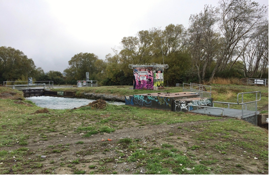 Photo 1: Intake gate, control building and fish screen
| 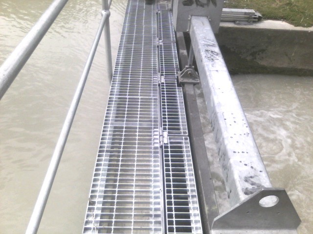 Photo 2:
Control Gate
|
 Photo 3: Inlet Weir
|  Photo 4: Sediment Pond 1
|
 Photo 5: Sediment Pond 2
|
3.11 Risk Assessment
A risk assessment has been undertaken for the Paparua scheme. The key output from the risk assessment is the identification of any extreme and high risks which need to mitigated. In order to mitigate these risks they have been included and budgeted for in the projects within this LTP. Table 3‑6 details the risk priority rating and Table 3‑7 outlines the risks for this scheme.
Table 3‑6 Risk Priority Rating
| > 50 | Extreme | Awareness of the event to be reported to Council. Urgent action to eliminate / mitigate / manage the risk. Document risk and action in the AMP. |
| 35-50 | Very High | Risk to be eliminated / mitigated / managed through normal business planning processes with responsibility assigned. |
| 14-35 | High | Manage risk using routine procedures. |
| 3.5-14 | Moderate | Monitor the risk. |
| < 3.5 | Low | Awareness of the event to be reported to Council. Immediate action required to eliminate / mitigate / manage the risk. Document risk and action in the AMP. |
Table 3‑7 Risks – Paparua
| Collapse of old tunnels Kowai | Condition inspection of water race tunnels | 2014 | 10 | 3.5 | 3.5 |
| Public Health and Safety risks at intakes | Health and Safety improvements | 2014 | 10 | 10 | 10 |
| Sink holes are developing | Develop standard soak hole repair procedures | 2014 | 9 | 9 | 9 |
| Siphons are a risk | Condition inspection of water race siphons | 2014 | 12 | 12 | 10 |
| Public Health and Safety risks at intakes | Health and Safety improvements | 2014 | 10 | 10 | 7 |
| Siphons are a risk | Condition inspection of water race siphons | 2014 | 12 | 12 | 10 |
| Non-consented activities | Renewal of consents | 2014 | 27 | 27 | 6 |
| Collapse of old tunnels Waimak | Tunnel repairs | 2017 | | 20 | 10 |
The list of district wide risks can be found in 5Waters Activity Management Plan: Volume 1.
3.12 Asset Valuation Details
The total replacement value of assets within the Paparua Scheme is $23,140,131 with further details in Table 3‑8 below.
Table 3‑8 Replacement Value, Paparua
Plant and Equipment
| $67,808
|
Water Race Reticulation
| Channel | $21,196,384
|
| Divide | $643,598
|
| Gate | $56,744
|
| Inlet-Outlet-Point | $1,113,713
|
| Instruments | $12,360
|
| Structure | $49,525
|
Channels are broken down into open channels: culverts, lateral, locals, mains, siphons and culverts. Main races are have a larger cross sectional area in comparison to locals and laterals.
3.13 Renewals
The renewal profile has been taken from the 2019 5 Waters Valuation. A graph showing the renewals for this scheme are shown by Figure 3‑6 below. The majority of assets requiring renewal are culverts which occur in the period 2019-2023.
The open race channels are taken as having infinite lives (renewal by maintenance) and therefore renewals are not budgeted for these assets types.
Figure 3‑6 Paparua Water Race Renewal Profile
There are many aging structures within the water race network these include gates, intake structures, tunnels, siphons, aqueducts and culverts. These assets are near the end of their life and will require increased funding moving into the future.
314 Critical Assets
The criticality model for Paparua has been updated for the 2021 AcMP. The methodology of the criticality model can be found in 5Waters Activity Management Plan: Volume 1 and it provides details of how the criticality has been calculated for the reticulation assets. Table 3‑9 and Figure 3‑7 below show the level of criticality for all of the assets within this scheme that have a recorded known length.
Table 3‑9 Length of Assets per Criticality Level
5
| Low | 323,496
|
4
| Medium-Low | 101,760
|
3
| Medium | 5,645 |
2
| Medium-High | 11 |
1
| High | 49
|
3.15 Asset Condition
The asset condition model was run for Paparua in 2021. The methodology of the model can be found in 5Waters Activity Management Plan: Volume 1 and it provides details of how the model has been calculated for the reticulation assets (particularly pipes). Figure 3‑8 below shows the level of asset condition for all of the assets within this scheme that have a recorded known condition.
Table 3‑10 provides a description of the condition rating used within the condition model.
Table 3‑10 Asset Condition Grading
| 1.0 | Excellent |
| 2.0 | Good |
| 3.0 | Moderate |
| 4.0 | Poor |
| 5.0+ | Fail |
3.16 Funding Program
The 10 year budgets are shown by Table 3‑11. Budgets are split into expenditure, renewals, projects and capital projects. Expenditure and renewals have been reported on a district-wide basis in Volume 1.
All figures are ($) not adjusted for CPI “inflation". They are calculated on historical data, and population growth where relevant.
Table 3‑11 Budget Summary
| 2021/2022 | -
| -
|
2022/2023
| -
| -
|
| 2023/2024 | -
| -
|
| 2024/2025 | -
| $40,000
|
| 2025/2026 | -
| $200,000
|
| 2026/2027 | -
| $200,000
|
| 2027/2028 | -
| - |
2028/2029
| -
| -
|
2029/2030
| -
| -
|
2031/2032
| -
| -
|
| Total | -
| $440,000
|
An explanation of the categories within the budgets are as follows below:
-
Expenditure consists of operation and maintenance costs;
-
Renewals are replacement of assets which are nearing or exceeded their useful life;
-
Projects are investigations, decisions and planning activities which exclude capital works; and
-
Capital projects are activities involving physical works.
Table 3‑12 Key Projects
Capital Projects
| -
| Bells Divide upgrade
| -
| -
| -
| $440,000
| 100% LoS
|
* Where LoS refers to Level of Service and G refers to Growth
The list of district wide projects can be found in 5Waters Activity Management Plan: Volume 1.
Discussion on Projects
Projects have been determined based on their:
- Relevance to the scheme
- Requirement to be completed under legislation
- Ability to bring the scheme up to or maintain the Level of Service required under council's Asset Management Policy.
Many projects are jointly funded by more than one scheme and activity. Each scheme pays a pro-rata share only, equivalent to the number of connections.
Discussion on Capital and Projects
Where relevant, Capital (Levels of Service) and Capital (Growth) projects have been included in the scheme financial details.
Levels of Service Projects and growth splits have been provided to ensure the costs of population driven works are clear.
<<
5-Water-Volume-6-Water-Races