<<
5-Waters-Volume-4-Stormwater
11 Leeston Stormwater Scheme
11.1 Scheme Summary
Scheme Area
| 257.19ha |
| Scheme Coverage (as at 1 Jan 2021) | Rating numbers | 929
|
System components
| Piped (m) | 15,990
|
| Swales (m) | 2,950
|
| Drains (m) | 4,266
|
| Manholes/Inspection Chambers (No.) | 106
|
| Treatment | 3 proprietary devices
1 Wetland
3 basins
|
| Other | N/A |
Value ($)
| Replacement Cost | $6,692,351
|
| Depreciated Replacement Cost | $5,128,621
|
Financial
| Operator cost (scheduled and reactive maintenance) per connection
| $19.23/connection
|
Planning
| Stormwater Management Plan | Draft |
| No. SDC stormwater consents | 6
|
Demand
| Mean Annual Rainfall (mm) | 628
|
| 10% AEP (10 year) 1hr rainfall depth (mm) | 19.2 |
| Sustainability | Sustainable drain management practices | Adopted and Encouraged |
11.2 Key Issues
The following key issues are associated with the Leeston Stormwater Scheme. A list of district wide issues are located in 5Waters Activity Management Plan: Volume 1.
Table 11‑1 Leeston Scheme Issues
| Township flooding from upper catchment draining into Leeston Creek. | Continue to consult with the Community regarding options including the Leeston North Stormwater Bypass. |
| Township flooding from local run off | Discuss township modelling with the Community to identify reticulation upgrades required to reduce localised ponding during rainfall events. |
11.3 Overview & History
The Leeston stormwater system is predominantly a piped network with some swales and open drains. The discharge of this network is mainly to the Leeston Creek, with parts of the catchment discharging to other land drainage systems. Leeston Creek is spring feed and flows on to Te Waihora (Lake Ellesmere), 6 kilometres south-east of Leeston.
A Stormwater Management Plan 'Leeston Stormwater Management Plan, January 2006' has been prepared for the proposed subdivision located to the north of Leeston adjacent to Manses Road.
Over the 15-17 and 19-22 June 2013, 254 mm property flooding of rainfall fell resulting in significant surface flooding of a number of properties. In Leeston town originating from a number of classified drains including Leeston Creek. Sand bagging was undertaken by the volunteer fire service.
Following the flooding a community meeting and drop in session was in July 2013 and 9 options proposed by Council to the community committee in November 2013. These options included the Leeston North Bypass (including upgrade of the showground culverts) and extension and upgrade of drain 40 on Harmans Road, additional piping in the township and township modelling. These options will be further investigated and community consultation undertaken in 2014.
A level transducer has been installed in Leeston Creek linked to SCADA. The transducer is located on the culvert of the corner of Gallipoli and Selwyn Street.
The community agreed to fund the bypass works as part of the 2015-25LTP consultation process. The first stage of the bypass is complete.
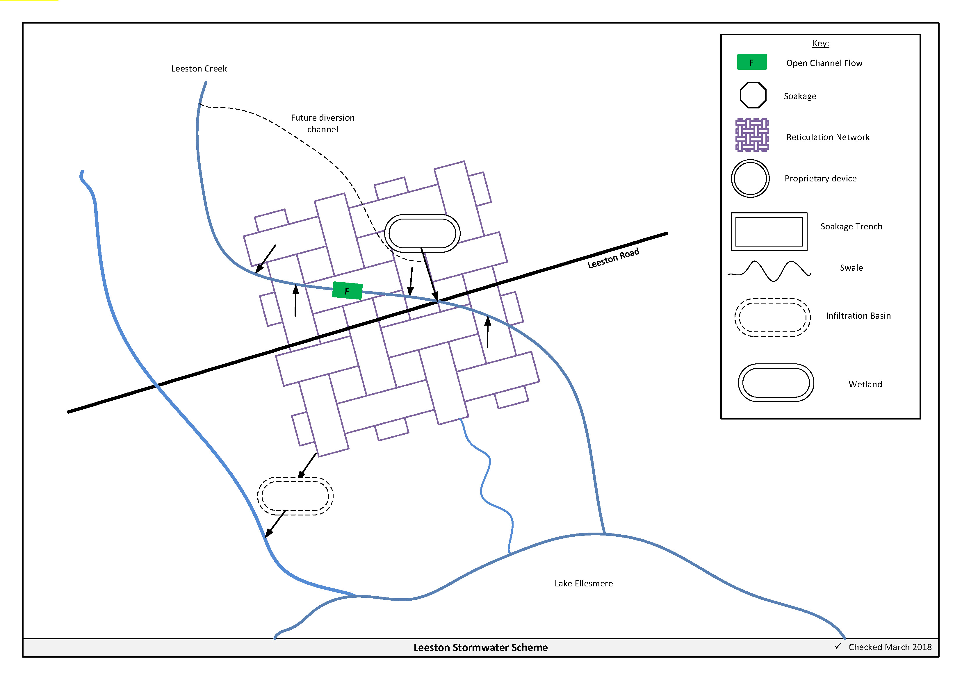
Figure 11‑2 Scheme Schematic
11.4 Resource Consents
The Leeston stormwater scheme has a number of resource consents. Table 11‑2 shows the stormwater discharge permitted by the resource consents for this scheme.
Consent, CRC930163, is to divert Leeston creek to Tramway reserve road (July 2029). This is linked to CRC930165.1 which is the consent used when groundwater is too high to irrigate sewage at Ellesmere treatment plant and to divert water for Doyleston when required to Tramway Reserve.
Table 11‑2 Resource Consents
CRC143914*
Issued - Active | To change conditions 3, 4, 5 and 6 of CRC071838.2 - to discharge contaminants into surface water | Pound Road Leeston, Dunsandel Road & Manses Road, LEESTON | 22/01/2014 | 24/08/2042 |
CRC930163
Issued - Active | To dam Leeston Creek by means of an existing concrete structure and to divert flow to Tramway Reserve Drain. | Leeston And Springston Roads, LEESTON
| 29/08/1995 | 28/07/2029 |
CRC186175
| To discharge stormwater to surface water from the existing stormwater network of Leeston
| Leeston
| TBC (Application Underway)
| TBC
|
Resource Consents for the Bypass:
CRC072300
Issued - Active | To excavate soil from over a confined aquifer for the creation of a new channel and wetland at or about map reference. | Pound Road Leeston, Dunsandel Road & Manses Road, LEESTON | 11/09/2007
| 24/08/2042 |
CRC071840
Issued - Active | To undertake works in a watercourse to establish the overflow for the flood overflow channel in Leeston Creek as part of a proposed residential subdivision comprising of approximately 330 lots on land which has been rezoned Living 2 and Living LXA under the Selwyn District Plan | Pound Road Leeston, Dunsandel Road & Manses Road, LEESTON | 11/09/2007 | 24/08/2042 |
CRC071839
Issued - Active | To divert a watercourse, being the flood overflow channel of Leeston Creek as part of a proposed residential subdivision comprising of approximately 330 lots on land which has been rezoned Living 2 and Living LXA under the Selwyn District Plan | Pound Road Leeston, Dunsandel Road & Manses Road, LEESTON
| 11/09/2007 | 24/08/2042 |
New subdivisions at 28 Manse Road (CRC136091) and Corner of Manse Road and High Streets discharge (CRC136819 and CRC131889) to open drain as a permitted activity.
*Note this consent requires installation of roof water infiltration tanks. A consent variation was submitted to remove this condition in 2013, awaiting decision. This consent also includes a requirement to upgrade the capacity of Leeston Creek.
11.5 Integrated Stormwater Management Plan
Environment Canterbury's Land and Water Regional Plan became operative on the 13th December 2018. Under policy 4.16, any reticulated stormwater system for an urban area requires a stormwater management plan. Additionally, from 1 January 2025, operators of reticulated stormwater systems will become responsible for the quality and quantity of all stormwater discharged from the reticulated stormwater system. The Leeston stormwater management plan was updated in April 2017 and submitted to ECan.
11.6 Scheme Assets
Council has a wide variety of stormwater assets within the district. A brief description of the assets within this scheme is provided below:
a. Humeceptor - Is a hydrodynamic separator which helps to reduce mass sediment load from the discharge, some removal of hydrocarbons is also achieved.
b. Swale (Grassed) – Is a longitudinal open channel which is lined with grass. The swale both conveys and treats stormwater.
c. Infiltration basin – is a stormwater management device which is used to store, treat and dispose of stormwater to the ground via soakage.
d. Wetland - is a stormwater management device which is used to attenuate, treat and dispose of stormwater. Discharge from a wetland is to surface water (open drains or streams). Wetlands have high biodiversity value and are best suited in areas where the ground water table is high.
e. Open drains – are channels used to convey stormwater. They are cost effective means to convey large volumes of water.
f. Flood diversion channel – is a large scale open drain designed to convey flood flows.
A summary of material and diameter for channels and pipes, where known, is shown below in Figure 11‑3 and Figure 11‑4.
Figure 11‑3 Pipe Material - Leeston
Figure 11‑4 Pipe Diameter – Leeston
11.7 Operational Management
The stormwater network is operated and maintained under two maintenance contracts as follows:
- Contract 1241: Water Services Contract. Contract is with SICON who undertakes investigations, conditions inspections, proactive and reactive maintenance and minor asset renewals.
- Contract 1202: Parks and Reserves Contract. Contract is with SICON who undertakes the maintenance of land scape features related to water services e.g. mowing, gardens etc.
Water quality sampling is completed under an agreement with Food and Health Ltd as required.
11.8 Photos of Main Assets
The photos below provide a summary of the types of assets found within this stormwater management area.
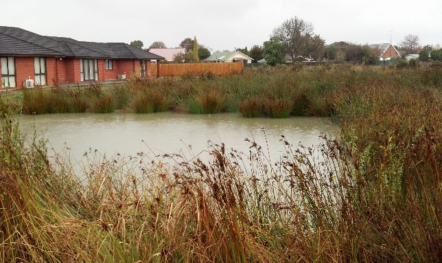
Photo 1 & 2 – Leeston North Wetland
|
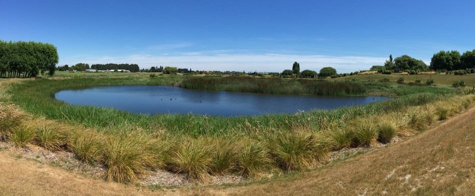
Photo 1 & 2 – Leeston North Wetland
|
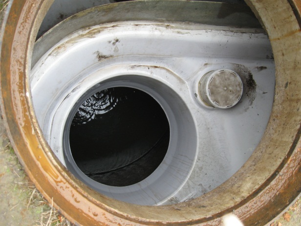
Photo 3 – Humeceptor
| 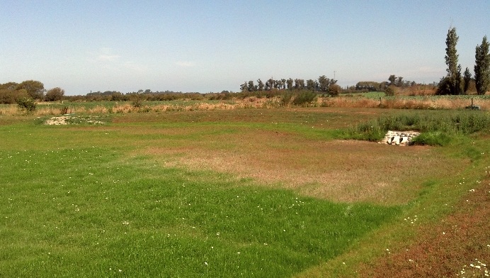
Photo 4 - Millbridge
|
11.9 Rapid Flood Modelling
The Council has undertaken 'Rapid Flood Hazard Assessment' modelling for its main townships. The modelling uses DHI MIKE 21 to simulate rainfall on grid with the outputs processed through ArcGIS producing maps illustrating a range of flood deeps during different rainfall intensities and durations.
The rapid flood assessment has been generated to provide a high level summary of potential flood and ponding areas across the district during extreme rainfall events. The results from this study are not to be used to set floor levels. The results have not been ground tested and therefore are indicative only.
For a 50 year event, Figure 11‑5 shows the predicted flooding for Leeston.

Figure 11‑5 Rapid Flood Modelling, Leeston
11.10 Risk Assessment
A risk assessment has been undertaken for the Leeston scheme. The key output from the risk assessment is the identification of any extreme and high risks which need to be mitigated. In order to mitigate these risks they have been included and budgeted for in the projects within this LTP. Table 11‑3 details the risk priority rating and Table 11‑4 outlines the risks and the list of key projects is found in Table 11‑9.
Table 11‑3 Risk Priority Rating
> 50
| Extreme | Awareness of the event to be reported to Council. Urgent action to eliminate / mitigate / manage the risk. Document risk and action in the AMP. |
| 35-50 | Very High | Risk to be eliminated / mitigated / managed through normal business planning processes with responsibility assigned. |
| 14-35 | High | Manage risk using routine procedures. |
| 3.5-14 | Moderate | Monitor the risk. |
| < 3.5 | Low | Awareness of the event to be reported to Council. Immediate action required to eliminate / mitigate / manage the risk. Document risk and action in the AMP. |
Table 11‑4 Risks - Leeston
| Flooding | Show ground culvert upgrade, Manse Road upgrade | 2014 | 20 | 20 | 20 |
| Lack of asset data | Collect asset data | 2014 | 9 | 2 | 2 |
| Non-consented activities | Renewal of consents | 2014 | 27 | 27 | 6 |
The list of district wide risks can be found in 5Waters Activity Management Plan: Volume 1.
11.11 Asset Valuation Details
The total replacement value of assets within the Leeston Scheme is $6,692,351 as detailed in Table 11‑5 below.
Table 11‑5 Replacement Value, Leeston
Stormwater Reticulation
| Chamber | $90,775
|
| Channel | $320,054
|
| Inlet-Outlet-Point | $132,179
|
| Lateral | $639,162
|
| Management Device | $343,308
|
| Manhole | $671,728
|
| Pipe | $4,476,806
|
| Valve | $18,339
|
11.12 Renewals
The renewal profile has been taken from the 2019 5 Waters Valuation. A graph showing the renewals for this scheme is shown by Figure 11-6 below. The majority of assets requiring renewal are culverts/pipes which occur in the year 2040/41.
Figure 11‑6 Leeston Stormwater Renewal Profile
11.13 Critical Assets
The criticality model for Leeston has been updated for the 2021 AcMP. The methodology of the criticality model can be found in 5Waters Activity Management Plan: Volume 1 and it provides details of how the criticality has been calculated for the reticulation assets. Table 11‑6 and Figure 11‑7 below show the calculated criticality for all of the assets within this scheme that have a recorded known length.
Table 11‑6 Length of Assets per Criticality Level
5
| Low | 15,466
|
4
| Medium-Low | 614
|
3
| Medium | 1,853
|
2
| Medium-High | 649
|
1
| High | 135
|
11.14 Asset Condition
The asset condition model was run for Leeston in 2021. The methodology of the model can be found in 5Waters Activity Management Plan: Volume 1 and it provides details of how the model has been calculated for the reticulation assets (particularly pipes). Figure 11‑8 below shows the level of asset condition for all of the assets within this scheme that have a recorded known condition.
Table 11‑7 provides a description of the condition rating used within the condition model.
Table 11‑7 Asset Condition Grading
| 1.0 | Excellent |
| 2.0 | Good |
| 3.0 | Moderate |
| 4.0 | Poor |
| 5.0+ | Fail |
11.15 Funding Program
The 10 year budgets are shown by Table 11‑8. Budgets are split into expenditure, renewals, projects and capital projects. Expenditure and renewals have been reported on a district-wide basis in Volume 1.
All figures are ($) not adjusted for CPI “inflation". They are calculated on historical data, and population growth where relevant.
Table 11‑8 Budget Summary
| 2021/2022 | $5,000
| $900,000
|
2022/2023
| -
| $30,000
|
| 2023/2024 | -
| $20,000
|
| 2024/2025 | -
| $100,000
|
| 2025/2026 | -
| $600,000
|
| 2026/2027 | -
| -
|
| 2027/2028 | -
| - |
2028/2029
| -
| -
|
2029/2030
| -
| -
|
2031/2032
| -
| -
|
| Total | $5,000
| $1,650,000
|
An explanation of the categories within the budgets are as follows below:
-
Expenditure consists of operation and maintenance costs;
-
Renewals are replacement of assets which are nearing or exceeded their useful life;
-
Projects are investigations, decisions and planning activities which exclude capital works; and
-
Capital projects are activities involving physical works.
Table 11‑9 Key Projects
Capital Projects
| -
| Leeston bypass
| $900,000
| -
| -
| $600,000
| TBC
|
Capital Projects
| -
| Upgrading of flood gate including add SCADA site
| -
| $20,000
| -
| -
| TBC
|
Capital Projects
| -
| SCADA drain level Cunningham site
| -
| -
| $20,000
| -
| TBC
|
Capital Projects
| -
| Groundwater issue at Clausen Avenue basin
| | $10,000
|
| $100,000
| TBC
|
* Where LoS refers to Level of Service and G refers to Growth
The list of district wide projects can be found in 5Waters Activity Management Plan: Volume 1.
Discussion on Projects
Projects have been determined based on their:
- Relevance to the scheme
- Requirement to be completed under legislation
- Ability to bring the scheme up to or maintain the Level of Service required under council's Asset Management Policy.
Many projects are jointly funded by more than one scheme and activity. Each scheme pays a pro-rata share only, equivalent to the number of connections.
Discussion on Capital and Projects
Where relevant, Capital (Levels of Service) and Capital (Growth) projects have been included in the scheme financial details.
Levels of Service Projects and growth splits have been provided to ensure the costs of population driven works are clear.
<<
5-Waters-Volume-4-Stormwater