<<
5-Water-Volume-6-Water-Races
1 Ellesmere Water Races
1.1 Scheme Summary
| Scheme area (within scheme boundary) | 50,158 ha |
Scheme Coverage (1 Jan 2021)
| Area of Full Charges | |
| Minimum Charges (No.) | 113 |
| Irrigators | 7 |
Systems components
| Intakes | 2 (Grasslands & Lower Rakaia) |
| Main Race | 159.24 km |
| Local Race | 92.34 km |
| Lateral Race | 83.06 km |
| Other | 4 flow gauging sites + 1 Flow level site |
| Water Source | via River | Rakaia River (Glenroy, Lower Rakaia) |
| History | Installation Date | Installed progressively from 1880 |
Value ($)
| Replacement Cost | $18,499,046
|
| Depreciated Replacement Cost | $17,338,616
|
Financial
| Annual maintenance cost % of total water race scheme maintenance
| $478,743/year
23% of total water race maintenance spend
|
Water Take
| Annual average (from Management Plan) | 62.6 million m3 |
| Consented Take | 3,290 Lts/sec |
Sustainability
| Biodiversity | Groundwater recharge and natural habitat |
| Amenity | Urban feature |
1.2 Key Issues
The following key issues are associated with the Ellesmere Water Race system. A list of district wide issues are located in 5Waters Activity Management Plan: Volume 1.
Table 1‑1 Ellesmere Scheme Issues
| Impacts of CPW on the future of the water race scheme. | CPW stage 1, which traverses the northern extent of the Ellesmere water race scheme, is now complete. The number of requests for race closures has greatly increased. Council needs to carefully balance the request for race closures with the ecological and environmental benerfits of keeping the races open. |
| Operating water race for biodiversity values will add financial pressure. | An alternative rating structure is proposed which takes into account benefits of the race network other than stock water. The alternative rating structure is one of the matters included in the 2018-28 consultation document. |
| Due to fluctuating river levels, resource consent conditions are not always met with manually operated intake gates. | Council will consider opportunities to budget for automation of the intakes where cost effective to improve consent compliance and reduce operational costs. Automated gates are currently installed on the Paparua and Upper Kowai intakes. |
| Effective management of stock water and separately consented irrigation water which is conveyed through the Council stockwater network | Irrigation agreements to be reviewed and updated. |
1.3 Overview & History
The Ellesmere scheme serves the plains area between the Rakaia and Hororata Rivers from Te Pirita and Haldon in the northwest to Rakaia Huts and Southbridge in the southeast.
The source of water for the Ellesmere Water Race is the Rakaia River.
From the Grasslands intake (at Rakaia River) the main race traverses the main Rakaia Terrace in a sliding cut to gain access to the central plains area near the top end of Sharlands Road about 4kms east of Te Pirita Road. From this point the main race divides into two races, the main flow follows Sharlands Road down to the S.H.1. Main Highway. It has a number of laterals leading off it distributing water across the plain. Below the Main Highway it eventually joins into the upper half the Lower Rakaia intake race system.
The other race known as the Cross Race heads across the plain on a very flat grade, generally following the contour towards the Hororata River. This cross race has lateral races leading down the plains. It is also used to transport a flow of 80 to 100l/second from Grasslands Intake main race from the vicinity of Sharlands Road to the Haldon scheme race system at Mitchells Road. The Haldon intake and downstream races were closed during the 2015/16 year following public consultation and approval by Council.
Natural events impacting the water race network
Some damage to the scheme channels occurred following the September 2010 earthquakes. A significant amount of inspection occurred, with simple realignment work completed as required.
Significant damage occurred to the water races as a result of the wind event in September 2013. Repairs were carried out as a result of uprooted trees.

Figure 1‑2 Scheme Schematic
1.4 Resource Consents
The Ellesmere water race scheme has a number of resource consents. Table 1‑2 shows the water takes permitted by the resource consents at the three intakes and Table 1‑3 details the resource consents for this scheme.
Table 1‑2 Allowable Take
| Early's – Stock | 732 | 732 |
| Early's – Irrigation | 1751 | 1751 |
| Haldon (Hororata River) | 341 | 500 |
| Main South Rd (Lower Rakia) | 466 | 500 |
|
Total | 3,290 | 3,483 |
Table 1‑3 Resource Consents
| CRC011996 | To take from Rakaia River at Headworks Road and Hororata River. | Stockwater Race Network | 21/11/2011 | 21/11/2031 | Issued – Active |
| CRC970986 | To divert water from the Rakaia River. | Steeles Road, Te Pirita | 21/11/2011 | 21/11/2031 | Issued – Active |
| CRC153238 | To divert, take and use water at Earlys Intake. | Steeles Road, Te Pirita | 21/11/2013 | 21/11/2031 | Issued – Active |
CRC201738
| Global Consent - To discharge contaminants into water and onto land in circumstances where they may enter surface water. | Global Consent (Spraying) | 25/01/2021
| 25/01/2036
| Issued – Active
|
CRC212849
| Global Consent - To discharge contaminants to air
| Gloabal Consent (Spraying)
| 25/01/2021
| 25/01/2036
| Issued - Active
|
| CRC012001 | To discharge into the Hororata River from overflow and general discharge. | Stockwater Race Network | 21/11/2011 | 21/11/2031 | Issued – Active |
| CRC010976 | To discharge unused water from race into the Rakaia River. | Steeles Road, Te Pirita | 21/11/2011 | 21/11/2031 | Issued – Active |
| CRC011993 | To disturb the bed of the Hororata River. | Stockwater Race Network | 21/11/2011 | 21/11/2031 | Issued – Active |
| CRC972765 | To discharge water to the Rakaia River. | Steeles Road, Te Pirita | 21/11/2011 | 21/11/2031 | Issued – Active |
| CRC72766 | To disturb the bed of the Rakaia River at Early's intake for the purpose of supplying stockwater. | Steeles Road, Te Pirita | 12/12/1997 | 10/12/2032 | Issued – Active |
In November 2011 a variation to the Rakaia River Water Conservation Order was made by Trust Power Ltd. Council staff had a number of concerns which they were submitted. An agreement was signed dated 11 July 2012 between the Council and TrustPower which stated:
“TrustPower will not, through the Coleridge Project, adversely affect the existing assets held and operated by the Council for the purposes of taking and conveying water from the Rakaia River for the purposes of stock water".
1.5 Scheme Assets
1.5.1 Intakes
Grasslands Intake - Grasslands Intake, formally referred to as Earlys Intake, consists of a temporary dozed channel in the river bed leading to a protected side channel of about 3 to 4 kilometres in length along the northern river bank to Grasslands intake structure where water is diverted into the scheme. Water can be diverted into this channel at several points depending on where the main river channel is situated after flooding in river. Best practice is generally to have two small diversions rather than one large diversion into the channel.
The irrigation race divide is located about 10 kilometres below this intake. At this point control gates are used to split the flow depending on scheme demand.
Lower Rakaia Intake - This intake is sited on the Rakaia River about 3kms downstream of the SH1 Rakaia Bridge. Road access to the intake gates is off the Main Rakaia Road onto Headworks Road. The intake consists of two concrete box structures and the control gates are sited at the end of this road on the northern bank of the Rakaia River.
1.5.2 Silt Ponds
Silt ponds are located at the Glenroy intake ponds.
1.5.3 Control Structures
Major divides are on the main races below the main intake control gates. The divides are a mixture of newer metal gates and boulder control gates sited where the main race flow requires splitting into equal or different flows. Each split race then goes in to serve a different part of the scheme. The weirs are required to be set to enable the correct amount of water to be diverted to serve the area required.
1.5.4 Monitoring Points
Monitoring structures are sited below intakes to measure the quantity of water taken from the source to enable the operator to have an understanding of what flows are present, confirm compliance with resource consents, record water take and monitor scheme demand.
The monitoring structures on the Ellesmere Water Race System are at Grasslands Intake downstream of the fish screen, the Lower Rakaia Intake, 40 metres downstream of the intake gate.
Council also has three other 'in race' monitoring stations to better manage flows, refer to Figure 1‑2 for monitoring locations.
Installation of SCADA has occurred at the Grasslands Intake but not at the Lower Rakaia site. Flow gauging is ongoing at these sites.
1.5.5 Emergency Discharge Points
Emergency discharge points are located at the Early's Intake on the Terrace Lea propertyThere are no emergency discharge points within the race system.
1.5.6 Soak Holes
Soak holes allow excess water taken from the intake, to meet additional usage to be discharged without flooding properties when demand reduces. Maximum flow to each soak hole is 10 L/sec. The Ellesmere scheme has 37 soak holes (including privately owned).
1.5.7 Pipe Summary
A summary of material and diameter for pipes and aquaducts, where known, is shown below in Figure 1‑3 and Figure 1‑4.
Figure 1‑3 Pipe Material – Ellesmere
Figure 1‑4 Pipe Diameter – Ellesmere
1.6 Operational Management
The scheme is operated in two sections, the first being from Early's intake to just below the Main South Road, and the Lower Rakaia Intake servicing just below Main South Road.
Personnel from Canterbury Grasslands monitor and manage the Glenroy Scheme to ensure allocated water is available to the Council Scheme.
The Council's nominated Contractor carries out an inspection of main divides and race flows.
From the above inspection the Council nominated Contractor can ascertain which races require additional or less water. Adjustments can then be made to major divides as required.
The lower section requires inspection of the main intake at Headworks Road, the river and cleaning of the intake grill and adjusting flows as required followed by checking main divides and races. It also involves discussing and adjusting flows into the lower area with the Upper Rakaia Intake Operator.
1.7 Irrigation
There are seven irrigators which hold their own consents and take from the upper part of the Ellesmere scheme. The Lower Rakaia Diversion group also take water from on the lower part of the Ellesmere Scheme. Irrigation agreements are required with each user. The agreement covers individual water allocations and monitoring responsibilities.
In 2015 Council established new irrigation agreements with the Ellesmere irrigators. As part of this agreement Council agreed to clear the irrigation return to the river on an ongoing basis.
In 2014 Council met with representatives of the Lower Rakaia Diversion group. Council are charged a share of the costs of the Lower Rakaia Diversion group based on their share of the total take. This is invoiced to Council.
1.8 Environmental Management
1.8.1 Water Quality Issues
Water quality in races can be affected by runoff and stock activity in races. Runoff containing fertiliser and organic nutrients is difficult to manage. Stock activity (especially cattle, horses and deer) can affect water quality by increasing sedimentation from bank erosion and disturbance of the bottom of the race channel. Direct defecation and surface runoff can also add to elevated faecal coliform levels.
Improved management of the water race network will need to address stock movement in races. Maintenance contractors and users need to be aware of the effect of operation and maintenance activities on water race quality.
1.8.2 Management Approach
The Council will use a combination of the following to address water quality issues:
- Watering bays are being promoted for water races that serve all stock farming properties (excluding sheep). This will allow limited and controlled access to races for stock drinking purposes. The remaining length of races to be fenced off/hot wired so that animals only have access to the race for drinking purposes. This is 'best practice' for managing stock access to races.
- The Council will provide guidance to race users on design/layout of watering bays
- Maintenance contractors will ensure that subcontractors use clean and sound machinery when working in riverbeds.
- Maintenance Contractors will be required to monitor and minimise discharge of surplus water from the race network
1.8.3 Demand Management
Environment Canterbury as the consenting authority are requiring demand management practices to be implemented as part of new or reviewed consent conditions. This is due to water allocations in most areas of the district being assumed as fully committed.
Selwyn District Council has addressed demand management within its Water Race Management Plan.
An efficiency audit has not been undertaken for the Ellesmere scheme.
1.9 Photos of Main Assets
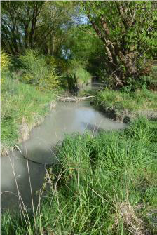
Photo 1: Lower Rakaia Intake Channel
| 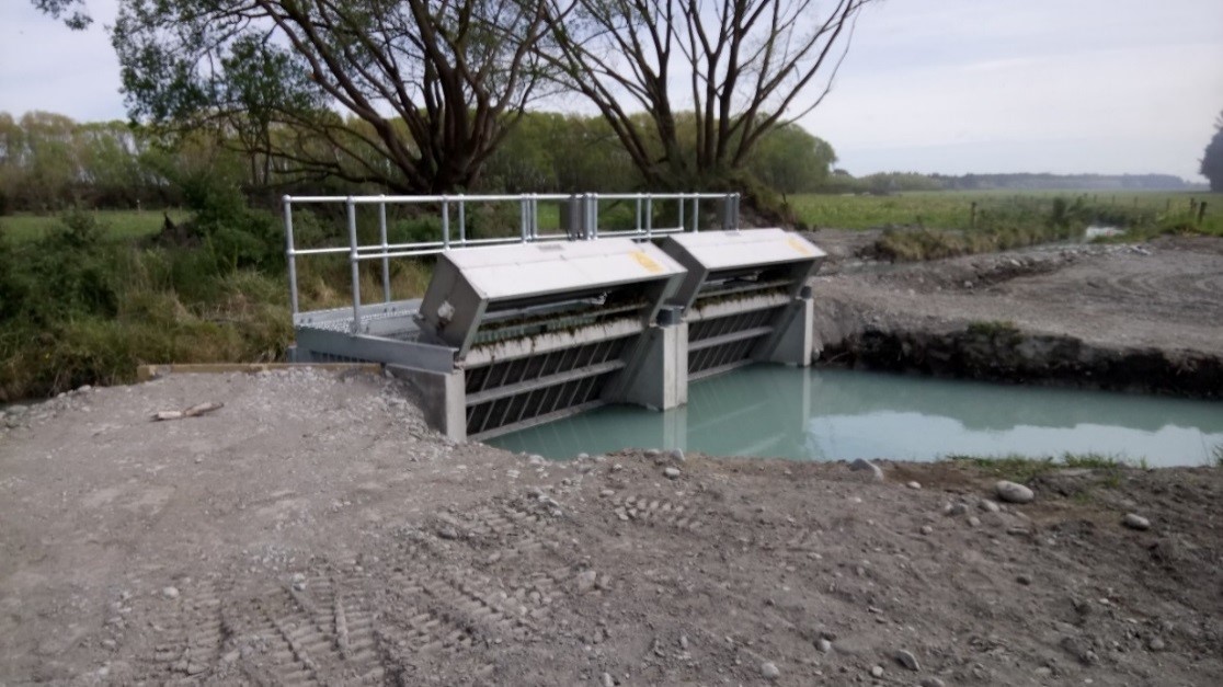
Photo 2: Lower Rakaia fish screen
|
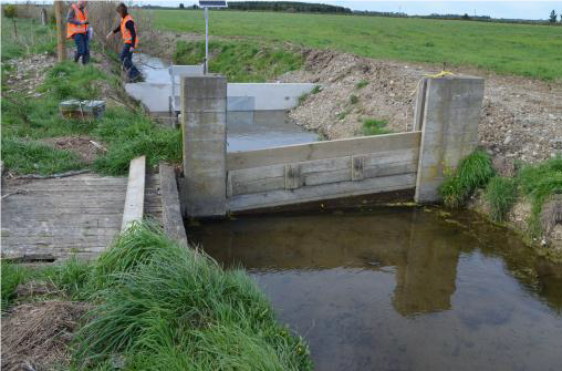
Photo 3: Typical flow gauging site
|
1.10 Risk Assessment
A risk assessment has been undertaken for the Ellesmere scheme. The key output from the risk assessment is the identification of any extreme and high risks which need to be mitigated. In order to mitigate these risks they have been included and budgeted for in the projects within this LTP. Table 1‑4 Risk Priority Rating details the risk priority rating and Table 1‑5 outlines the risks for this scheme.
Table 1‑4 Risk Priority Rating
| > 50 | Extreme | Awareness of the event to be reported to Council. Urgent action to eliminate / mitigate / manage the risk. Document risk and action in the AMP. |
| 35-50 | Very High | Risk to be eliminated / mitigated / managed through normal business planning processes with responsibility assigned. |
| 14-35 | High | Manage risk using routine procedures. |
| 3.5-14 | Moderate | Monitor the risk. |
| < 3.5 | Low | Awareness of the event to be reported to Council. Immediate action required to eliminate / mitigate / manage the risk. Document risk and action in the AMP. |
Table 1‑5 Risks - Ellesmere
| Public Health and Safety risks at intakes - lower rakaia | Health and Safety improvements | 2014 | 10 | 10 | 10 |
| Non-consented activities | Renewal of consents | 2014 | 27 | 27 | 6 |
The list of district wide risks can be found in 5Waters Activity Management Plan: Volume 1.
1.11 Asset Valuation Details
The total replacement value of assets within the Ellesmere Scheme is $18,499,046 with further details in Table 1‑6 below.
Table 1‑6 Replacement Value, Ellesmere
Plant and Equipment
| $41,412
|
Water Race Reticulation
| Channel | $18,137,676
|
| Divide | $77,232
|
| Gate | $18,513
|
| Inlet-Outlet-Point | $94,011
|
| Structure | $130,203
|
Channels are broken down into Culverts, Lateral, Locals and Mains. Main races have a larger cross sectional area in comparison to locals and laterals.
1.12 Renewals
The renewal profile has been taken from the 2019 5 Waters Valuation. A graph showing the renewals for this scheme are shown by Figure 1‑5 below.
The open race channels are taken as having infinite lives (renewal by maintenance) and therefore renewals are not budgeted for these assets types.
Figure 1‑5 Ellesmere Water Race Renewal Profile
There are many aging structures within the water race network these include gates, intake structures, and culverts. These assets are near the end of their life and will require increased funding moving into the future.
1.13 Critical Assets
The criticality model for Ellesmere has been updated for the 2021 AcMP. The methodology of the criticality model can be found in 5Waters Activity Management Plan: Volume 1 and it provides details of how the criticality has been calculated for the reticulation assets. Table 1‑7 and Figure 1‑6 below show the calculated criticality for all of the assets within this scheme that have a recorded known length.
Table 1‑7 Length of Assets per Criticality Level
5
| Low | 174,528
|
4
| Medium-Low | 151,065
|
3
| Medium | 3,938 |
2
| Medium-High | 2,550 |
1
| High | 0
|
1.14 Asset Condition
The asset condition model was run for Ellesmere in 2021. The methodology of the model can be found in 5Waters Activity Management Plan: Volume 1 and it provides details of how the model has been calculated for the reticulation assets (particularly pipes). Figure 1‑7 below shows the level of asset condition for all of the assets within this scheme that have a recorded known condition.
Table 1‑8 provides a description of the condition rating used within the condition model.
Table 1‑8 Asset Condition Grading
| 1.0 | Excellent |
| 2.0 | Good |
| 3.0 | Moderate |
| 4.0 | Poor |
| 5.0+ | Fail |
1.15 Funding Program
The 10 year budgets are shown by Table 1‑9. Budgets are split into expenditure, renewals, projects and capital projects. Expenditure and renewals have been reported on a district-wide basis in Volume 1.
All figures are ($) not adjusted for CPI “inflation". They are calculated on historical data, and population growth where relevant.
Table 1‑9 Budget Summary
| 2021/2022 | -
| -
|
2022/2023
| -
| $50,000
|
| 2023/2024 | -
| -
|
| 2024/2025 | -
| -
|
| 2025/2026 | -
| -
|
| 2026/2027 | -
| -
|
| 2027/2028 | -
| - |
2028/2029
| -
| -
|
2029/2030
| -
| -
|
2031/2032
| -
| -
|
| Total | -
| $50,000
|
An explanation of the categories within the budgets are as follows below:
-
Expenditure consists of operation and maintenance costs;
-
Renewals are replacement of assets which are nearing or exceeded their useful life;
-
Projects are investigations, decisions and planning activities which exclude capital works; and
-
Capital projects are activities involving physical works.
Table 1‑10 Key Projects
Capital Projects
| -
| Two culvert upgrades in Lower Ellesmere
| -
| $50,000
| -
| -
| -
|
* Where LoS refers to Level of Service and G refers to Growth
The list of district wide projects can be found in 5Waters Activity Management Plan: Volume 1.
Discussion on Projects
Projects have been determined based on their:
- Relevance to the scheme
- Requirement to be completed under legislation
- Ability to bring the scheme up to or maintain the Level of Service required under council's Asset Management Policy.
Many projects are jointly funded by more than one scheme and activity. Each scheme pays a pro-rata share only, equivalent to the number of connections.
Discussion on Capital and Projects
Where relevant, Capital (Levels of Service) and Capital (Growth) projects have been included in the scheme financial details.
Levels of Service Projects and growth splits have been provided to ensure the costs of population driven works are clear.
<<
5-Water-Volume-6-Water-Races