<<
5-Waters-Volume-4-Stormwater
4 Darfield Stormwater Scheme
4.1 Scheme Summary
Scheme Area
| 567.74ha |
| Scheme Coverage (as at 1 Jan 2021) | Rating numbers | 1,106
|
System components
| Piped (m) | 1,550
|
| Swales (m) | 8,789
|
| Drains (m) | N/A
|
| Manholes/Inspection Chambers (No.) | 9
|
| Treatment | 1 Oil trap, 1 Humeceptor, 3 Basins |
| Other | 237 soakholes
|
Value ($)
| Replacement Cost | $610,296
|
| Depreciated Replacement Cost | $569,293
|
| Financial | Operator cost (scheduled and reactive maintenance) per connection
| $16.95/connection
|
Planning
| Stormwater Management Plan | Yes |
| No. SDC stormwater consents | 2
|
Demand
| Mean Annual Rainfall (mm) | 781 |
| 10% AEP (10 year) 1hr rainfall depth (mm) | 19.1 |
| Sustainability | Sustainable drain management practices | Adopted and Encouraged |
4.2 Key Issues
The following key issues are associated with the Darfield Stormwater Scheme. A list of district wide issues are located in 5Waters Activity Management Plan: Volume 1.
Table 4‑1 Darfield Scheme Issues
| Continued increase in demand on the stormwater network with new development. | Continue to plan for future growth through the SWMP for the township. |
4.3 Overview & History
Darfield is located at the junction of West Coast and Bangor Roads. The older stormwater assets generally comprise of sumps discharging to soak pits. Stormwater assets within the newer developments incorporate swales which provide treatment prior to discharging to ground.
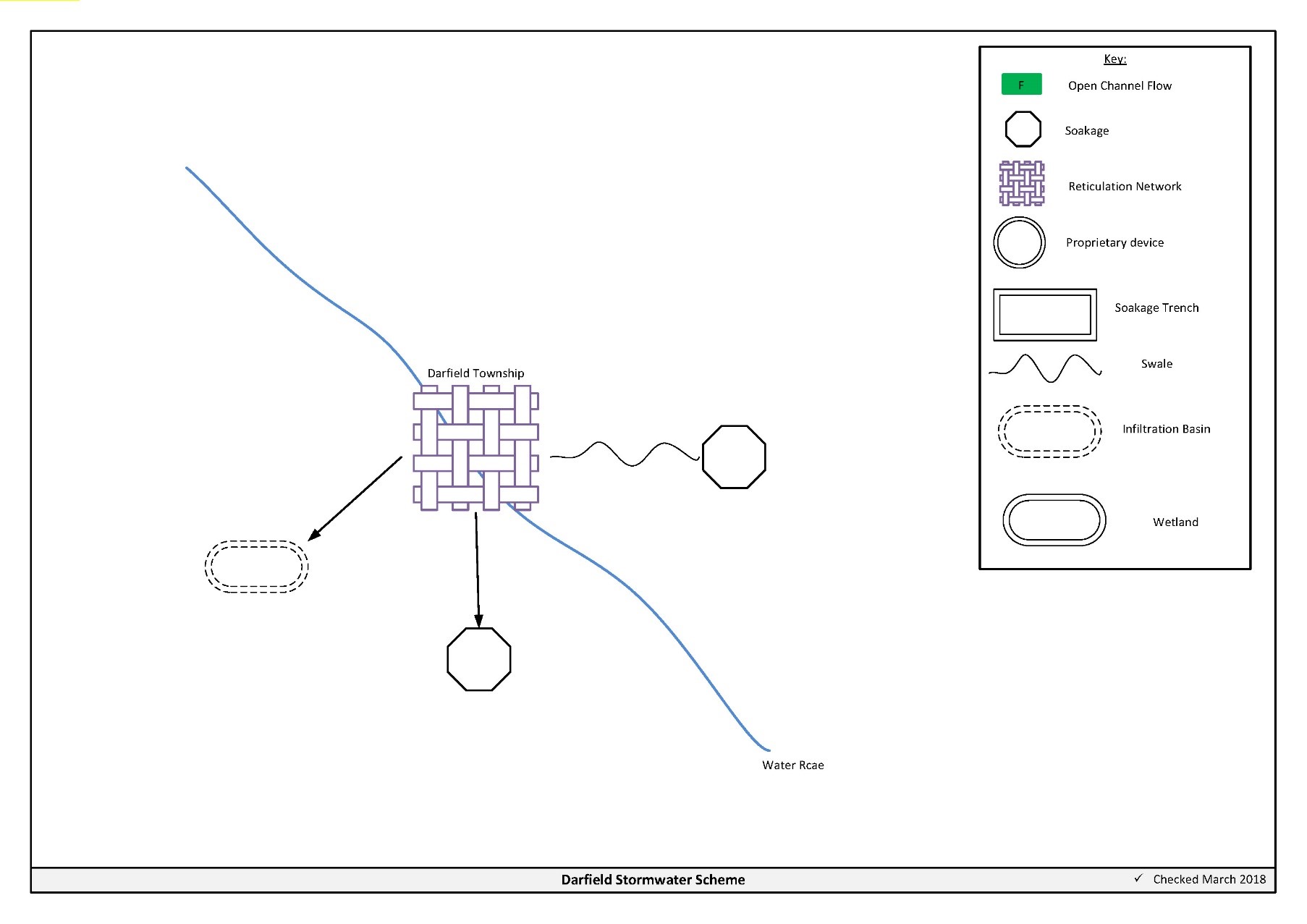
Figure 4‑2 Scheme Schematic
4.4 Resource Consents
The Darfield stormwater scheme has a number of resource consents. Table 4‑2 shows the stormwater discharge permitted by the resource consents for this scheme.
Table 4‑2 Resource Consents
CRC167465
Issued - Active | To discharge contaminants into and onto land | Darfield, Selwyn | 12/04/2014 | 12/04/2052 |
CRC102282
Issued - Active | To discharge stormwater to ground. | Mathias street, DARFIELD | N/A
| N/A
|
Stonewood Holdings installed the stormwater basin off Mathias Street (named Darfield 3) in 2009. The basin was non-complying and Council has not to date (2018) accepted transfer of the consent CRC090559. Options were provided to Stonewood Holdings in February 2013.
4.5 Integrated Stormwater Management Plan
Environment Canterbury's Land and Water Regional Plan became operative on the 13th December 2018. Under policy 4.16, any reticulated stormwater system for an urban area requires a stormwater management plan. Additionally, from 1 January 2025, operators of reticulated stormwater systems will become responsible for the quality and quantity of all stormwater discharged from the reticulated stormwater system. The Darfield stormwater management plan was updated in 2021 and has been submitted to ECan. The Darfield scheme operates under a global consent (CRC167465).
4.6 Scheme Assets
Council has a wide variety of stormwater assets within the district. A brief description of the assets within this scheme is provided below:
a. Open drains – are channels used to convey stormwater. They are cost effective means to convey large volumes of water.
b. Soakholes – Are used to dispose of stormwater to ground in areas where the ground water table is low and soil permeability is high.
A summary of material and diameter for channels and pipes, where known, is shown below in Figure 4‑3 and Figure 4‑4.
Figure 4‑3 Pipe Material - Darfield
Figure 4‑4 Pipe Diameter – Darfield
4.7 Operational Management
The stormwater network is operated and maintained under two maintenance contracts as follows:
- Contract 1241: Water Services Contract. Contract is with SICON who undertakes investigations, conditions inspections, proactive and reactive maintenance and minor asset renewals.
- Contract 1202: Parks and Reserves Contract. Contract is with SICON who undertakes the maintenance of land scape features related to water services e.g. mowing, gardens etc.
Water quality sampling is completed under an agreement with Food and Health Ltd as required.
4.8 Photos of Main Assets
The photos below provide a summary of the types of assets found within this stormwater management area.
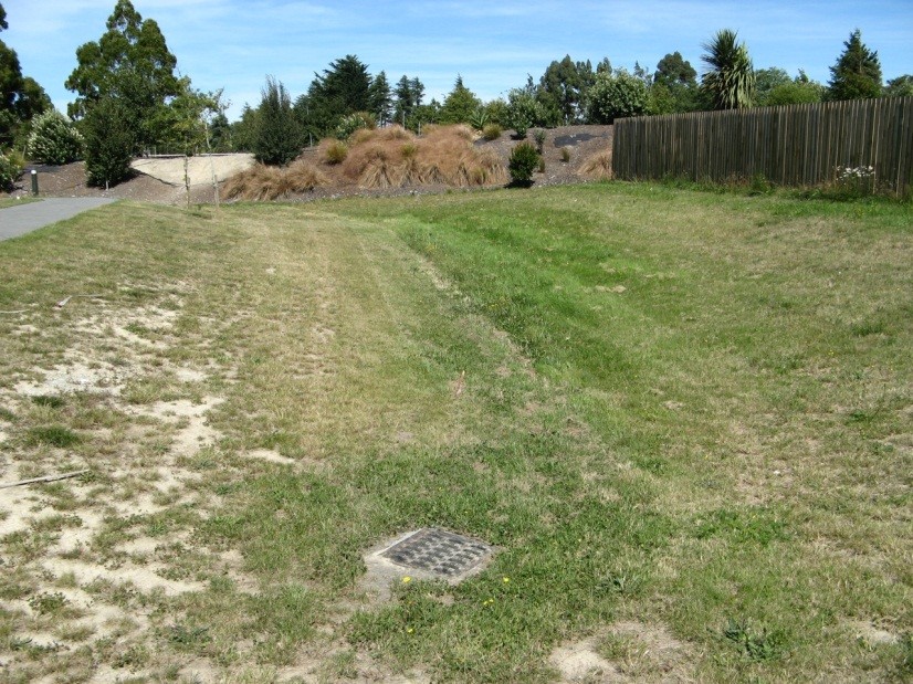
Photo 1: Typical grassed swale
4.9 Rapid Flood Modelling
The Council has undertaken 'Rapid Flood Hazard Assessment' modelling for its main townships. The modelling uses DHI MIKE 21 to simulate rainfall on grid with the outputs processed through ArcGIS producing maps illustrating a range of flood deeps during different rainfall intensities and durations.
The rapid flood assessment has been generated to provide a high level summary of potential flood and ponding areas across the district during extreme rainfall events. The results from this study are not to be used to set floor levels. The results have not been ground tested and therefore are indicative only.
For a 50 year event, Figure 4‑5 shows the predicted flooding for Darfield.
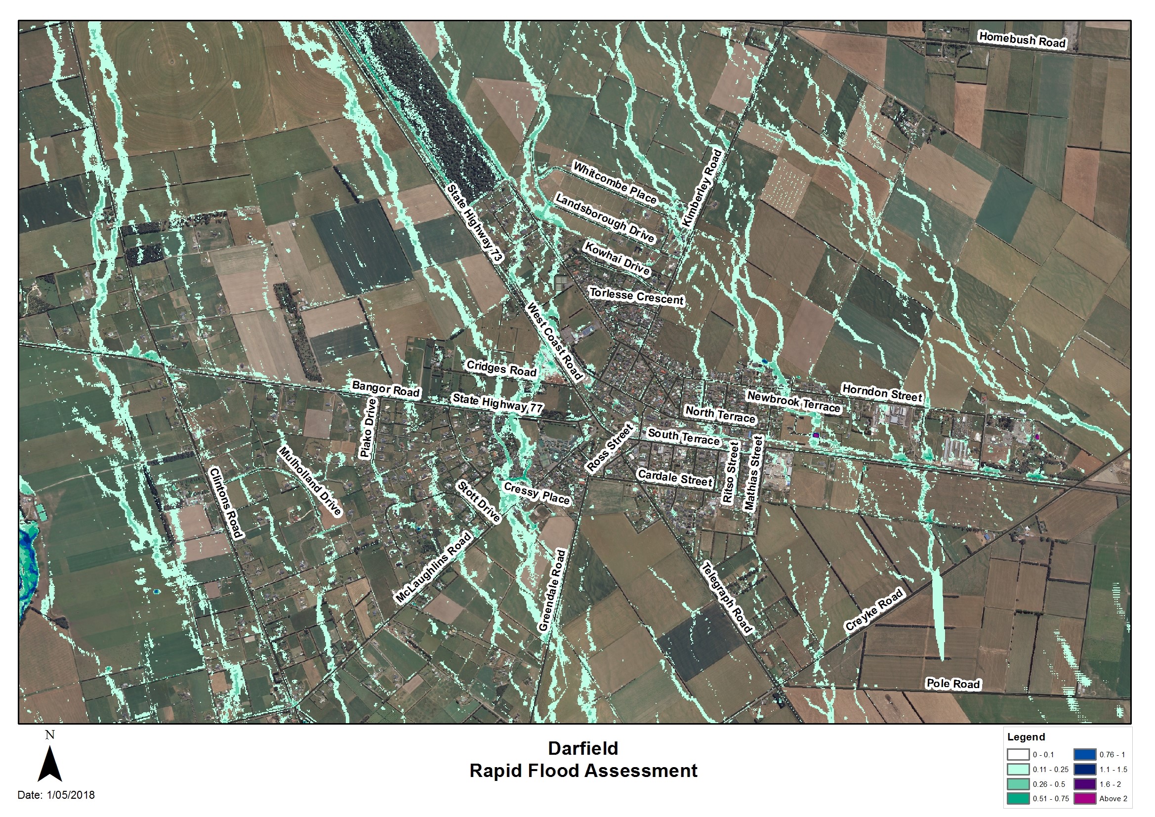
Figure 4‑5 Rapid Flood Modelling, Darfield
4.10 Risk Assessment
A risk assessment has been undertaken for the Darfield scheme. The key output from the risk assessment is the identification of any extreme and high risks which need to be mitigated. In order to mitigate these risks they have been included and budgeted for in the projects within this LTP. Table 4‑4 outlines the risks.
Table 4‑3 Risk Priority Rating
| > 50 | Extreme | Awareness of the event to be reported to Council. Urgent action to eliminate / mitigate / manage the risk. Document risk and action in the AMP. |
| 35-50 | Very High | Risk to be eliminated / mitigated / managed through normal business planning processes with responsibility assigned. |
| 14-35 | High | Manage risk using routine procedures. |
| 3.5-14 | Moderate | Monitor the risk. |
| < 3.5 | Low | Awareness of the event to be reported to Council. Immediate action required to eliminate / mitigate / manage the risk. Document risk and action in the AMP. |
Table 4‑4 Risks – Darfield
| Non-consented activities | Renewal of consents | 2014 | 27 | 27 | 6 |
The list of district wide risks can be found in 5Waters Activity Management Plan: Volume 1.
4.11 Asset Valuation Details
The total replacement value of assets within the Darfield Scheme is $610,296 as detailed in Table 4‑5 below.
Table 4‑5 Replacement Value, Darfield
Stormwater Reticulation
| Channel | $320,398
|
| Inlet-Outlet-Point | $1,296
|
| Management Device | $42,048
|
| Manhole | $52,035
|
| Pipe | $186,794
|
| Soakhole | $7,724
|
4.12 Renewals
The renewal profile has been taken from the 2019 5 Waters Valuation. A graph showing the renewals for this scheme are shown by Figure 4‑6 below. The majority of assets requiring renewal are culverts/pipes which occur in the period 2036-2041.
Figure 4‑6 Darfield Stormwater Renewal Profile
4.13 Critical Assets
The criticality model for Darfield has been updated for the 2021 AcMP. The methodology of the criticality model can be found in 5Waters Activity Management Plan: Volume 1 and it provides details of how the criticality has been calculated for the reticulation assets. Table 4‑6 and Figure 4‑7 below show the calculated criticality for all of the assets within this scheme that have a recorded known length.
Table 4‑6 Length of Assets per Criticality Level
5
| Low | 9,071
|
4
| Medium-Low | 222
|
3
| Medium | 4
|
2
| Medium-High | 0
|
1
| High | 0
|
4.14 Asset Condition
The asset condition model was run for Darfield in 2021. The methodology of the model can be found in 5Waters Activity Management Plan: Volume 1 and it provides details of how the model has been calculated for the reticulation assets (particularly pipes). Figure 4‑8 below shows the level of asset condition for all of the assets within this scheme that have a recorded known condition.
Table 4‑7 provides a description of the condition rating used within the condition model.
Table 4‑7 Asset Condition Grading
| 1.0 | Excellent |
| 2.0 | Good |
| 3.0 | Moderate |
| 4.0 | Poor |
| 5.0+ | Fail |
4.15 Funding Program
There are no projects specific to the Darfield scheme in the 10 year LTP budgets, however the scheme will benefit from a number of district-wide initiatives. Expenditure and renewals have been reported on a district-wide basis in Volume 1.
An explanation of the categories within the budgets are as follows below:
-
Expenditure consists of operation and maintenance costs;
-
Renewals are replacement of assets which are nearing or exceeded their useful life;
-
Projects are investigations, decisions and planning activities which exclude capital works; and
-
Capital projects are activities involving physical works.
The list of district wide projects can be found in 5Waters Activity Management Plan: Volume 1.
Discussion on Projects
Projects have been determined based on their:
- Relevance to the scheme
- Requirement to be completed under legislation
- Ability to bring the scheme up to or maintain the Level of Service required under council's Asset Management Policy.
Many projects are jointly funded by more than one scheme and activity. Each scheme pays a pro-rata share only, equivalent to the number of connections.
Discussion on Capital and Projects
Where relevant, Capital (Levels of Service) and Capital (Growth) projects have been included in the scheme financial details.
Levels of Service Projects and growth splits have been provided to ensure the costs of population driven works are clear.
<<
5-Waters-Volume-4-Stormwater