<<
5-Waters-Volume-4-Stormwater
1 Arthurs Pass Stormwater Scheme
1.1 Scheme Summary
Scheme Area
| 23.18ha |
| Scheme Coverage (as at 1 Jan 2021) | Rating numbers | 136
|
System components
| Piped (m) | 920
|
| Swales (m) | 42 |
| Drains (m) | 938
|
| Manholes/Inspection Chambers (No.) | 7 |
| Treatment | 2 (Humeceptor + Oil Interceptor) |
| Other | Infiltration trench |
Value ($)
| Replacement Cost | $332,902
|
| Depreciated Replacement Cost | $270,933
|
| Financial | Operator cost (scheduled and reactive maintenance) per connection
| $57.11/connection
|
Planning
| Stormwater Management Plan | Draft |
| No. SDC stormwater consents | 2 |
Demand
| Mean Annual Rainfall (mm) | 4330 |
| 10% AEP (10 year) 1hr rainfall depth (mm) | 37.4 |
| Sustainability | Sustainable drain management practices | Adopted and Encouraged |
1.2 Key Issues
The following key issues are associated with the Arthurs Pass Stormwater Scheme. A list of district wide issues are located in 5Waters Activity Management Plan: Volume 1.
Table 1‑1 Arthurs Pass Scheme Issues
| Area outside the Outdoor Centre floods from the surrounding hillsides during heavy rainfall. Includes septic tank flooding. | Monitor effectiveness of minor improvements made, determine responsibility. |
| Soakage trench by the Railway underpass has limited capacity and other floods during large rainfall events. | Options analysis undertaken by Opus consultants in 2013 and Community Committee opted to improve maintenance and undertake no capital works. |
| Costs of undertaking maintenance works in the township are high including proprietary device cleaning due to travel distances. | Continue to work alongside roading contractor and the Community to achieve best value for money maintenance. |
1.3 Overview & History
The Arthurs Pass stormwater system services the car and bus parking and public toilet facility at Arthurs Pass. These facilities sit outside the NZTA system. Stormwater from the "bus and car parking area" is directed via kerb and channel to a rock-lined swale, and then piped to a proprietary device before discharging to a gravel soakage trench. Stormwater from the "DoC carpark" is directed via kerb and channel to a petrol and oil interceptor and then discharges via open drain to the same soakage trench.
Arthurs Pass has a high annual rainfall of 4330mm, which is the highest in the district.
The community committee raised concerns about the flooding of the underpass when the soakage trench capacity was exceeded (Refer to Photo 3 in Section 1.8). An investigation of options to improve drainage of the soakage trench was undertaken by Opus Consultants in 2013. The community committee opted to remain with the status quo with additional maintenance.
Flooding is known to occur outside the outdoor centre from the drain on private property behind the store, minor improvements to the culvert was made in 2013 by the roading team and will be monitored.
Due to the isolated nature of the community in Arthurs Pass, a high level of communication with the community committee is required to help identify issues and opportunities for improvement.
There are a number of stormwater issues in Arthurs Pass on private property which are outside Council control.
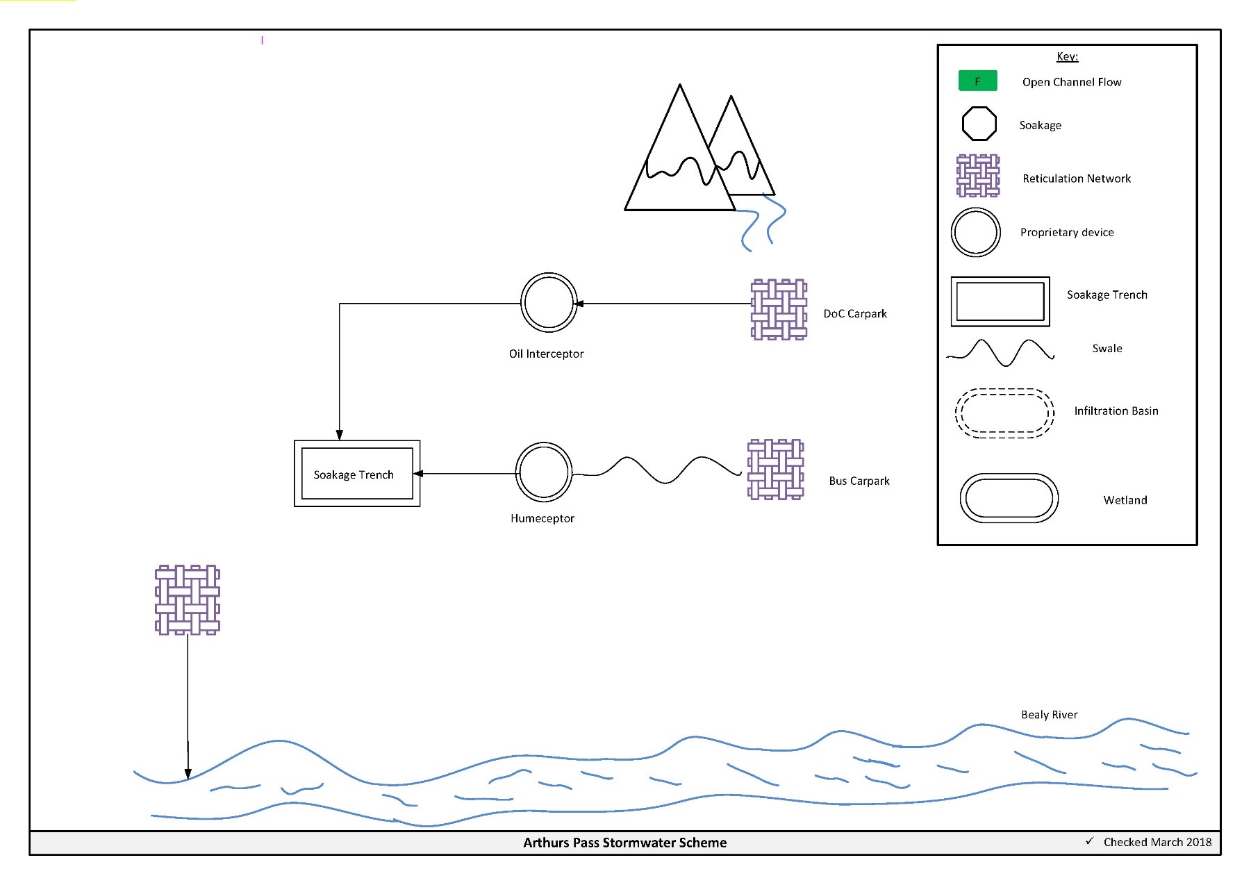
Figure 1‑2 Scheme Schematic
1.4 Resource Consents
The Arthurs Pass stormwater scheme has a number of resource consents. Table 1‑2 shows the stormwater discharge permitted by the resource consents for this scheme.
Table 1‑2 Resource Consents
CRC080003
| To discharge stormwater to land from roofing and hardstand | State Highway 73, ARTHURS PASS | 30/10/2007 | 25/10/2042 |
CRC084392
| To discharge hardstand stormwater to ground.
| Cloudesley Road, BEALEY SPUR
| N/A
| N/A
|
CRC186179
| To discharge stormwater to land and to surface water from the existing stormwater network of Arthur's Pass
| Arthur's Pass
| Application on hold
| -
|
Consent CRC084392 is located outside the stormwater management area but is included for completeness.
1.5 Integrated Stormwater Management Plan
Environment Canterbury's Land and Water Regional Plan became operative on the 13th December 2018. Under policy 4.16, any reticulated stormwater system for an urban area requires a stormwater management plan. Additionally, from 1 January 2025, operators of reticulated stormwater systems will become responsible for the quality and quantity of all stormwater discharged from the reticulated stormwater system. The Arthurs Pass stormwater management plan has been lodged as part of the application for consent CRC186179.
1.6 Scheme Assets
Council has a wide variety of stormwater assets within the district. A brief description of the assets within this scheme is provided below:
a. Reticulated network – Includes pipes, manholes, sumps. The primary purpose of the reticulated network is to collect and convey stormwater. Historically these systems were designed for the 2 year storm event. Today's engineering standards require the piped network to be designed for a 10 year event with overland flow provision for up to the 50 year event.
b. Oil Interceptor – Is a proprietary device which uses baffles to trap and contain hydrocarbons (oils and fuels).
c. Humeceptor - Is a hydrodynamic separator which helps to reduce mass sediment load from the discharge, some removal of hydrocarbons is also achieved.
d. Swale (Rock lined) – Is a longitudinal open channel which is lined with rocks. The swale both conveys and treats stormwater.
e. Soakage trench – Carries out the same function as soakholes but is orientated in a horizontal direction rather than vertically. They are particularly useful in areas with reduced infiltration rates or higher ground water tables.
A summary of material and diameter for channels and pipes, where known, is shown below in Figure 1‑3 and Figure 1‑4.
Figure 1‑3 Pipe Material – Arthurs Pass
Figure 1‑4 Pipe Diameter – Arthurs Pass
1.7 Operational Management
The stormwater network is operated and maintained under two maintenance contracts as follows:
- Contract 1241: Water Services Contract. Contract is with SICON who undertakes investigations, conditions inspections, proactive and reactive maintenance and minor asset renewals.
- Contract 1202: Parks and Reserves Contract. Contract is with SICON who undertakes the maintenance of land scape features related to water services e.g. mowing, gardens etc.
Water quality sampling is completed under an agreement with Food and Health Ltd as required.
1.8 Photos of Main Assets
The photos below provide a summary of the types of assets found within this stormwater management area.
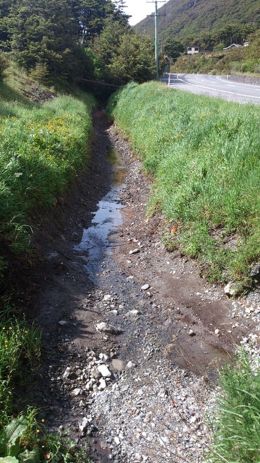
Photo 1: Soakage Trench
|
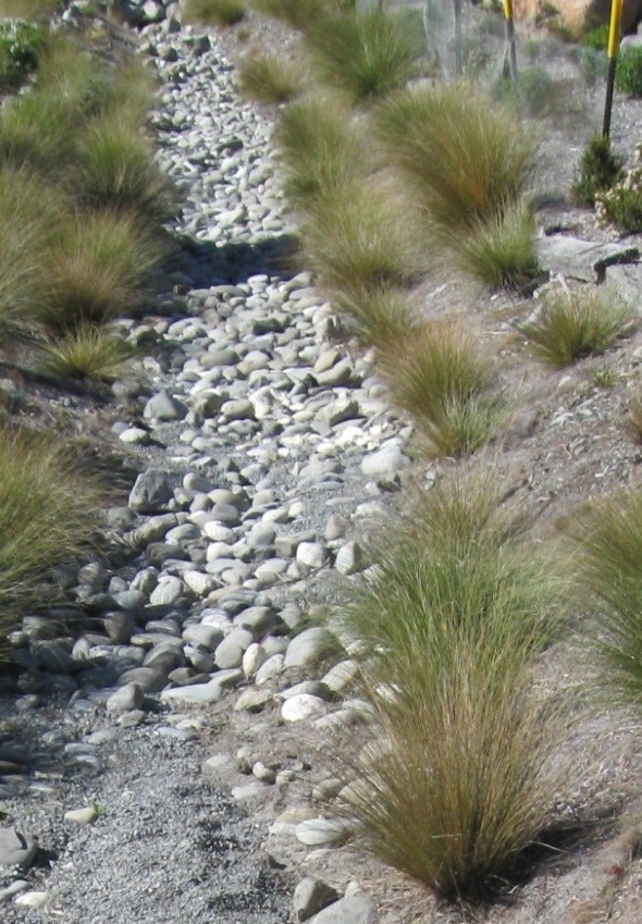
Photo 2: Rock lined swale
|
The soakage trench in Photo 1 requires an annual clean of accumulated sediment.
1.9 Rapid Flood Modelling
The Council has undertaken 'Rapid Flood Hazard Assessment' modelling for its main townships. The modelling uses DHI MIKE 21 to simulate rainfall on grid with the outputs processed through ArcGIS producing maps illustrating a range of flood deeps during different rainfall intensities and durations.
The rapid flood assessment has been generated to provide a high level summary of potential flood and ponding areas across the district during extreme rainfall events. The results from this study are not to be used to set floor levels. The results have not been ground tested and therefore are indicative only.
For a 50 year event, no flooding is expected in Arthurs Pass.
1.10 Risk Assessment
A risk assessment has been undertaken for the Arthurs Pass scheme. The key output from the risk assessment is the identification of any extreme and high risks which need to be mitigated. In order to mitigate these risks they have been included and budgeted for in the projects within this LTP. Table 1‑3 details the risk priority matrix and Table 1‑4 outlines the risks for this scheme.
Table 1‑3 Risk Priority Rating
| > 50 | Extreme | Awareness of the event to be reported to Council. Urgent action to eliminate / mitigate / manage the risk. Document risk and action in the AMP. |
| 35-50 | Very High | Risk to be eliminated / mitigated / managed through normal business planning processes with responsibility assigned. |
| 14-35 | High | Manage risk using routine procedures. |
| 3.5-14 | Moderate | Monitor the risk. |
| < 3.5 | Low | Awareness of the event to be reported to Council. Immediate action required to eliminate / mitigate / manage the risk. Document risk and action in the AMP. |
Table 1‑4 Risks – Arthurs Pass
| Non-consented activities | Renewal of consents | 2014 | 27 | 27 | 6 |
| Network maintenance | review public / private drains | 2017 | | 12 | 2 |
| Scheme capacity | infiltration basin overflow design + consent | 2017 | | 27 | 12 |
| Scheme capacity | infiltration basin overflow construction | 2017 | | 27 | 12 |
The list of district wide risks can be found in 5Waters Activity Management Plan: Volume 1.
1.11 Asset Valuation Details
The total replacement value of assets within the Arthurs Pass Scheme is $332,902 as detailed in Table 1‑5 below.
Table 1‑5 Replacement Value, Arthurs Pass
Stormwater Reticulation
| Channel | $59,488
|
| Inlet-Outlet-Point | $17,280
|
| Lateral | $23,181
|
| Management Device | $37,648
|
| Manhole | $48,801
|
| Pipe | $146,503
|
1.12 Renewals
The renewal profile has been taken from the 2019 5 Waters Valuation. A graph showing the renewals for this scheme are shown by Figure 1‑5 below. The majority of assets requiring renewal are culverts/pipes which occur in the year 2040/41.
Figure 1‑5 Arthurs Pass Stormwater Renewal Profile
1.13 Critical Assets
The criticality model for Arthurs Pass has been updated for the 2021 AcMP. The methodology of the criticality model can be found in 5Waters Activity Management Plan: Volume 1 and it provides details of how the criticality has been calculated for the reticulation assets. Table 1‑6 and Figure 1‑6 below show the calculated criticality for all of the assets within this scheme that have a recorded known length.
Table 1‑6 Length of Assets per Criticality Level
5
| Low | 711
|
4
| Medium-Low | 216
|
3
| Medium | 148
|
2
| Medium-High | 0 |
1
| High | 52
|
1.14 Asset Condition
The asset condition model was run for Arthurs Pass in 2021. The methodology of the model can be found in 5Waters Activity Management Plan: Volume 1 and it provides details of how the model has been calculated for the reticulation assets (particularly pipes). Figure 1‑7 below shows the level of asset condition for all of the assets within this scheme that have a recorded known condition.
Table 1‑7 provides a description of the condition rating used within the condition model.
Table 1‑7 Asset Condition Grading
| 1.0 | Excellent |
| 2.0 | Good |
| 3.0 | Moderate |
| 4.0 | Poor |
| 5.0+ | Fail |
1.15 Funding Program
The 10 year budgets for Arthurs Pass are shown by Table 1‑10. Budgets are split into expenditure, renewals, projects and capital projects. Expenditure and renewals have been reported on a district-wide basis in Volume 1.
All figures are ($) not adjusted for CPI “inflation". They are calculated on historical data, and population growth where relevant.
Table 1‑8 Arthurs Pass Budget Summary
| 2021/2022 | -
| $30,000
|
2022/2023
| -
| $480,000
|
| 2023/2024 | -
| $20,000
|
| 2024/2025 | -
| -
|
| 2025/2026 | -
| -
|
| 2026/2027 | -
| $150,000
|
| 2027/2028 | -
| - |
2028/2029
| -
| -
|
2029/2030
| -
| -
|
2031/2032
| -
| -
|
| Total | -
| $680,000
|
An explanation of the categories within the budgets are as follows below:
-
Expenditure consists of operation and maintenance costs;
-
Renewals are replacement of assets which are nearing or exceeded their useful life;
-
Projects are investigations, decisions and planning activities which exclude capital works; and
-
Capital projects are activities involving physical works.
Table 1‑9 Key Projects
Capital Projects
| -
| Underpass flooding; connect soakage basin to Bealey River via a high-level overflow
| $30,000
| $480,000
| -
| -
| TBC
|
Capital Projects
| -
| Punchbowl Creek piping; identify options for alternative flow paths from highway to Bealey River via Punchbowl Road
| -
| -
| $20,000
| $150,000
| 100% LoS
|
* Where LoS refers to Level of Service and G refers to Growth
The list of district wide projects can be found in 5Waters Activity Management Plan: Volume 1.
Discussion on Projects
Projects have been determined based on their:
- Relevance to the scheme
- Requirement to be completed under legislation
- Ability to bring the scheme up to or maintain the Level of Service required under council's Asset Management Policy.
Many projects are jointly funded by more than one scheme and activity. Each scheme pays a pro-rata share only, equivalent to the number of connections.
Discussion on Capital and Projects
Where relevant, Capital (Levels of Service) and Capital (Growth) projects have been included in the scheme financial details.
Levels of Service Projects and growth splits have been provided to ensure the costs of population driven works are clear.
<<
5-Waters-Volume-4-Stormwater